 with our Megalithic Portal iPhone app")


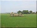
<< Our Photo Pages >> The Knock (Leylodge) - Standing Stone (Menhir) in Scotland in Aberdeenshire
Submitted by golux on Monday, 13 June 2011 Page Views: 6970
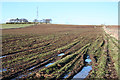
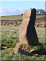
Neolithic and Bronze AgeSite Name: The Knock (Leylodge) Alternative Name: South LeylodgeCountry: Scotland County: Aberdeenshire Type: Standing Stone (Menhir)
Nearest Town: Kintore Nearest Village: Leylodge
Map Ref: NJ7611813345
Latitude: 57.210243N Longitude: 2.396994W
Condition:
| 5 | Perfect |
| 4 | Almost Perfect |
| 3 | Reasonable but with some damage |
| 2 | Ruined but still recognisable as an ancient site |
| 1 | Pretty much destroyed, possibly visible as crop marks |
| 0 | No data. |
| -1 | Completely destroyed |
| 5 | Superb |
| 4 | Good |
| 3 | Ordinary |
| 2 | Not Good |
| 1 | Awful |
| 0 | No data. |
| 5 | Can be driven to, probably with disabled access |
| 4 | Short walk on a footpath |
| 3 | Requiring a bit more of a walk |
| 2 | A long walk |
| 1 | In the middle of nowhere, a nightmare to find |
| 0 | No data. |
| 5 | co-ordinates taken by GPS or official recorded co-ordinates |
| 4 | co-ordinates scaled from a detailed map |
| 3 | co-ordinates scaled from a bad map |
| 2 | co-ordinates of the nearest village |
| 1 | co-ordinates of the nearest town |
| 0 | no data |
Internal Links:
External Links:
 (PID:77816)")
RCAHMS (Site no. 18708) do not explain why they think it has fallen: the pyramid shape would make it very hard to topple and if stood on end it would not be much taller.
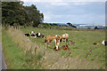
(Beware faux stones - the neighbouring fields feature three prominently placed stone pillars which are shown on the OS map as Standing Stones but are now classified as cattle rubbing stones.)
You may be viewing yesterday's version of this page. To see the most up to date information please register for a free account.
 (PID:77815)")
Do not use the above information on other web sites or publications without permission of the contributor.
Nearby Images from Geograph Britain and Ireland:
©2016(licence)
©2009(licence)
©2007(licence)
©2016(licence)
©2006(licence)
The above images may not be of the site on this page, they are loaded from Geograph.
Please Submit an Image of this site or go out and take one for us!
Click here to see more info for this site
Nearby sites
Key: Red: member's photo, Blue: 3rd party photo, Yellow: other image, Green: no photo - please go there and take one, Grey: site destroyed
Download sites to:
KML (Google Earth)
GPX (GPS waypoints)
CSV (Garmin/Navman)
CSV (Excel)
To unlock full downloads you need to sign up as a Contributory Member. Otherwise downloads are limited to 50 sites.
Turn off the page maps and other distractions
Nearby sites listing. In the following links * = Image available
567m E 98° South Ley Lodge* Stone Circle (NJ76681326)
2.3km SSE 163° Breemie Stones* Modern Stone Circle etc (NJ768111)
3.2km SE 139° South Fornet* Stone Circle (NJ782109)
3.5km NNE 18° Ratch-hill Ancient Village or Settlement (NJ772167)
3.8km ENE 62° Midmill Chambered Cairn (NJ795151)
3.9km ENE 58° Tuack* Stone Circle (NJ795154)
4.0km SSW 199° Nether Corskie Pictish Symbol Stone Class I Pictish Symbol Stone (NJ74830960)
4.0km SSW 199° Nether Corskie Stone Circle* Stone Circle (NJ74820959)
4.0km W 261° John Bell's Stone* Standing Stone (Menhir) (NJ72111271)
4.0km NE 45° Kintore 4 Class I Pictish Symbol Stone (NJ790162)
4.0km WNW 293° Lang Stane o' Craigearn* Standing Stone (Menhir) (NJ72381493)
4.3km ENE 73° Ferneybrae* Standing Stone (Menhir) (NJ80211459)
4.3km NE 47° Kintore 1* Class I Pictish Symbol Stone (NJ79301628)
4.4km W 259° Castle Fraser Row* Stone Row / Alignment (NJ71741252)
4.7km W 260° Castle Fraser circle* Stone Circle (NJ71501253)
4.9km NNE 29° Cairnhall Stone Circle (NJ78501759)
5.0km W 271° Woodend of Cluny* Standing Stone (Menhir) (NJ7105613433)
5.1km NNE 26° Fullerton* Stone Circle (NJ7839517969)
5.3km SE 129° Drum Stone* Natural Stone / Erratic / Other Natural Feature (NJ802100)
5.4km SE 134° Drumstone Ring Ditch Ancient Village or Settlement (NJ800096)
5.4km E 94° Newton of Lewesk* Class I Pictish Symbol Stone (NJ815129)
5.5km SSW 204° Wester Echt* Stone Circle (NJ73840836)
5.6km E 84° Cairntradlin* Standing Stone (Menhir) (NJ81681385)
5.6km WNW 294° Nether Coullie* Stone Circle (NJ70981565)
5.7km N 7° Bruce's Camp* Hillfort (NJ76851900)
View more nearby sites and additional images


 We would like to know more about this location. Please feel free to add a brief description and any relevant information in your own language.
 Wir möchten mehr über diese Stätte erfahren. Bitte zögern Sie nicht, eine kurze Beschreibung und relevante Informationen in Deutsch hinzuzufügen.
 Nous aimerions en savoir encore un peu sur les lieux. S'il vous plaît n'hesitez pas à ajouter une courte description et tous les renseignements pertinents dans votre propre langue.
 Quisieramos informarnos un poco más de las lugares. No dude en añadir una breve descripción y otros datos relevantes en su propio idioma.