


<< Our Photo Pages >> Brown Hills Beck East - Round Barrow(s) in England in Lancashire
Submitted by LivingRocks on Tuesday, 07 June 2005 Page Views: 6023
Neolithic and Bronze AgeSite Name: Brown Hills Beck EastCountry: England County: Lancashire Type: Round Barrow(s)
Nearest Town: Settle Nearest Village: Rathmell
Map Ref: SD75656025
Latitude: 54.037649N Longitude: 2.373291W
Condition:
| 5 | Perfect |
| 4 | Almost Perfect |
| 3 | Reasonable but with some damage |
| 2 | Ruined but still recognisable as an ancient site |
| 1 | Pretty much destroyed, possibly visible as crop marks |
| 0 | No data. |
| -1 | Completely destroyed |
| 5 | Superb |
| 4 | Good |
| 3 | Ordinary |
| 2 | Not Good |
| 1 | Awful |
| 0 | No data. |
| 5 | Can be driven to, probably with disabled access |
| 4 | Short walk on a footpath |
| 3 | Requiring a bit more of a walk |
| 2 | A long walk |
| 1 | In the middle of nowhere, a nightmare to find |
| 0 | No data. |
| 5 | co-ordinates taken by GPS or official recorded co-ordinates |
| 4 | co-ordinates scaled from a detailed map |
| 3 | co-ordinates scaled from a bad map |
| 2 | co-ordinates of the nearest village |
| 1 | co-ordinates of the nearest town |
| 0 | no data |
Internal Links:
External Links:
I have visited· I would like to visit
SolarMegalith would like to visit
watersnake visited on 5th Sep 2015 - their rating: Cond: 5 Access: 2 Brown Hills Barrows.
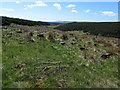
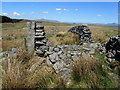
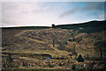
Sited on the northern edge of Gisburn Forest , alongside Brown Hills Beck .
The walk from Rathmell requires endurance and waterproof footwear .
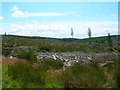
The site of these two barrows is almost totally surrounded by hills and forest plantation .
The largest structure is impressive in size and shape, and is home to a variety of native flowering plants ; the smaller being partially inaccessible and less central to the site .
")
Up to 10m high with maximum dimensions of 40m by 30m, the long axis is aligned along the valley.
You may be viewing yesterday's version of this page. To see the most up to date information please register for a free account.
")
Do not use the above information on other web sites or publications without permission of the contributor.
Nearby Images from Geograph Britain and Ireland:
©2013(licence)

©2025(licence)
©2013(licence)
©2009(licence)
©2010(licence)
The above images may not be of the site on this page, they are loaded from Geograph.
Please Submit an Image of this site or go out and take one for us!
Click here to see more info for this site
Nearby sites
Key: Red: member's photo, Blue: 3rd party photo, Yellow: other image, Green: no photo - please go there and take one, Grey: site destroyed
Download sites to:
KML (Google Earth)
GPX (GPS waypoints)
CSV (Garmin/Navman)
CSV (Excel)
To unlock full downloads you need to sign up as a Contributory Member. Otherwise downloads are limited to 50 sites.
Turn off the page maps and other distractions
Nearby sites listing. In the following links * = Image available
108m NNW 338° Brown Hills Beck* Round Barrow(s) (SD75616035)
6.5km E 79° Cleatop Park* Stone Circle (SD82056145)
6.7km ENE 57° Bank Well* Holy Well or Sacred Spring (SD813639)
7.0km NE 42° The Ebbing and Flowing Well* Holy Well or Sacred Spring (SD80396538)
7.4km W 275° Cross of Greet* Carving (SD6823560888)
7.5km NNE 23° Feizor (Lawkland) Standing Stone (Menhir) (SD78586718)
7.8km NE 40° Apronful of Stones (Giggleswick) Cairn (SD8065266193)
7.9km NE 38° Sheep Scar Circle (Giggleswick) Ring Cairn (SD8051366473)
8.0km NE 39° Sheep Scar Cairn (Giggleswick) Cairn (SD8067866436)
8.1km NE 37° Feizor Thwaite Propped Stone* Rock Outcrop (SD8057466703)
8.3km NNE 29° Feizor Thwaite (Lawkland)* Ring Cairn (SD79796747)
8.4km NNE 31° Feizor Celtic Wall* Misc. Earthwork (SD8008067386)
9.3km ENE 61° Attermire Scar (Settle)* Rock Art (SD83836464)
9.3km SSW 209° Slaidburn Angel Stone* Sculptured Stone (SD7103552188)
9.3km SSW 209° Balaam's Grove burial mound Round Barrow(s) (SD7112652069)
9.4km ENE 59° Victoria Cave* Cave or Rock Shelter (SD838650)
9.4km ENE 59° Albert Cave Cave or Rock Shelter (SD83796508)
9.6km NE 51° Samson's Toe (Langcliffe) Natural Stone / Erratic / Other Natural Feature (SD8317666229)
9.8km N 5° Norber Erratics Natural Stone / Erratic / Other Natural Feature (SD76597003)
10.6km NW 305° The Great Stone Of Fourstones* Natural Stone / Erratic / Other Natural Feature (SD6697266292)
10.6km SSW 200° Skelshaw Ring (Easington) Ancient Village or Settlement (SD71915036)
10.6km WNW 299° Ringstones (Lowgill) Stone Circle (SD664655)
10.8km N 358° Ingleborough Cave* Natural Stone / Erratic / Other Natural Feature (SD7542071093)
11.2km ENE 74° Rye Loaf Hill (Settle) Cairn (SD8641963309)
11.3km SSE 165° St Peter and St Paul's Church, Bolton-by-Bowland* Sculptured Stone (SD786493)
View more nearby sites and additional images


 We would like to know more about this location. Please feel free to add a brief description and any relevant information in your own language.
 Wir möchten mehr über diese Stätte erfahren. Bitte zögern Sie nicht, eine kurze Beschreibung und relevante Informationen in Deutsch hinzuzufügen.
 Nous aimerions en savoir encore un peu sur les lieux. S'il vous plaît n'hesitez pas à ajouter une courte description et tous les renseignements pertinents dans votre propre langue.
 Quisieramos informarnos un poco más de las lugares. No dude en añadir una breve descripción y otros datos relevantes en su propio idioma.