

<< Our Photo Pages >> Trestle Cairn - Stone Circle in Scotland in Scottish Borders
Submitted by Andy B on Thursday, 27 February 2003 Page Views: 7002
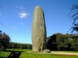
Neolithic and Bronze AgeSite Name: Trestle Cairn Alternative Name: Dere Street II, Plea Shank CairnCountry: Scotland County: Scottish Borders Type: Stone Circle
Nearest Town: Hownam Nearest Village: Dere Street
Map Ref: NT75181612 Landranger Map Number: 80
Latitude: 55.438327N Longitude: 2.393834W
Condition:
| 5 | Perfect |
| 4 | Almost Perfect |
| 3 | Reasonable but with some damage |
| 2 | Ruined but still recognisable as an ancient site |
| 1 | Pretty much destroyed, possibly visible as crop marks |
| 0 | No data. |
| -1 | Completely destroyed |
| 5 | Superb |
| 4 | Good |
| 3 | Ordinary |
| 2 | Not Good |
| 1 | Awful |
| 0 | No data. |
| 5 | Can be driven to, probably with disabled access |
| 4 | Short walk on a footpath |
| 3 | Requiring a bit more of a walk |
| 2 | A long walk |
| 1 | In the middle of nowhere, a nightmare to find |
| 0 | No data. |
| 5 | co-ordinates taken by GPS or official recorded co-ordinates |
| 4 | co-ordinates scaled from a detailed map |
| 3 | co-ordinates scaled from a bad map |
| 2 | co-ordinates of the nearest village |
| 1 | co-ordinates of the nearest town |
| 0 | no data |
Internal Links:
External Links:
I have visited· I would like to visit
bishop_pam visited on 24th Aug 2017 - their rating: Cond: 3 Amb: 3 Access: 2
Anne T visited on 23rd Apr 2015 - their rating: Cond: 3 Amb: 4 Access: 3 Trestle Cairn, off Dere Street, Scottish Borders: Continuing north up Dere Street from the Black Knowe standing stone, the stone wall is continuous uphill. To get back to Black Knowe Cairn we either had to carry on to Trestle Cairn then double back to Black Knowe Cairn or walk back down the hill to a gate lower down the field at the lower field boundary and walk back uphill to Black Knowe Cairn. We chose the former.
Continuing uphill, there is a gate in the next field boundary. At the time of our visit there was stock in the field and an electric fence which we had to duck under. A few yards to the left hand side there was a gate into the field immediately below Trestle Cairn. 50 yards along the stone wall to the left there was a gate into the Trestle Cairn field giving easy access to the cairn.
The Canmore/RCAHMS records for this site (Canmore ID 57949 Site Number NT71NE 34) record in 1947 that this is a ‘Druidical Circle .... consists of 17 stones distributed within the circumference of a demolished cairn which originally measured 55’ in diameter’. There were clearly 2 ovals/circles of irregularly placed stones with banks and ditches around them. My impression was that this was a cairn, with some similarities to the Loupin’ Stanes which we’d seen near Eskdalemuir a few weeks before. The views to the west and south were stunning at this time of early evening, with the distant hills bleeding into the grey of the dusk.
From here we could see the Five Stones Stone Circles down in the valley to the right of Dere Street, which we’d hoped to make it to that day. The walking had been slower than we anticipated so we stayed to photograph and appreciate the location of this cairn and made our way downhill to Black Knowe Cairn. There is so much to see in this area that we’re going to make another trip, with the Five Stones Stone Circles top of the list.
Note for future visitors: returning to the gate in the field within Plea Shank, don’t go back to the gate onto Dere Street. Continuing down the field you will come to some smoothly mown pathways within the heavily tussocked grass. These lead back to Trestle Cairn and is easier walking than in the long grass.
h_fenton Andy B have visited here
Average ratings for this site from all visit loggers: Condition: 3 Ambience: 3.5 Access: 2.5
")
Information about this impressive cairn can be found in Canmore ID 57949, which also refers to this as a Druidical Circle.
Canmore tells us that in 1947, it was recorded that: "Trestle Cairn stands on a ridge. Its remains consist of 17 stones distributed within the circumference of a demolished cairn which originally measured 55' in diameter. Only the two westernmost stones ... are now earthfast, both standing 2'5" in height and both at a distance of 8' within the margin of the cairn, which is marked here for a length of 20' by an arc of undisturbed material which still attains a height of 1'. Apart from this fragment, everything has been disturbed, and the remaining part of the cairn rises to a maximum height of 2'6" above ground level. The other 15 stones have been moved and in many cases broken, so that any arrangement in which they now lie is fortuitous."
In 1995, an update reported the cairn: "stands on top of an unnamed hill some 200m E of Plea Shank. It measures c.15m in diameter and stands some 0.7m high, with several boulders set on edge within the circumference along the S side of the demolished cairn. The cairn has an uneven surface and is badly disturbed."
You may be viewing yesterday's version of this page. To see the most up to date information please register for a free account.
")
")
")
")
")
")
")
")
")
")
")
Do not use the above information on other web sites or publications without permission of the contributor.
Click here to see more info for this site
Nearby sites
Key: Red: member's photo, Blue: 3rd party photo, Yellow: other image, Green: no photo - please go there and take one, Grey: site destroyed
Download sites to:
KML (Google Earth)
GPX (GPS waypoints)
CSV (Garmin/Navman)
CSV (Excel)
To unlock full downloads you need to sign up as a Contributory Member. Otherwise downloads are limited to 50 sites.
Turn off the page maps and other distractions
Nearby sites listing. In the following links * = Image available
216m SW 236° Five Stanes B Stone Circle (NT7516)
582m S 185° Black Knowe (Borders)* Standing Stone (Menhir) (NT75131554)
611m S 191° Dere Street Cairn* Round Cairn (NT75061552)
623m E 97° Dere Street stone* Standing Stone (Menhir) (NT75801604)
744m N 6° Five Stanes A* Stone Circle (NT75261686)
1.4km SSW 199° Falla Knowe Cairn* Cairn (NT74711475)
1.6km ENE 71° Chatto Craig* Hillfort (NT76701662)
2.7km ENE 75° Dodlaw Burn* Standing Stone (Menhir) (NT77791681)
2.8km E 81° Dodlaw Cairn Round Cairn (NT77991655)
2.9km ENE 71° Little Heuch Law Cairn* Cairn (NT77921705)
3.1km SW 221° Dark Wood* Cairn (NT73111377)
3.9km SSE 156° Woden Law* Hillfort (NT76771254)
4.3km NE 50° Horseshoe Wood Settlement* Ancient Village or Settlement (NT78511891)
4.5km SE 134° Standard Knowe Cairn (NT78411300)
4.5km NE 52° Horseshoe Wood (Hownam)* Standing Stone (Menhir) (NT78741890)
5.0km NE 51° The Shearers* Stone Row / Alignment (NT79101925)
5.0km NE 49° Hownam Rings Hill Fort* Hillfort (NT79041939)
5.1km SSE 161° Hindhope Hill Hillfort* Hillfort (NT76811127)
5.2km SSE 158° Hindhope Hill Cairn* Cairn (NT7710811310)
5.7km SW 214° Moor Head (Brundean Laws)* Standing Stones (NT7193111439)
6.1km S 175° Upper Hindhope* Standing Stones (NT75641008)
7.4km NE 37° Hownam Law Hillfort* Hillfort (NT7964022000)
8.1km WSW 243° Edgerston Hillfort (NT67981245)
8.2km ENE 68° Calroust Hillfort* Hillfort (NT828192)
8.3km SW 223° Knock Hill Cairn Cairn (NT69451016)
View more nearby sites and additional images


 We would like to know more about this location. Please feel free to add a brief description and any relevant information in your own language.
 Wir möchten mehr über diese Stätte erfahren. Bitte zögern Sie nicht, eine kurze Beschreibung und relevante Informationen in Deutsch hinzuzufügen.
 Nous aimerions en savoir encore un peu sur les lieux. S'il vous plaît n'hesitez pas à ajouter une courte description et tous les renseignements pertinents dans votre propre langue.
 Quisieramos informarnos un poco más de las lugares. No dude en añadir una breve descripción y otros datos relevantes en su propio idioma.