

<< Our Photo Pages >> Cow Stone (Scottish Borders) - Standing Stone (Menhir) in Scotland in Scottish Borders
Submitted by cosmic on Tuesday, 31 August 2004 Page Views: 11386
Neolithic and Bronze AgeSite Name: Cow Stone (Scottish Borders) Alternative Name: Brotherstone HillCountry: Scotland
NOTE: This site is 1.3 km away from the location you searched for.
County: Scottish Borders Type: Standing Stone (Menhir)
Nearest Town: St. Boswells Nearest Village: Brotherstone
Map Ref: NT62163620 Landranger Map Number: 74
Latitude: 55.617908N Longitude: 2.602356W
Condition:
| 5 | Perfect |
| 4 | Almost Perfect |
| 3 | Reasonable but with some damage |
| 2 | Ruined but still recognisable as an ancient site |
| 1 | Pretty much destroyed, possibly visible as crop marks |
| 0 | No data. |
| -1 | Completely destroyed |
| 5 | Superb |
| 4 | Good |
| 3 | Ordinary |
| 2 | Not Good |
| 1 | Awful |
| 0 | No data. |
| 5 | Can be driven to, probably with disabled access |
| 4 | Short walk on a footpath |
| 3 | Requiring a bit more of a walk |
| 2 | A long walk |
| 1 | In the middle of nowhere, a nightmare to find |
| 0 | No data. |
| 5 | co-ordinates taken by GPS or official recorded co-ordinates |
| 4 | co-ordinates scaled from a detailed map |
| 3 | co-ordinates scaled from a bad map |
| 2 | co-ordinates of the nearest village |
| 1 | co-ordinates of the nearest town |
| 0 | no data |
Be the first person to rate this site - see the 'Contribute!' box in the right hand menu.
Internal Links:
External Links:
 (PID:8866)")
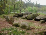
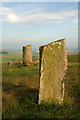
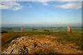
Canmore ID 57162 tells us that 'The Cow Stone' is the local name given to this stone, which has been "evidently split from an outcrop". It stands 380 yards downhill from The Brother's Stones, which sit on the summit of the hill and can be clearly seen from The Cow Stone.
Also known as Brotherstone Hill Prehistoric Standing Stone, and irregular in shape, it measures approximately 2 metres in height and 2 metres in width, and has packing stones around its base to keep the stone secure.
Canmore report that: "this standing stone may have formed part of a larger complex of ceremonial monuments which included the nearby 'Brothers' Stones'. It was probably erected in the third or second millennium BC."
You may be viewing yesterday's version of this page. To see the most up to date information please register for a free account.
 (PID:8871)")
 (PID:8886)")
Do not use the above information on other web sites or publications without permission of the contributor.
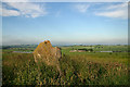
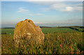
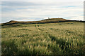
Nearby Images from Geograph Britain and Ireland:
©2009(licence)
©2009(licence)
©2009(licence)
©2009(licence)
©2009(licence)
The above images may not be of the site on this page, they are loaded from Geograph.
Please Submit an Image of this site or go out and take one for us!
Click here to see more info for this site
Nearby sites
Key: Red: member's photo, Blue: 3rd party photo, Yellow: other image, Green: no photo - please go there and take one, Grey: site destroyed
Download sites to:
KML (Google Earth)
GPX (GPS waypoints)
CSV (Garmin/Navman)
CSV (Excel)
To unlock full downloads you need to sign up as a Contributory Member. Otherwise downloads are limited to 50 sites.
Turn off the page maps and other distractions
Nearby sites listing. In the following links * = Image available
327m SW 232° Brothers' Stones* Standing Stones (NT61903600)
4.3km NW 324° Purveshaugh* Standing Stone (Menhir) (NT59663973)
4.4km S 187° Mertoun Kirk (St Boswells)* Sculptured Stone (NT6155231821)
4.5km SW 215° Font Stone (Dryburgh)* Ancient Cross (NT59543258)
5.4km WSW 250° Trimontium* Ancient Village or Settlement (NT57033435)
5.6km SSW 195° Crystal Well (Benrig)* Holy Well or Sacred Spring (NT6064030847)
5.9km SSW 195° St Boswell's Old Church* Ancient Cross (NT6063730533)
6.0km SSW 194° Hier Well (Benrig)* Holy Well or Sacred Spring (NT60703042)
6.1km S 187° Maxton Burgh (St Boswells)* Ancient Cross (NT61333020)
6.2km WSW 245° Rhymer's Stone (Melrose)* Marker Stone (NT5651833592)
7.0km SE 132° The Law (Scottish Borders) Artificial Mound (NT6735831447)
7.5km WSW 243° Eildon Hill North* Hillfort (NT55453280)
8.9km SSE 149° Fairnington Stone Circle (NT667285)
10.3km S 172° Harrietsfield Standing Stone (Menhir) (NT63442599)
10.8km E 83° Piper's Grave Cists Cist (NT72923739)
10.9km NNW 338° Dods Corse Stone (Boon)* Ancient Cross (NT58214633)
11.3km SSE 167° Woodside (Crailing) Standing Stone (Menhir) (NT64552517)
11.3km S 178° Castle Hill (Ancrum)* Hillfort (NT6239424909)
11.3km S 180° Ancrum Old Church* Sculptured Stone (NT6215024885)
11.7km SSE 153° Nisbet 2* Sculptured Stone (NT67322572)
12.3km S 171° Harestanes (Ancrum) Stone Circle (NT640240)
12.3km S 170° Harestanes (Ancrum) Stone Circle (NT641240)
12.6km NNW 342° Cambridge Standing Stone* Standing Stone (Menhir) (NT58434826)
12.9km NNE 19° Harelaw* Misc. Earthwork (NT66444834)
12.9km WNW 288° Hawksnest (Langshaw) Ring Cairn (NT499403)
View more nearby sites and additional images


 We would like to know more about this location. Please feel free to add a brief description and any relevant information in your own language.
 Wir möchten mehr über diese Stätte erfahren. Bitte zögern Sie nicht, eine kurze Beschreibung und relevante Informationen in Deutsch hinzuzufügen.
 Nous aimerions en savoir encore un peu sur les lieux. S'il vous plaît n'hesitez pas à ajouter une courte description et tous les renseignements pertinents dans votre propre langue.
 Quisieramos informarnos un poco más de las lugares. No dude en añadir una breve descripción y otros datos relevantes en su propio idioma.