<< Our Photo Pages >> Brothers' Stones - Standing Stones in Scotland in Scottish Borders
Submitted by cosmic on Sunday, 22 December 2002 Page Views: 11885
Neolithic and Bronze AgeSite Name: Brothers' Stones Alternative Name: Brotherstone HillCountry: Scotland County: Scottish Borders Type: Standing Stones
Nearest Town: Melrose Nearest Village: Smailholm
Map Ref: NT61903600 Landranger Map Number: 74
Latitude: 55.616090N Longitude: 2.606456W
Condition:
| 5 | Perfect |
| 4 | Almost Perfect |
| 3 | Reasonable but with some damage |
| 2 | Ruined but still recognisable as an ancient site |
| 1 | Pretty much destroyed, possibly visible as crop marks |
| 0 | No data. |
| -1 | Completely destroyed |
| 5 | Superb |
| 4 | Good |
| 3 | Ordinary |
| 2 | Not Good |
| 1 | Awful |
| 0 | No data. |
| 5 | Can be driven to, probably with disabled access |
| 4 | Short walk on a footpath |
| 3 | Requiring a bit more of a walk |
| 2 | A long walk |
| 1 | In the middle of nowhere, a nightmare to find |
| 0 | No data. |
| 5 | co-ordinates taken by GPS or official recorded co-ordinates |
| 4 | co-ordinates scaled from a detailed map |
| 3 | co-ordinates scaled from a bad map |
| 2 | co-ordinates of the nearest village |
| 1 | co-ordinates of the nearest town |
| 0 | no data |
Internal Links:
External Links:
I have visited· I would like to visit
bishop_pam visited on 22nd Aug 2017 - their rating: Cond: 4 Amb: 4 Access: 3
")
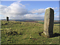
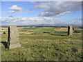
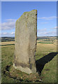
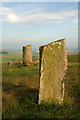
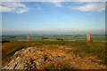
The Brothers' Stones occupy a prominent position on the summit of Brotherstone Hill. The SE stone is the larger at 2.5m while 14m (15 yards) away is just under 2m high. To the east but visible in one of the photos is the Cow Stone.
Further information can be found on Canmore ID 57173 which gives two grid references for the stones: NT 6190 3600 and NT 6189 3601. Text from Accessing Scotland's Past recorded on this Canmore record tells us: "Two standing stones, known as the 'Brothers' Stones', occupy a prominent position on the summit of Brotherstone Hill. They appear to be aligned with a third standing stone - the 'Cow Stone' - which lies farther down the slope of the hill to the north-east, some 380m away. The south-east stone is the larger of the two, rising to a height of about 2.5m. It stands 14m away from the smaller stone, which is just under 2m in height. Both have packing stones around their bases. These standing stones were probably contemporary with the nearby 'Cow Stone'. Together, these standing stones formed a larger complex of ceremonial monuments probably dating to the third or second millennium BC."
You may be viewing yesterday's version of this page. To see the most up to date information please register for a free account.
")
")
")
Do not use the above information on other web sites or publications without permission of the contributor.
Nearby Images from Geograph Britain and Ireland:
©2006(licence)
©2006(licence)
©2006(licence)
©2009(licence)
©2009(licence)
The above images may not be of the site on this page, they are loaded from Geograph.
Please Submit an Image of this site or go out and take one for us!
Click here to see more info for this site
Nearby sites
Key: Red: member's photo, Blue: 3rd party photo, Yellow: other image, Green: no photo - please go there and take one, Grey: site destroyed
Download sites to:
KML (Google Earth)
GPX (GPS waypoints)
CSV (Garmin/Navman)
CSV (Excel)
To unlock full downloads you need to sign up as a Contributory Member. Otherwise downloads are limited to 50 sites.
Turn off the page maps and other distractions
Nearby sites listing. In the following links * = Image available
327m NE 52° Cow Stone (Scottish Borders)* Standing Stone (Menhir) (NT62163620)
4.1km SW 214° Font Stone (Dryburgh)* Ancient Cross (NT59543258)
4.2km S 184° Mertoun Kirk (St Boswells)* Sculptured Stone (NT6155231821)
4.3km NNW 329° Purveshaugh* Standing Stone (Menhir) (NT59663973)
5.1km WSW 251° Trimontium* Ancient Village or Settlement (NT57033435)
5.3km SSW 193° Crystal Well (Benrig)* Holy Well or Sacred Spring (NT6064030847)
5.6km SSW 192° St Boswell's Old Church* Ancient Cross (NT6063730533)
5.7km SSW 192° Hier Well (Benrig)* Holy Well or Sacred Spring (NT60703042)
5.8km S 185° Maxton Burgh (St Boswells)* Ancient Cross (NT61333020)
5.9km WSW 245° Rhymer's Stone (Melrose)* Marker Stone (NT5651833592)
7.1km SE 129° The Law (Scottish Borders) Artificial Mound (NT6735831447)
7.2km WSW 243° Eildon Hill North* Hillfort (NT55453280)
8.9km SSE 147° Fairnington Stone Circle (NT667285)
10.1km S 171° Harrietsfield Standing Stone (Menhir) (NT63442599)
11.0km NNW 340° Dods Corse Stone (Boon)* Ancient Cross (NT58214633)
11.1km E 82° Piper's Grave Cists Cist (NT72923739)
11.1km S 177° Castle Hill (Ancrum)* Hillfort (NT6239424909)
11.1km S 178° Ancrum Old Church* Sculptured Stone (NT6215024885)
11.1km SSE 166° Woodside (Crailing) Standing Stone (Menhir) (NT64552517)
11.6km SSE 152° Nisbet 2 Sculptured Stone (NT67322572)
12.2km S 170° Harestanes (Ancrum) Stone Circle (NT640240)
12.2km S 169° Harestanes (Ancrum) Stone Circle (NT641240)
12.7km WNW 289° Hawksnest (Langshaw) Ring Cairn (NT499403)
12.7km NNW 344° Cambridge Standing Stone* Standing Stone (Menhir) (NT58434826)
13.1km NNE 20° Harelaw* Misc. Earthwork (NT66444834)
View more nearby sites and additional images


 We would like to know more about this location. Please feel free to add a brief description and any relevant information in your own language.
 Wir möchten mehr über diese Stätte erfahren. Bitte zögern Sie nicht, eine kurze Beschreibung und relevante Informationen in Deutsch hinzuzufügen.
 Nous aimerions en savoir encore un peu sur les lieux. S'il vous plaît n'hesitez pas à ajouter une courte description et tous les renseignements pertinents dans votre propre langue.
 Quisieramos informarnos un poco más de las lugares. No dude en añadir una breve descripción y otros datos relevantes en su propio idioma.