 with our Megalithic Portal iPhone app")


<< Our Photo Pages >> Burwalls Camp - Promontory Fort / Cliff Castle in England in Somerset
Submitted by TheCaptain on Friday, 19 August 2011 Page Views: 7916
Iron Age and Later PrehistorySite Name: Burwalls Camp Alternative Name: Burgh Walls, Borough Walls, Bowre WallsCountry: England
NOTE: This site is 0.2 km away from the location you searched for.
County: Somerset Type: Promontory Fort / Cliff Castle
Nearest Town: Bristol Nearest Village: Clifton
Map Ref: ST562730
Latitude: 51.454276N Longitude: 2.631752W
Condition:
| 5 | Perfect |
| 4 | Almost Perfect |
| 3 | Reasonable but with some damage |
| 2 | Ruined but still recognisable as an ancient site |
| 1 | Pretty much destroyed, possibly visible as crop marks |
| 0 | No data. |
| -1 | Completely destroyed |
| 5 | Superb |
| 4 | Good |
| 3 | Ordinary |
| 2 | Not Good |
| 1 | Awful |
| 0 | No data. |
| 5 | Can be driven to, probably with disabled access |
| 4 | Short walk on a footpath |
| 3 | Requiring a bit more of a walk |
| 2 | A long walk |
| 1 | In the middle of nowhere, a nightmare to find |
| 0 | No data. |
| 5 | co-ordinates taken by GPS or official recorded co-ordinates |
| 4 | co-ordinates scaled from a detailed map |
| 3 | co-ordinates scaled from a bad map |
| 2 | co-ordinates of the nearest village |
| 1 | co-ordinates of the nearest town |
| 0 | no data |
Internal Links:
External Links:
I have visited· I would like to visit
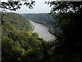
TheCaptain visited on 28th Aug 2011 - their rating: Cond: 2 Amb: 4 Access: 5 The Burwalls Camp hillfort is one of three iron age forts here probably guarding a ford crossing of the river Avon at the bottom of the Avon Gorge, below where is now the Clifton Suspension Bridge. Now mostly destroyed, with the western end of the Clifton Bridge and massive houses built all over it, a few remnants of the original ramparts can still be seen among the gardens of Burwalls. The neighbouring forts are Stokeleigh camp, just across Nightingale Valley, also on the western side of the Avon Gorge, and Clifton Down Camp on the eastern, Clifton side.
lboutside visited - their rating: Cond: 2 Amb: 3 Access: 4
hevveh have visited here
Average ratings for this site from all visit loggers: Condition: 2 Ambience: 3.5 Access: 4.5
")
Now mostly destroyed, with the western end of the Clifton Bridge and massive houses built all over it, a few remnants of the original ramparts can still be seen among the gardens of Burwalls.
The neighbouring forts are Stokeleigh camp, just across Nightingale Valley, also on the western side of the Avon Gorge, and Clifton Down Camp on the eastern, Clifton side.
You may be viewing yesterday's version of this page. To see the most up to date information please register for a free account.
")
Do not use the above information on other web sites or publications without permission of the contributor.
TheCaptain has found this location on Google Street View:
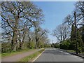
Nearby Images from Geograph Britain and Ireland:
©2006(licence)
©2022(licence)
©2017(licence)
©2022(licence)
©2021(licence)
The above images may not be of the site on this page, they are loaded from Geograph.
Please Submit an Image of this site or go out and take one for us!
Click here to see more info for this site
Nearby sites
Key: Red: member's photo, Blue: 3rd party photo, Yellow: other image, Green: no photo - please go there and take one, Grey: site destroyed
Download sites to:
KML (Google Earth)
GPX (GPS waypoints)
CSV (Garmin/Navman)
CSV (Excel)
To unlock full downloads you need to sign up as a Contributory Member. Otherwise downloads are limited to 50 sites.
Turn off the page maps and other distractions
Nearby sites listing. In the following links * = Image available
360m NW 326° Stokeleigh Camp* Promontory Fort / Cliff Castle (ST560733)
477m NE 52° Clifton Down Camp* Hillfort (ST56587329)
1.9km E 83° Bristol City Museum* Museum (ST58057321)
2.0km WNW 300° Abbots Leigh Churchyard Cross* Ancient Cross (ST5445274007)
2.2km ENE 66° Bewells Cross* Ancient Cross (ST5822673871)
2.2km SSW 201° Long Ashton Cross* Ancient Cross (ST5539070910)
2.6km NE 42° Redland Park* Standing Stone (Menhir) (ST57947492)
2.9km W 271° Snake's Well and Spring* Holy Well or Sacred Spring (ST53287308)
3.2km N 358° Druid Stoke* Chambered Tomb (ST56107620)
4.2km ENE 78° Armoury Square Standing Stone (Menhir) (ST60287386)
4.3km WSW 255° Wraxall Camp* Ancient Village or Settlement (ST52057193)
4.9km NNW 338° Bewys Cross* Ancient Cross (ST5436877571)
5.0km NNW 347° King's Weston Hill barrow cemetary* Barrow Cemetery (ST55127793)
5.1km N 351° King's Weston Hill stockpound* Misc. Earthwork (ST55417807)
5.2km N 353° King's Weston Hillfort* Hillfort (ST55597813)
5.2km NNE 19° Southmead Barrow* Round Barrow(s) (ST5794477902)
5.3km SSW 214° Fairy Well (Barrow Gurney) Holy Well or Sacred Spring (ST532686)
5.4km N 356° Blaise Castle* Hillfort (ST55857837)
6.0km E 94° St Ann's Well (Brislington)* Holy Well or Sacred Spring (ST6217472515)
6.1km E 83° Don Johns Cross* Ancient Cross (ST6229873640)
6.4km WNW 291° Portbury* Standing Stone (Menhir) (ST50277538)
6.6km SW 236° Flax Bourton Ancient Cross* Ancient Cross (ST5066269369)
6.6km WNW 288° Conygar Hillfort* Hillfort (ST4989075090)
6.7km NE 49° Stoke Park Long Barrow* Long Barrow (ST6132077294)
6.7km SSE 167° Dundry Long Barrow* Long Barrow (ST57606645)
View more nearby sites and additional images


 We would like to know more about this location. Please feel free to add a brief description and any relevant information in your own language.
 Wir möchten mehr über diese Stätte erfahren. Bitte zögern Sie nicht, eine kurze Beschreibung und relevante Informationen in Deutsch hinzuzufügen.
 Nous aimerions en savoir encore un peu sur les lieux. S'il vous plaît n'hesitez pas à ajouter une courte description et tous les renseignements pertinents dans votre propre langue.
 Quisieramos informarnos un poco más de las lugares. No dude en añadir una breve descripción y otros datos relevantes en su propio idioma.