

<< Our Photo Pages >> Long Stone, Staunton - Standing Stone (Menhir) in England in Gloucestershire
Submitted by hamish on Sunday, 28 March 2004 Page Views: 13904
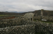
Neolithic and Bronze AgeSite Name: Long Stone, StauntonCountry: England County: Gloucestershire Type: Standing Stone (Menhir)
Nearest Town: Coleford Nearest Village: Staunton
Map Ref: SO55931206 Landranger Map Number: 162
Latitude: 51.805432N Longitude: 2.640567W
Condition:
| 5 | Perfect |
| 4 | Almost Perfect |
| 3 | Reasonable but with some damage |
| 2 | Ruined but still recognisable as an ancient site |
| 1 | Pretty much destroyed, possibly visible as crop marks |
| 0 | No data. |
| -1 | Completely destroyed |
| 5 | Superb |
| 4 | Good |
| 3 | Ordinary |
| 2 | Not Good |
| 1 | Awful |
| 0 | No data. |
| 5 | Can be driven to, probably with disabled access |
| 4 | Short walk on a footpath |
| 3 | Requiring a bit more of a walk |
| 2 | A long walk |
| 1 | In the middle of nowhere, a nightmare to find |
| 0 | No data. |
| 5 | co-ordinates taken by GPS or official recorded co-ordinates |
| 4 | co-ordinates scaled from a detailed map |
| 3 | co-ordinates scaled from a bad map |
| 2 | co-ordinates of the nearest village |
| 1 | co-ordinates of the nearest town |
| 0 | no data |
Internal Links:
External Links:
I have visited· I would like to visit
SumDoood MegalithicChaton would like to visit
bishop_pam visited on 29th Apr 2019 - their rating: Cond: 5 Amb: 4 Access: 5 From the Greenacres campsite we had a lovely walk to this stone through bluebell woods, avoiding traffic on the nearby roads.
4clydesdale7 visited on 14th May 2012 - their rating: Cond: 3 Amb: 3 Access: 5 One of the easier sites to find in the Forest of Dean this stone stands some 8ft high
Humbucker TheCaptain hamish Geojazz have visited here
Average ratings for this site from all visit loggers: Condition: 4 Ambience: 3.5 Access: 5
")
It is said that if you prick this stone at midnight it bleeds.
You may be viewing yesterday's version of this page. To see the most up to date information please register for a free account.
")
")
")
")
")
")
")
")
")
")
")
")
")
")
")
")
")
")
")
Do not use the above information on other web sites or publications without permission of the contributor.
Click here to see more info for this site
Nearby sites
Key: Red: member's photo, Blue: 3rd party photo, Yellow: other image, Green: no photo - please go there and take one, Grey: site destroyed
Download sites to:
KML (Google Earth)
GPX (GPS waypoints)
CSV (Garmin/Navman)
CSV (Excel)
To unlock full downloads you need to sign up as a Contributory Member. Otherwise downloads are limited to 50 sites.
Turn off the page maps and other distractions
Nearby sites listing. In the following links * = Image available
1.0km WNW 300° Staunton Cross* Ancient Cross (SO5506412571)
1.2km WNW 287° Brindsey Well* Holy Well or Sacred Spring (SO5481712403)
1.4km WNW 292° Toads Mouth Stone* Natural Stone / Erratic / Other Natural Feature (SO54621260)
1.4km WNW 297° John The Baptists Well (Staunton)* Holy Well or Sacred Spring (SO5467512722)
1.7km W 274° The Virgins Cup* Natural Stone / Erratic / Other Natural Feature (SO54191219)
1.8km NW 313° Calfs Well* Holy Well or Sacred Spring (SO5465613283)
1.8km W 274° The Buck Stone (Gloucestershire)* Rock Outcrop (SO541122)
2.1km NNW 341° Whipping Brook Cave Cave or Rock Shelter (SO55251410)
2.2km W 279° Staunton Broadstones* Natural Stone / Erratic / Other Natural Feature (SO53741242)
2.5km NNW 342° The Biblins Cave Cave or Rock Shelter (SO55161446)
2.5km NW 320° Near Hearkening Rock* Natural Stone / Erratic / Other Natural Feature (SO54311401)
2.6km NW 318° Staunton Suck Stone (Gloucestershire)* Natural Stone / Erratic / Other Natural Feature (SO54211401)
2.6km SSW 193° Newland Crosses* Ancient Cross (SO5530809511)
3.0km N 349° Biblins Cave or Rock Shelter (SO554150)
3.0km N 352° Lord's Wood Cave Cave or Rock Shelter (SO55551503)
3.2km N 354° Merlin's Cave (Herefordshire) Cave or Rock Shelter (SO55601526)
3.4km N 2° Bowler's Hole Cave or Rock Shelter (SO56101545)
3.4km NNW 338° Madawg Rockshelter* Cave or Rock Shelter (SO54651526)
3.5km N 2° Symonds Yat Cave Cave or Rock Shelter (SO56101555)
3.5km N 2° Wye Rapids Cave Cave or Rock Shelter (SO56101555)
3.5km N 2° Symonds Yat Cave 2 Cave or Rock Shelter (SO56101555)
3.5km N 2° Symonds Yat Cave 3 Cave or Rock Shelter (SO56101555)
3.5km N 356° Symonds Yat West* Cave or Rock Shelter (SO55701555)
3.5km NNW 337° Cavall's Cave* Cave or Rock Shelter (SO546153)
3.5km NNW 329° Far Hearkening Rock* Natural Stone / Erratic / Other Natural Feature (SO5410515107)
View more nearby sites and additional images


 We would like to know more about this location. Please feel free to add a brief description and any relevant information in your own language.
 Wir möchten mehr über diese Stätte erfahren. Bitte zögern Sie nicht, eine kurze Beschreibung und relevante Informationen in Deutsch hinzuzufügen.
 Nous aimerions en savoir encore un peu sur les lieux. S'il vous plaît n'hesitez pas à ajouter une courte description et tous les renseignements pertinents dans votre propre langue.
 Quisieramos informarnos un poco más de las lugares. No dude en añadir una breve descripción y otros datos relevantes en su propio idioma.