<< Our Photo Pages >> Dingieshowe - Ancient Village or Settlement in Scotland in Orkney
Submitted by howar on Sunday, 11 December 2005 Page Views: 7354
Multi-periodSite Name: Dingieshowe Alternative Name: Dingishowe, Dingy's Howe, Dingy's-how, Duncan's-heCountry: Scotland County: Orkney Type: Ancient Village or Settlement
Nearest Town: Kirkwall Nearest Village: Toab
Map Ref: HY54760330
Latitude: 58.914593N Longitude: 2.787211W
Condition:
| 5 | Perfect |
| 4 | Almost Perfect |
| 3 | Reasonable but with some damage |
| 2 | Ruined but still recognisable as an ancient site |
| 1 | Pretty much destroyed, possibly visible as crop marks |
| 0 | No data. |
| -1 | Completely destroyed |
| 5 | Superb |
| 4 | Good |
| 3 | Ordinary |
| 2 | Not Good |
| 1 | Awful |
| 0 | No data. |
| 5 | Can be driven to, probably with disabled access |
| 4 | Short walk on a footpath |
| 3 | Requiring a bit more of a walk |
| 2 | A long walk |
| 1 | In the middle of nowhere, a nightmare to find |
| 0 | No data. |
| 5 | co-ordinates taken by GPS or official recorded co-ordinates |
| 4 | co-ordinates scaled from a detailed map |
| 3 | co-ordinates scaled from a bad map |
| 2 | co-ordinates of the nearest village |
| 1 | co-ordinates of the nearest town |
| 0 | no data |
Internal Links:
External Links:
I have visited· I would like to visit
whese001 would like to visit
Redfun has visited here
")
Dingieshowe, HY50SW 7, was considered part of a bigger settlement at the end of the 18th century as they considered the stony hillocks beneath the present sand dunes between here and Deerness to have been buildings also. The broch mound still stands over seven metres high but Petrie and Farrer in 1860 only found a building six feet high on the sandy knoll, finding clay and partially vitrified sand ('cramp') beneath the floor that would seem to rule any continuance of this round house below. Only late pottery was found, so this looks like re-use of an earlier structure - evidence of widespread burning beneath the foundations seen as evidence of sacrifice being perhaps reason for prior abandonment instead (the collection included fragments of Corded Ware). Unofficial digging in the 1920s exposed a short length of drystone wall/ing and a kitchen midden south side. In 1964 deposits of shell were seen on both S and W slopes. What looks to be a bank at the north to northwest may only be from sand quarrying.
Coming to the broch by the farmroad is easiest as there is a kind of platform there. I think the short wall-sections are gardenification like that which 'lost' us Peerie Howe further along the track. From this side you see a large excavation on the side of the broch (unfortunately all the areas of digging are now covered by turf or. on the east a sea of grassy tussocks) and a kind of grassy track up the side. On top the interior is all hollowed out. Looking over to the left is a distinct rectangular hollow. If not simply a later excavation pit this looks a likely intramural feature, either a chamber or the beginning of a stair. At the seaward side are further excavation traces. Apart from the flat 'platform' trackside the rest of the mound drops away in front of you (perhaps the mound was once at the end of a distinct tongue of land). At the other side is another track going down, narrower and sharper and steeper. From the bottom there is the sense of ditches or banks between broch and the first sandy hillocks.
Presuming that the tracks from the farmroad to the dunes are 'modern' there is a likelihood that anything proceeding the late broch structure will be be connected with Peerie Howe. Though because of burnt stones in the latter it has been seen as a burnt mound it strikes me as possible that it was subject to the same environmental catastrophe seen at the broch site viz. signs of a major conflagration. Could the stony hillocks reported in the Orkney Statistical Account include the area that became a gravel quarry ? And what of the shell-midden at the cliff base just past this, below Sandaiken ??
You may be viewing yesterday's version of this page. To see the most up to date information please register for a free account.
")
")
Do not use the above information on other web sites or publications without permission of the contributor.
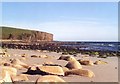
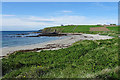
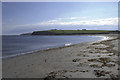
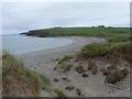
Nearby Images from Geograph Britain and Ireland:
©2009(licence)
©2018(licence)

©2015(licence)
©2013(licence)
©2011(licence)
The above images may not be of the site on this page, they are loaded from Geograph.
Please Submit an Image of this site or go out and take one for us!
Click here to see more info for this site
Nearby sites
Key: Red: member's photo, Blue: 3rd party photo, Yellow: other image, Green: no photo - please go there and take one, Grey: site destroyed
Download sites to:
KML (Google Earth)
GPX (GPS waypoints)
CSV (Garmin/Navman)
CSV (Excel)
To unlock full downloads you need to sign up as a Contributory Member. Otherwise downloads are limited to 50 sites.
Turn off the page maps and other distractions
Nearby sites listing. In the following links * = Image available
61m S 189° Peerie Howe* Ancient Village or Settlement (HY54750324)
638m ENE 75° Sandaiken* Ancient Village or Settlement (HY55380346)
1.0km NW 315° Comely* Cairn (HY54040403)
1.1km SW 214° Stembister farm stone* Standing Stone (Menhir) (HY54130239)
1.4km NW 310° Campston Cairn* Cairn (HY537042)
1.4km SW 220° The Cairn* Artificial Mound (HY53840223)
1.5km NW 307° St. Peter's Kirk* Ancient Village or Settlement (HY536042)
1.6km NW 318° St. Peter's Bay Mound* Broch or Nuraghe (HY537045)
1.9km ENE 77° Mussaquoy* Artificial Mound (HY56590369)
2.1km WNW 292° Campston (Toab)* Broch or Nuraghe (HY528041)
2.8km N 2° Eves Howe* Broch or Nuraghe (HY54900611)
2.8km ENE 72° Newark (Orkney)* Souterrain (Fogou, Earth House) (HY57460413)
3.0km N 354° Hurnip's Point* Chambered Cairn (HY54480634)
3.3km ENE 77° Howe o' Backland* Broch or Nuraghe (HY58040402)
3.6km NE 40° Howan Blo* Cist (HY571060)
3.9km NW 314° Breck Farm* Standing Stones (HY520060)
4.0km NNE 28° Millfield* Artificial Mound (HY56700682)
4.3km NNE 30° Koffer Howe* Artificial Mound (HY56920699)
4.5km SW 228° Castle Howe (Orkney)* Ancient Village or Settlement (HY514003)
4.5km NW 308° Longhowe Cairn (HY512061)
4.6km NW 317° Muckle Crofty* Stone Row / Alignment (HY517067)
4.6km NW 306° Mine Howe* Chambered Cairn (HY5106406023)
4.6km SW 234° St. Nicholas Church* Ancient Village or Settlement (HY510006)
4.6km ENE 61° The Howie* Ancient Village or Settlement (HY58850550)
4.6km SSW 207° Roseness* Chambered Cairn (ND52629917)
View more nearby sites and additional images


 We would like to know more about this location. Please feel free to add a brief description and any relevant information in your own language.
 Wir möchten mehr über diese Stätte erfahren. Bitte zögern Sie nicht, eine kurze Beschreibung und relevante Informationen in Deutsch hinzuzufügen.
 Nous aimerions en savoir encore un peu sur les lieux. S'il vous plaît n'hesitez pas à ajouter une courte description et tous les renseignements pertinents dans votre propre langue.
 Quisieramos informarnos un poco más de las lugares. No dude en añadir una breve descripción y otros datos relevantes en su propio idioma.