<< Our Photo Pages >> Newark (Orkney) - Souterrain (Fogou, Earth House) in Scotland in Orkney
Submitted by howar on Wednesday, 02 May 2007 Page Views: 9154
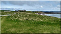
Iron Age and Later PrehistorySite Name: Newark (Orkney)Country: Scotland County: Orkney Type: Souterrain (Fogou, Earth House)
Nearest Town: Kirkwall Nearest Village: Deerness
Map Ref: HY57460413
Latitude: 58.922323N Longitude: 2.740496W
Condition:
| 5 | Perfect |
| 4 | Almost Perfect |
| 3 | Reasonable but with some damage |
| 2 | Ruined but still recognisable as an ancient site |
| 1 | Pretty much destroyed, possibly visible as crop marks |
| 0 | No data. |
| -1 | Completely destroyed |
| 5 | Superb |
| 4 | Good |
| 3 | Ordinary |
| 2 | Not Good |
| 1 | Awful |
| 0 | No data. |
| 5 | Can be driven to, probably with disabled access |
| 4 | Short walk on a footpath |
| 3 | Requiring a bit more of a walk |
| 2 | A long walk |
| 1 | In the middle of nowhere, a nightmare to find |
| 0 | No data. |
| 5 | co-ordinates taken by GPS or official recorded co-ordinates |
| 4 | co-ordinates scaled from a detailed map |
| 3 | co-ordinates scaled from a bad map |
| 2 | co-ordinates of the nearest village |
| 1 | co-ordinates of the nearest town |
| 0 | no data |
Internal Links:
External Links:
I have visited· I would like to visit
whese001 would like to visit
 (PID:29630)")
Mainly known as the site of the 16th century Neu Wark of Deerness and a Norse chapel dated to the 10th, but there were two souterrains found beneath the latter. Apart from the synopsis for RCAHMS NMRS record no. HY50SE 3 there is next to nothing published. The best source covers only the first two years, but includes dig diaries with plans for 1969-70 by two ex-diggers [http://www.hopkinsweb.org.uk/orkney/index.htm].
There the published souterrain (London Institute of London bulletin 44, which I haven't found) appears as a tunnel that ended up in a chamber, with a skeleton on a ?platform, at about the fifty foot mark i.e. far beyond the chapel itself. The NMRS has it is 10m and described as lying E/W, though the long curving passage is nearer N/S where it exited at the cliff. Looking at a 1969 plan I think the other earth-house is a pillared one like Yinstay, shown as a patch of "bare earth with irregular stones."
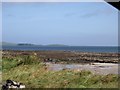
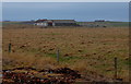
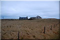
The chapel survives to several courses as the larger of the structures between the present steading and the sea, and the souterrain is open (though partly filled with stones) at the western side of the interior. Its course starts at the back and slews across at a slight angle to the chapel wall. I was unable to see where it comes out the cliff despite knowing the position.
Photos of the entire site, with a goodly portion of the cliff face either side of the main remains, can be found at http://tech.ph.groups.yahoo.com/group/circlesettler/photos. Unfortunately without end of excavation plans I am unable to put names to most features.
You may be viewing yesterday's version of this page. To see the most up to date information please register for a free account.
 (PID:29637)")
Do not use the above information on other web sites or publications without permission of the contributor.
Nearby Images from Geograph Britain and Ireland:
©2005(licence)
©2008(licence)
©2012(licence)
©2008(licence)
©2021(licence)
The above images may not be of the site on this page, they are loaded from Geograph.
Please Submit an Image of this site or go out and take one for us!
Click here to see more info for this site
Nearby sites
Key: Red: member's photo, Blue: 3rd party photo, Yellow: other image, Green: no photo - please go there and take one, Grey: site destroyed
Download sites to:
KML (Google Earth)
GPX (GPS waypoints)
CSV (Garmin/Navman)
CSV (Excel)
To unlock full downloads you need to sign up as a Contributory Member. Otherwise downloads are limited to 50 sites.
Turn off the page maps and other distractions
Nearby sites listing. In the following links * = Image available
588m E 100° Howe o' Backland* Broch or Nuraghe (HY58040402)
972m WSW 242° Mussaquoy* Artificial Mound (HY56590369)
1.9km NNW 348° Howan Blo* Cist (HY571060)
1.9km NE 45° The Howie* Ancient Village or Settlement (HY58850550)
2.2km WSW 251° Sandaiken* Ancient Village or Settlement (HY55380346)
2.5km NNE 31° Deerness Broch or Nuraghe (HY588063)
2.8km NNW 344° Millfield* Artificial Mound (HY56700682)
2.8km WSW 252° Dingieshowe* Ancient Village or Settlement (HY54760330)
2.8km WSW 251° Peerie Howe* Ancient Village or Settlement (HY54750324)
2.9km NNW 349° Koffer Howe* Artificial Mound (HY56920699)
3.2km NW 307° Eves Howe* Broch or Nuraghe (HY54900611)
3.4km W 268° Comely* Cairn (HY54040403)
3.7km NW 306° Hurnip's Point* Chambered Cairn (HY54480634)
3.7km NNE 27° Riggan of Kami* Broch or Nuraghe (HY59170743)
3.7km WSW 242° Stembister farm stone* Standing Stone (Menhir) (HY54130239)
3.7km W 270° Campston Cairn* Cairn (HY537042)
3.8km W 275° St. Peter's Bay Mound* Broch or Nuraghe (HY537045)
3.8km W 270° St. Peter's Kirk* Ancient Village or Settlement (HY536042)
4.1km WSW 242° The Cairn* Artificial Mound (HY53840223)
4.6km W 269° Campston (Toab)* Broch or Nuraghe (HY528041)
5.0km NNE 24° Brough of Deerness* Promontory Fort / Cliff Castle (HY59550873)
5.8km WNW 288° Breck Farm* Standing Stones (HY520060)
6.3km WNW 293° Muckle Crofty* Stone Row / Alignment (HY517067)
6.4km WNW 299° Loch of Messigate* Standing Stones (HY519073)
6.5km WNW 287° Longhowe Cairn (HY512061)
View more nearby sites and additional images


 We would like to know more about this location. Please feel free to add a brief description and any relevant information in your own language.
 Wir möchten mehr über diese Stätte erfahren. Bitte zögern Sie nicht, eine kurze Beschreibung und relevante Informationen in Deutsch hinzuzufügen.
 Nous aimerions en savoir encore un peu sur les lieux. S'il vous plaît n'hesitez pas à ajouter une courte description et tous les renseignements pertinents dans votre propre langue.
 Quisieramos informarnos un poco más de las lugares. No dude en añadir una breve descripción y otros datos relevantes en su propio idioma.