<< Our Photo Pages >> The Buck Stone (Gloucestershire) - Rock Outcrop in England in Gloucestershire
Submitted by PhilKidderminster on Saturday, 05 March 2011 Page Views: 12352
Natural PlacesSite Name: The Buck Stone (Gloucestershire)Country: England County: Gloucestershire Type: Rock Outcrop
Nearest Town: Monmouth Nearest Village: Staunton
Map Ref: SO541122
Latitude: 51.806543N Longitude: 2.667125W
Condition:
| 5 | Perfect |
| 4 | Almost Perfect |
| 3 | Reasonable but with some damage |
| 2 | Ruined but still recognisable as an ancient site |
| 1 | Pretty much destroyed, possibly visible as crop marks |
| 0 | No data. |
| -1 | Completely destroyed |
| 5 | Superb |
| 4 | Good |
| 3 | Ordinary |
| 2 | Not Good |
| 1 | Awful |
| 0 | No data. |
| 5 | Can be driven to, probably with disabled access |
| 4 | Short walk on a footpath |
| 3 | Requiring a bit more of a walk |
| 2 | A long walk |
| 1 | In the middle of nowhere, a nightmare to find |
| 0 | No data. |
| 5 | co-ordinates taken by GPS or official recorded co-ordinates |
| 4 | co-ordinates scaled from a detailed map |
| 3 | co-ordinates scaled from a bad map |
| 2 | co-ordinates of the nearest village |
| 1 | co-ordinates of the nearest town |
| 0 | no data |
Internal Links:
External Links:
I have visited· I would like to visit
MegalithicChaton would like to visit
4clydesdale7 visited on 9th Jun 2012 - their rating: Cond: 3 Amb: 4 Access: 3 Great Views - big stone
fibo74 visited - their rating: Cond: 5 Amb: 5 Access: 3
Geojazz have visited here
Average ratings for this site from all visit loggers: Condition: 4 Ambience: 4.5 Access: 3
 (PID:74197)")
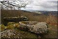
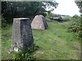
Naturally occurring rock which originally rocked, but after an accident in the nineteenth century was cemented in place.
You may be viewing yesterday's version of this page. To see the most up to date information please register for a free account.
 (PID:74338)")
 (PID:144568)")
Do not use the above information on other web sites or publications without permission of the contributor.
Nearby Images from Geograph Britain and Ireland:

©2013(licence)
©2008(licence)

©2008(licence)
©2013(licence)

©2024(licence)
The above images may not be of the site on this page, they are loaded from Geograph.
Please Submit an Image of this site or go out and take one for us!
Click here to see more info for this site
Nearby sites
Key: Red: member's photo, Blue: 3rd party photo, Yellow: other image, Green: no photo - please go there and take one, Grey: site destroyed
Download sites to:
KML (Google Earth)
GPX (GPS waypoints)
CSV (Garmin/Navman)
CSV (Excel)
To unlock full downloads you need to sign up as a Contributory Member. Otherwise downloads are limited to 50 sites.
Turn off the page maps and other distractions
Nearby sites listing. In the following links * = Image available
90m E 96° The Virgins Cup* Natural Stone / Erratic / Other Natural Feature (SO54191219)
421m WNW 301° Staunton Broadstones* Natural Stone / Erratic / Other Natural Feature (SO53741242)
655m NE 52° Toads Mouth Stone* Natural Stone / Erratic / Other Natural Feature (SO54621260)
743m ENE 74° Brindsey Well* Holy Well or Sacred Spring (SO5481712403)
775m NE 47° John The Baptists Well (Staunton)* Holy Well or Sacred Spring (SO5467512722)
1.0km ENE 68° Staunton Cross* Ancient Cross (SO5506412571)
1.8km N 3° Staunton Suck Stone (Gloucestershire)* Natural Stone / Erratic / Other Natural Feature (SO54211401)
1.8km N 6° Near Hearkening Rock* Natural Stone / Erratic / Other Natural Feature (SO54311401)
1.8km E 94° Long Stone, Staunton* Standing Stone (Menhir) (SO55931206)
2.1km WNW 286° Kymin Hill Hillfort (SO521128)
2.2km NNE 31° Whipping Brook Cave Cave or Rock Shelter (SO55251410)
2.4km SW 231° Penallt Churchyard Cross* Ancient Cross (SO5220010720)
2.5km NNE 25° The Biblins Cave Cave or Rock Shelter (SO55161446)
2.9km N 360° Far Hearkening Rock* Natural Stone / Erratic / Other Natural Feature (SO5410515107)
2.9km SSE 155° Newland Crosses* Ancient Cross (SO5530809511)
3.1km NNE 24° Biblins Cave or Rock Shelter (SO554150)
3.1km N 10° Madawg Rockshelter Cave or Rock Shelter (SO54651526)
3.1km N 9° Cavall's Cave Cave or Rock Shelter (SO546153)
3.2km NNE 27° Lord's Wood Cave Cave or Rock Shelter (SO55551503)
3.4km N 7° King Arthur's Cave* Cave or Rock Shelter (SO54561559)
3.4km N 8° King Arthur's North* Cave or Rock Shelter (SO54601559)
3.4km NNE 25° Merlin's Cave (Herefordshire) Cave or Rock Shelter (SO556153)
3.6km SW 224° Peny Garn Cross Base* Ancient Cross (SO5158909643)
3.7km NNE 25° Symonds Yat West Cave or Rock Shelter (SO55701555)
3.8km N 358° Little Doward* Hillfort (SO5416)
View more nearby sites and additional images


 We would like to know more about this location. Please feel free to add a brief description and any relevant information in your own language.
 Wir möchten mehr über diese Stätte erfahren. Bitte zögern Sie nicht, eine kurze Beschreibung und relevante Informationen in Deutsch hinzuzufügen.
 Nous aimerions en savoir encore un peu sur les lieux. S'il vous plaît n'hesitez pas à ajouter une courte description et tous les renseignements pertinents dans votre propre langue.
 Quisieramos informarnos un poco más de las lugares. No dude en añadir una breve descripción y otros datos relevantes en su propio idioma.