<< Our Photo Pages >> Burroughston Broch - Broch or Nuraghe in Scotland in Orkney
Submitted by C_Michael_Hogan on Sunday, 07 October 2007 Page Views: 18666
Iron Age and Later PrehistorySite Name: Burroughston BrochCountry: Scotland County: Orkney Type: Broch or Nuraghe
Nearest Town: Kirkwall Nearest Village: Tuskerbister
Map Ref: HY540210 Landranger Map Number: 6
Latitude: 59.073449N Longitude: 2.804103W
Condition:
| 5 | Perfect |
| 4 | Almost Perfect |
| 3 | Reasonable but with some damage |
| 2 | Ruined but still recognisable as an ancient site |
| 1 | Pretty much destroyed, possibly visible as crop marks |
| 0 | No data. |
| -1 | Completely destroyed |
| 5 | Superb |
| 4 | Good |
| 3 | Ordinary |
| 2 | Not Good |
| 1 | Awful |
| 0 | No data. |
| 5 | Can be driven to, probably with disabled access |
| 4 | Short walk on a footpath |
| 3 | Requiring a bit more of a walk |
| 2 | A long walk |
| 1 | In the middle of nowhere, a nightmare to find |
| 0 | No data. |
| 5 | co-ordinates taken by GPS or official recorded co-ordinates |
| 4 | co-ordinates scaled from a detailed map |
| 3 | co-ordinates scaled from a bad map |
| 2 | co-ordinates of the nearest village |
| 1 | co-ordinates of the nearest town |
| 0 | no data |
Internal Links:
External Links:
I have visited· I would like to visit
dharmabum whese001 would like to visit
jeffrep C_Michael_Hogan have visited here
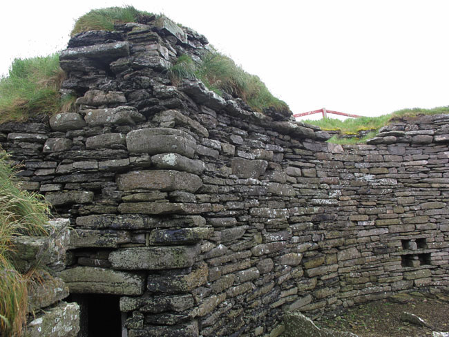
ARCHITECTURE. Burroughston Broch fits within the classic parameters of design among the brochs of the Orkneys, Shetlands and the northern mainland of Scotland. The structure itself is of pure drystone construction, utilizing locally quarried material, which presents in very flat individual stones. While such flat stones are easiest to work for the constructor, the mere bulk of this edifice is testimony to the tens of thousands of man-hours required for its formation. The structure itself suggests an entirely original condition of Iron Age Celtic origin. I base this upon my examination of the obviously unaltered interior lines and rock placement, as well as upon analysis of published and observed geometrics and dimensions of several dozen other Scottish brochs.
This massive towerhouse has an interior diameter of 35 feet, as first published by Petrie, in describing his earliest recorded description of Burroughston Broch (Petrie, 1866) Petrie elaborated that the wall thickness at its front, or easetern, base was approximately 13 feet thick, but the north and south walls diminish to only ten feet, only to have the west wall thickness swell to 14 feet. The height reported by Petrie is 1866 was not given explicitly, but he alludes to extruding rocks at heights of ten to eleven feet. I measured the height in 2007 to vary from about 11 to 13 feet above the interior surface. In any case the upper part of the original tower has been long destroyed, since the height of most Scottish brochs has been estimated be be about 50 feet. (Anderson, 1877) While the lower wall is almost vertical, the complete broch would have been mildly hyperbolic or roundly conical. Based upon a review of 38 brochs in Orkney, Shetland, Caithness, Ross-shire and Invernesshire, I have calculated that the interior ground floor area of Burroughston is 23 percent greater than average.
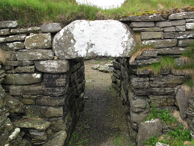
Burroughston Broch has a single entrance passage, with no other apertures even for weapons openings at any point. Within the entrance passage there is an opening on the south side of the passage for a guard chamber, a corbeled stone room of obvious sentry implications. On the ground level there are vestiges of Pictish stone furniture or room divisions, similar to those found in other brochs as well as Pictish neolithic sites such as Skara Brae. In the center of the ground level space is an aperture, which most researchers have described as a well. This is a vertical drystone construction of the same flat stones used for the broch walls. The protrusion of sidewall stones was reminiscent of my descent into Mine Howe; that is to say, the stones were placed in a manner to allow climbing downward. However, groundwater and solid stone basement material was encountered at a depth of approximately 10 feet, making further passage impossible.
I concur with Petrie.s reasoning that the upper (now destroyed level of the broch would have had a double wall containing further cells. I sup port this argument not only by the remnant stone staircase work in the broch interior, and by the knowledge these particular Picts had of building the guard room cell, but by the weathering pattern that appears as though the upper level has been sheared away; that is to say, the upper portion would have been much weaker with a hollow interior for cells.
The outer works of the broch are also impressive, having a concentric design of total diameter 170 feet; these structures may have been added later than the broch itself, and consist of a stone wall approximately 3.5 feet high (the height a warrior might stand behind to defend the broch with his weapon); a rampart of respectible size and a deep moat. The moat (or ‘'fosse'‘ as termed by Petrie) was measured at a bottom width of 15 to 25 feet in the year 1866, but is considerably less as of 2007 with siltation and probable deposition of 19th century excavation work.
AREA FEATURES. Other prehistoric features nearby include the Mor Stein and Odin standing stones, tumuli on higher ground to the southwest and a curious mound known as ‘'Castle Bloody'‘ further south along the coast. A vicinity medieval feature is the ruined Linton Chapel at Linton Bay.
ENVIRONMENTAL FACTORS. No doubt the location of Burroughston was chosen as a defensive lookout for sea marauders coming from other islands or nations. Its position serves well for such a vantage point, and also serve notice on interlopers with its prominence towering on the cliffs, which are approximately eighty feet of sheer rock high above the sea level. The broch is set back roughly 100 feet from the shoreline, sufficient to provide the broch inhabitants a buffer zone from the sea which pound the surrounding lands with salt spray driven by fierce winds during storms. Besides this setback buffer from surf and ocean noise, the situation of Burroughston is much more sheltered from high wave action than the cliff areas to the north; for example, a site selected near the Geo of Ork would have the cliff defences of the Burroughston site, but would be subjected to much higher wave action, making fishing and seal hunting unpromising.
Furthermore Burroughston is situated at a natural cleft or drainage in the coastal cliffs, which aperture allows easy beach access for the broch community to conduct fishing or hunting of the seal colony that still dwells at this specific location on Shapinsay. Walking to the stony beachfront, I noticed the existence of a wide grassy ledge, likely formed by geological slumping before the Picts; this landform allowed sheltered and enhanced viewing along the beach and ocean, an added amenity and resource for this coastal defensive tower community. Perhaps most importantly the broch adjoins fertile lands that are still producing grain crops, as they no doubt did for the Picts inclined to farming at the ancient Burroughston settlement.
Anther environmental factor favouring the selection of this site is the rich seafood resource on the western shores of Shapinsay, within an easy.walk. There are two brackish lochs, Lairo Water and Vasa Loch, respectively 45 minutes and 1.5 hours walk respectively from Burroughston; furthermore there is a productive estuary, the Ouse, adjacent to Lairo Water.
HISTORICAL AND NAMING ISSUES. George Petrie and Sir Henry Dryden were given access and encouragement in their original 1866 work by the owner of Shapinsay Isle, Balfour. The site was disovered as a large grass covered mound, with ensuing excavation carried out on the interior only, leaving to the present day the exterior drystone walls covered with an earthen rampart. In the original publications the fort was called ‘'Burrowston Broch'‘, and the entire site was termed the ‘'Hillock of Burrowston'‘. English influences in the literature over the last 141 years have transformed the dominant spelling to ‘'Burroughston'‘.
REFERENCES. * Geroge Petrie, Corr. Mem. S.A. Scot., F.R.S.N.A. (1866) ‘'Notice of the Brochs or Large Round Towers of Orkney'‘, Proceedings of the Society,. June 11th, 1866 * Joseph Anderson, Keeper of the Museum (1877) ‘'Notes on the Structure, Contents and Distribution of the Brochs'‘, Proceedings of the Society, June 11th, 1877 * Royal Commission for Ancient Historical Monuments (RCAHMS) (2007), ‘'Original Plan and Section Drawing of Borrowston Broch from the 1866 Investigation of Petrie and Dryden, Archive Number SC 338360
(This article is an original work for the Megalithic Portal by C. Michael Hogan)
You may be viewing yesterday's version of this page. To see the most up to date information please register for a free account.


Do not use the above information on other web sites or publications without permission of the contributor.
Click here to see more info for this site
Nearby sites
Key: Red: member's photo, Blue: 3rd party photo, Yellow: other image, Green: no photo - please go there and take one, Grey: site destroyed
Download sites to:
KML (Google Earth)
GPX (GPS waypoints)
CSV (Garmin/Navman)
CSV (Excel)
To unlock full downloads you need to sign up as a Contributory Member. Otherwise downloads are limited to 50 sites.
Turn off the page maps and other distractions
Nearby sites listing. In the following links * = Image available
1.4km NNW 342° Ness of Ork Broch or Nuraghe (HY53562238)
1.9km SW 232° Unyatuak* Artificial Mound (HY52451983)
3.9km WSW 240° Odin Stone* Standing Stone (Menhir) (HY506191)
4.4km SSW 200° Mor Stein* Standing Stone (Menhir) (HY52401685)
4.6km S 185° Castle Bloody* Souterrain (Fogou, Earth House) (HY53581644)
5.7km SSW 209° Howe Hill (Howe Farm)* Ancient Village or Settlement (HY51171599)
6.0km SW 219° Broch of Steiro* Broch or Nuraghe (HY50191635)
6.3km SSW 196° Hacksness (Shapinsay) Cairn (HY52181491)
7.5km SW 225° Helliar Holm Broch or Nuraghe (HY48591579)
8.2km SW 234° Setter Noost* Ancient Village or Settlement (HY47301621)
8.5km NNE 14° Southside (Eday)* Standing Stone (Menhir) (HY56152922)
8.5km NNE 20° Green (Eday)* Ancient Village or Settlement (HY5697128987)
8.5km ENE 67° Hillock of Baywest Broch or Nuraghe (HY61902425)
8.6km SW 236° Twi Ness* Cairn (HY46761625)
8.6km ENE 63° Lochend (Stronsay) Cairn (HY61762487)
9.1km SW 218° Head of Work* Chambered Cairn (HY48341382)
9.1km W 278° Gairsay Cairn (HY44942237)
9.4km NW 315° Onziebist* Chambered Cairn (HY4741827807)
10.8km S 177° Castle of Hangie Bay* Stone Fort or Dun (HY54461022)
10.8km WNW 298° Braes of Ha’Breck, Wyre. Ancient Village or Settlement (HY445262)
10.9km S 177° The Brough* Ancient Village or Settlement (HY545101)
11.1km SSW 196° Yinstay* Ancient Village or Settlement (HY50841031)
11.1km W 268° Holm of Rendall* Cairn (HY4283220735)
11.4km W 264° Knowe of Dishero* Broch or Nuraghe (HY42561998)
11.6km N 9° Eday Manse Cairn (HY56023242)
View more nearby sites and additional images


 We would like to know more about this location. Please feel free to add a brief description and any relevant information in your own language.
 Wir möchten mehr über diese Stätte erfahren. Bitte zögern Sie nicht, eine kurze Beschreibung und relevante Informationen in Deutsch hinzuzufügen.
 Nous aimerions en savoir encore un peu sur les lieux. S'il vous plaît n'hesitez pas à ajouter une courte description et tous les renseignements pertinents dans votre propre langue.
 Quisieramos informarnos un poco más de las lugares. No dude en añadir una breve descripción y otros datos relevantes en su propio idioma.