<< Our Photo Pages >> Midshiels Cairn - Cairn in Scotland in Scottish Borders
Submitted by Anne T on Sunday, 04 June 2017 Page Views: 1356
Neolithic and Bronze AgeSite Name: Midshiels CairnCountry: Scotland County: Scottish Borders Type: Cairn
Nearest Town: Hawick Nearest Village: Midshiels Farm
Map Ref: NT53311770
Latitude: 55.450922N Longitude: 2.739731W
Condition:
| 5 | Perfect |
| 4 | Almost Perfect |
| 3 | Reasonable but with some damage |
| 2 | Ruined but still recognisable as an ancient site |
| 1 | Pretty much destroyed, possibly visible as crop marks |
| 0 | No data. |
| -1 | Completely destroyed |
| 5 | Superb |
| 4 | Good |
| 3 | Ordinary |
| 2 | Not Good |
| 1 | Awful |
| 0 | No data. |
| 5 | Can be driven to, probably with disabled access |
| 4 | Short walk on a footpath |
| 3 | Requiring a bit more of a walk |
| 2 | A long walk |
| 1 | In the middle of nowhere, a nightmare to find |
| 0 | No data. |
| 5 | co-ordinates taken by GPS or official recorded co-ordinates |
| 4 | co-ordinates scaled from a detailed map |
| 3 | co-ordinates scaled from a bad map |
| 2 | co-ordinates of the nearest village |
| 1 | co-ordinates of the nearest town |
| 0 | no data |
Internal Links:
External Links:
I have visited· I would like to visit
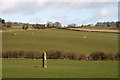
Anne T visited on 29th Aug 2018 - their rating: Cond: 3 Amb: 4 Access: 4 Midshiels Cairn: Having been warned about the large cattle who might "go for us if they saw us", I was cautious about walking the additional 100m from the standing stone to the cairn. Andrew decided that as the cattle were at the far end of the field, and though large, looked relatively docile. “If they come for me I can always leap over the fence (to the railway embankment)”, he said, so I gave him the camera and left to explore the cairn, which seemed much further away than the standing stone, but in reality was only around 90m away.
The Canmore entry of 1948 says the cairn was ‘planted with trees’, although it is now only covered in grass.
Anne T saw from a distance on 3rd Jun 2017 - their rating: Cond: 3 Amb: 4 Access: 4 Midshiels Cairn, Hawick: See visit report for Midshiels Standing Stone (the two are 90 metres apart), sites entered separately as Canmore lists them individually. Couldn't get really close to the cairn - would have loved to have walked up to it, but there was a really big bull and lots of over-friendly and very lively bullocks in the field. Must revisit at a different time of year!
There are plenty of other forts and settlements around here. The problem with another visit, is which sites to pick?
Average ratings for this site from all visit loggers: Condition: 3 Ambience: 4 Access: 4
")
When RCAHMS last visited this site in 1948, they recorded that it was "planted with trees, stands 350 yards north west of Midshiels and at a height of 380ft OD. The cairn measures 85ft in diameter by 10ft in height." For further information see Canmore ID 55253.
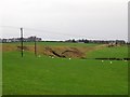
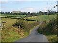
Today there were no trees on the cairn, which lies some 90 metres to the south west of Midshiels Standing Stone. From a distance, the profile of the cairn is irregular and has a dip in the middle. It is also very close to the railway embankment to its west. Canmore suggests that the flattened top of the cairn might indicate the height may have been reduced by about 2ft, indicating it has been disturbed in the past.
In 2098, the cairn (along with the standing stone) was in danger of being damaged by the installation of telegraph poles nearby. See the Hawick News article 'Historian's Race to Preserve Site'.
At the time of our visit, the field was full of young, curious bullocks, so we couldn't get a really close look.
You may be viewing yesterday's version of this page. To see the most up to date information please register for a free account.
")
")
")
Do not use the above information on other web sites or publications without permission of the contributor.
Nearby Images from Geograph Britain and Ireland:
©2013(licence)
©2011(licence)
©2011(licence)
©2011(licence)
©2020(licence)
The above images may not be of the site on this page, they are loaded from Geograph.
Please Submit an Image of this site or go out and take one for us!
Click here to see more info for this site
Nearby sites
Key: Red: member's photo, Blue: 3rd party photo, Yellow: other image, Green: no photo - please go there and take one, Grey: site destroyed
Download sites to:
KML (Google Earth)
GPX (GPS waypoints)
CSV (Garmin/Navman)
CSV (Excel)
To unlock full downloads you need to sign up as a Contributory Member. Otherwise downloads are limited to 50 sites.
Turn off the page maps and other distractions
Nearby sites listing. In the following links * = Image available
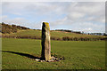
89m ENE 63° Midshiels Standing Stone* Standing Stone (Menhir) (NT53391774)
2.2km SSE 159° Cavers Cross* Ancient Cross (NT54071564)
4.9km SW 222° Hawick Mote* Misc. Earthwork (NT4994314073)
5.2km ESE 114° Rubers Law* Hillfort (NT58031557)
6.2km E 87° Bedrule Sculptured Stone (NT59501793)
6.2km E 85° Fast Castle (Bedrule)* Misc. Earthwork (NT59531822)
6.6km SSE 148° Hawthornside Farm (Bonchester Bridge)* Holy Well or Sacred Spring (NT5678612089)
6.6km E 87° Bedrule Parish Church* Sculptured Stone (NT5992217925)
9.6km SSW 212° Lord's Tree (Hawick)* Cairn (NT48090957)
10.0km S 178° Stonedge Stone Circle (NT536077)
10.1km SSW 211° Ca Knowe (Hawick)* Cairn (NT4793409075)
10.2km WSW 249° Borthwick Mains Class I Pictish Symbol Stone (NT4372814111)
10.4km E 95° Gilliestongues Promontory Fort / Cliff Castle (NT63721659)
10.6km WSW 240° Whitcastle Hill* Hillfort (NT44101245)
10.8km WSW 238° Whitcastle Sike* Ancient Village or Settlement (NT44011207)
11.4km NE 50° Ancrum Old Church* Sculptured Stone (NT6215024885)
11.6km NE 51° Castle Hill (Ancrum)* Hillfort (NT6239424909)
11.6km NNW 332° Caulks Well (Selkirk)* Holy Well or Sacred Spring (NT4789127983)
11.8km NNW 329° Mungo's Well (Selkirk)* Holy Well or Sacred Spring (NT47342795)
12.0km ENE 77° Jedburgh Ancient Christian Stones* Ancient Cross (NT65052038)
12.1km ENE 76° Jedburgh Rock Art Rock Art (NT651204)
12.4km ENE 59° Harestanes (Ancrum) Stone Circle (NT640240)
12.5km ENE 59° Harestanes (Ancrum) Stone Circle (NT641240)
13.1km SSW 208° Burgh Hill Stone Circle* Stone Circle (NT47010624)
13.1km NE 50° Harrietsfield Standing Stone (Menhir) (NT63442599)
View more nearby sites and additional images


 We would like to know more about this location. Please feel free to add a brief description and any relevant information in your own language.
 Wir möchten mehr über diese Stätte erfahren. Bitte zögern Sie nicht, eine kurze Beschreibung und relevante Informationen in Deutsch hinzuzufügen.
 Nous aimerions en savoir encore un peu sur les lieux. S'il vous plaît n'hesitez pas à ajouter une courte description et tous les renseignements pertinents dans votre propre langue.
 Quisieramos informarnos un poco más de las lugares. No dude en añadir una breve descripción y otros datos relevantes en su propio idioma.