<< Our Photo Pages >> Lord's Tree (Hawick) - Cairn in Scotland in Scottish Borders
Submitted by Anne T on Sunday, 04 June 2017 Page Views: 2151
Neolithic and Bronze AgeSite Name: Lord's Tree (Hawick)Country: Scotland County: Scottish Borders Type: Cairn
Nearest Town: Hawick
Map Ref: NT48090957
Latitude: 55.377350N Longitude: 2.820734W
Condition:
| 5 | Perfect |
| 4 | Almost Perfect |
| 3 | Reasonable but with some damage |
| 2 | Ruined but still recognisable as an ancient site |
| 1 | Pretty much destroyed, possibly visible as crop marks |
| 0 | No data. |
| -1 | Completely destroyed |
| 5 | Superb |
| 4 | Good |
| 3 | Ordinary |
| 2 | Not Good |
| 1 | Awful |
| 0 | No data. |
| 5 | Can be driven to, probably with disabled access |
| 4 | Short walk on a footpath |
| 3 | Requiring a bit more of a walk |
| 2 | A long walk |
| 1 | In the middle of nowhere, a nightmare to find |
| 0 | No data. |
| 5 | co-ordinates taken by GPS or official recorded co-ordinates |
| 4 | co-ordinates scaled from a detailed map |
| 3 | co-ordinates scaled from a bad map |
| 2 | co-ordinates of the nearest village |
| 1 | co-ordinates of the nearest town |
| 0 | no data |
Internal Links:
External Links:
I have visited· I would like to visit
Anne T visited on 3rd Jun 2017 - their rating: Cond: 3 Amb: 4 Access: 4 Lord's Tree Cairn, Hawick: We arrived in Hawick, intending to buy a map, but the majority of the shops (apart from the bookmakers, charity shops and 1 café, were closed (looking at the opening times, they largely shut at 2pm on a Saturday. The town seemed deserted apart from a few tourists. We later found out that most local people had gathered near the community centre for the Riding of the Marches.
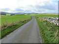
Relying upon the Trigpointing UK maps (good job there was a phone signal!), we navigated our way through the town (stopping off to look at The Mote on the way), past the golf course and out into the glorious open countryside with the hills beyond.
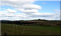
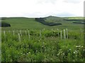
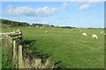
This cairn appears as a slight bump at the top of a small rise of a hill; it's unmistakably a large, low cairn, and the lush green grass and wild flowers invited a walk through the meadow towards it.
Completely circular, there is a low bank surrounding the cairn. Shame the old Lord's Tree wasn't there. Lovely view down to Ca Knowe Cairn further south.
 (PID:166427)")
This is an impressive cairn, recorded as Canmore ID 54109. They describe it as "a much denuded cairn about 33 ft in diameter .... enclosed by an old sod fence. It is said that a tree formerly grew here, though there is no trace of it now".
Border Archaeology adds to the description, saying Lord's Tree Cairn is on the "western side of the road shortly before coming to the Caa Knowe (cairn/monument). Its position is indicated by a raised area in the field. This is probably an ancient burial cairn (about 33 ft in diameter) with an enclosure around it. It may be related to the Caa Knowe cairn, which is nearby. The date that the tree grew in the centre is not known, but it was already an old tradition by the mid-19th century."
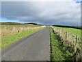
To reach the cairn, leave Hawick on the Rosebank Road, driving south past the roundabout at the southern edge of town where Rosebank Road meets Paterson Gardens and Haggis Ha'Brae roads. Continue past the Golf Clubhouse, travel for some 4.5 kms. The cairn is just over 900 metres from Pilsmuir Rig, on the left hand side of the road. A gate at the corner of the field nearest to Pilsmuir Rig gives access into the field, which at the time of our visit was lush grass and wild flower meadow.
You may be viewing yesterday's version of this page. To see the most up to date information please register for a free account.
 (PID:166426)")
 (PID:166425)")
 (PID:166424)")
Do not use the above information on other web sites or publications without permission of the contributor.
Nearby Images from Geograph Britain and Ireland:
©2012(licence)
©2007(licence)
©2022(licence)
©2006(licence)
©2022(licence)
The above images may not be of the site on this page, they are loaded from Geograph.
Please Submit an Image of this site or go out and take one for us!
Click here to see more info for this site
Nearby sites
Key: Red: member's photo, Blue: 3rd party photo, Yellow: other image, Green: no photo - please go there and take one, Grey: site destroyed
Download sites to:
KML (Google Earth)
GPX (GPS waypoints)
CSV (Garmin/Navman)
CSV (Excel)
To unlock full downloads you need to sign up as a Contributory Member. Otherwise downloads are limited to 50 sites.
Turn off the page maps and other distractions
Nearby sites listing. In the following links * = Image available
518m SSW 197° Ca Knowe (Hawick)* Cairn (NT4793409075)
3.5km SSW 197° Burgh Hill Stone Circle* Stone Circle (NT47010624)
3.6km SSW 200° Burgh Hill Hillfort* Hillfort (NT46810616)
3.7km SSW 192° The Dod* Ancient Village or Settlement (NT47260600)
4.8km WNW 301° Whitcastle Sike* Ancient Village or Settlement (NT44011207)
4.9km NNE 22° Hawick Mote* Misc. Earthwork (NT4994314073)
4.9km NW 305° Whitcastle Hill* Hillfort (NT44101245)
5.8km ESE 108° Stonedge Stone Circle (NT536077)
6.3km NW 316° Borthwick Mains Class I Pictish Symbol Stone (NT4372814111)
8.5km NE 44° Cavers Cross* Ancient Cross (NT54071564)
9.0km ENE 73° Hawthornside Farm (Bonchester Bridge)* Holy Well or Sacred Spring (NT5678612089)
9.6km NNE 32° Midshiels Cairn* Cairn (NT53311770)
9.7km NNE 32° Midshiels Standing Stone* Standing Stone (Menhir) (NT53391774)
11.6km ENE 58° Rubers Law* Hillfort (NT58031557)
12.8km SSE 163° Ninestanes Rig* Stone Circle (NY51809731)
13.6km S 169° The Buck Stone (Buckstone Rig)* Standing Stone (Menhir) (NY50509622)
14.0km SW 227° Wrangway Burn* Rock Art (NT377001)
14.1km NE 53° Bedrule Sculptured Stone (NT59501793)
14.3km NE 52° Fast Castle (Bedrule)* Misc. Earthwork (NT59531822)
14.5km NE 54° Bedrule Parish Church* Sculptured Stone (NT5992217925)
14.7km WNW 288° Black Rig Standing Stone (Menhir) (NT34151437)
15.1km SE 137° Caddrounburn Calvert* Ancient Village or Settlement (NY58199836)
15.4km E 90° Southdean Law* Hillfort (NT63500938)
17.1km ENE 65° Gilliestongues Promontory Fort / Cliff Castle (NT63721659)
17.8km NNW 345° Tamlane's Well (Carterhaugh)* Holy Well or Sacred Spring (NT43742681)
View more nearby sites and additional images


 We would like to know more about this location. Please feel free to add a brief description and any relevant information in your own language.
 Wir möchten mehr über diese Stätte erfahren. Bitte zögern Sie nicht, eine kurze Beschreibung und relevante Informationen in Deutsch hinzuzufügen.
 Nous aimerions en savoir encore un peu sur les lieux. S'il vous plaît n'hesitez pas à ajouter une courte description et tous les renseignements pertinents dans votre propre langue.
 Quisieramos informarnos un poco más de las lugares. No dude en añadir una breve descripción y otros datos relevantes en su propio idioma.