<< Our Photo Pages >> Fairy Toot - Long Barrow in England in Somerset
Submitted by TheCaptain on Saturday, 04 September 2004 Page Views: 22851
Neolithic and Bronze AgeSite Name: Fairy Toot Alternative Name: Nempnett ThrubwellCountry: England County: Somerset Type: Long Barrow
Nearest Town: Bristol Nearest Village: Butcombe
Map Ref: ST52056178 Landranger Map Number: 172
Latitude: 51.353060N Longitude: 2.689954W
Condition:
| 5 | Perfect |
| 4 | Almost Perfect |
| 3 | Reasonable but with some damage |
| 2 | Ruined but still recognisable as an ancient site |
| 1 | Pretty much destroyed, possibly visible as crop marks |
| 0 | No data. |
| -1 | Completely destroyed |
| 5 | Superb |
| 4 | Good |
| 3 | Ordinary |
| 2 | Not Good |
| 1 | Awful |
| 0 | No data. |
| 5 | Can be driven to, probably with disabled access |
| 4 | Short walk on a footpath |
| 3 | Requiring a bit more of a walk |
| 2 | A long walk |
| 1 | In the middle of nowhere, a nightmare to find |
| 0 | No data. |
| 5 | co-ordinates taken by GPS or official recorded co-ordinates |
| 4 | co-ordinates scaled from a detailed map |
| 3 | co-ordinates scaled from a bad map |
| 2 | co-ordinates of the nearest village |
| 1 | co-ordinates of the nearest town |
| 0 | no data |
Internal Links:
External Links:
I have visited· I would like to visit
paulinelen would like to visit
Bladup TheCaptain have visited here
")
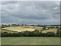
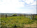
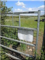
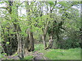
What remains is now largely flattened rubble with trees and scrub growing on it. Within the centre of the barrow are remains of a sheep shed or suchlike, almost certainly built using stones from the barrow.
However, at the north end is a small insight into the probable glory of its original form, where a couple of small mounds remain under the roots of trees. These remains are over 2m in height, and are clearly seen to have the outer face constructed of drystone walling. In fact, it is possible to make out the remains of what was possibly an opening of some sort and what was possibly a chamber entrance, but it is always possible that these are more modern alterations.
It is recorded that an excavation in 1788 produced evidence of a gallery with several chambers, and remains of skeletons were found.
Legend has it that fairies and goblins can be seen here.
See here for more.
You may be viewing yesterday's version of this page. To see the most up to date information please register for a free account.
")
")
")
Do not use the above information on other web sites or publications without permission of the contributor.
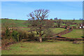
Nearby Images from Geograph Britain and Ireland:
©2011(licence)
©2021(licence)
©2021(licence)
©2021(licence)
©2023(licence)
The above images may not be of the site on this page, they are loaded from Geograph.
Please Submit an Image of this site or go out and take one for us!
Click here to see more info for this site
Nearby sites
Key: Red: member's photo, Blue: 3rd party photo, Yellow: other image, Green: no photo - please go there and take one, Grey: site destroyed
Download sites to:
KML (Google Earth)
GPX (GPS waypoints)
CSV (Garmin/Navman)
CSV (Excel)
To unlock full downloads you need to sign up as a Contributory Member. Otherwise downloads are limited to 50 sites.
Turn off the page maps and other distractions
Nearby sites listing. In the following links * = Image available
1.0km NNW 336° Butcombe Barrow* Round Barrow(s) (ST51646273)
2.8km NW 311° Red Hill Longbarrow Chambered Tomb (ST49956361)
3.0km NE 45° Leigh Down* Stone Circle (ST542639)
3.0km N 358° Felton Bowl Barrows T28 & T29* Round Barrow(s) (ST51966480)
3.0km N 356° Felton Common Suck Stone* Natural Stone / Erratic / Other Natural Feature (ST5187164800)
3.1km N 1° Felton Hill Bowl Barrow T30A* Round Barrow(s) (ST52126490)
3.2km N 352° Felton Hill Long Barrow T26* Chambered Tomb (ST51626491)
3.3km NW 322° The Waterstone* Burial Chamber or Dolmen (ST5006464403)
3.7km N 5° Felton Village Bowl Barrow* Round Barrow(s) (ST52386550)
3.8km ENE 77° Pagans Hill* Ancient Temple (ST55766261)
3.9km E 92° Chew Stoke* Stone Circle (ST560616)
4.8km SSE 159° Barrow Well (Compton Martin) Holy Well or Sacred Spring (ST537573)
5.2km SW 234° Burrington Camp* Hillfort (ST47825878)
5.4km SW 234° Aveline's Hole* Cave or Rock Shelter (ST47615867)
5.7km SSW 202° Charterhouse Earthwork* Misc. Earthwork (ST49885651)
5.8km SW 218° Beacon Batch* Barrow Cemetery (ST48465726)
5.8km S 171° Fernhill Farm* Modern Stone Circle etc (ST52865606)
5.8km ENE 75° Chew Magna Church Cross Ancient Cross (ST5767363199)
6.1km SSW 191° Nordrach Tumulus* Round Barrow(s) (ST5078755765)
6.3km SSW 195° Charterhouse settlement* Misc. Earthwork (ST504557)
6.5km S 178° Whites Town Farm Tumulus* Round Barrow(s) (ST5223355265)
6.6km NW 322° Chelvey Batch Settlement Ancient Village or Settlement (ST480670)
6.7km SW 225° Black Down barrows (Mendip)* Barrow Cemetery (ST473571)
6.8km NW 321° Tap's Combe Camp* Promontory Fort / Cliff Castle (ST47796708)
6.8km NNW 337° Backwell Hillfort Hillfort (ST49406805)
View more nearby sites and additional images


 We would like to know more about this location. Please feel free to add a brief description and any relevant information in your own language.
 Wir möchten mehr über diese Stätte erfahren. Bitte zögern Sie nicht, eine kurze Beschreibung und relevante Informationen in Deutsch hinzuzufügen.
 Nous aimerions en savoir encore un peu sur les lieux. S'il vous plaît n'hesitez pas à ajouter une courte description et tous les renseignements pertinents dans votre propre langue.
 Quisieramos informarnos un poco más de las lugares. No dude en añadir una breve descripción y otros datos relevantes en su propio idioma.