<< Our Photo Pages >> Hawell Burnt Mound - Round Barrow(s) in Scotland in Orkney
Submitted by howar on Sunday, 28 March 2004 Page Views: 5201
Neolithic and Bronze AgeSite Name: Hawell Burnt MoundCountry: Scotland County: Orkney Type: Round Barrow(s)
Nearest Town: Kirkwall Nearest Village: Toab
Map Ref: HY512065 Landranger Map Number: 6
Latitude: 58.942936N Longitude: 2.84972W
Condition:
| 5 | Perfect |
| 4 | Almost Perfect |
| 3 | Reasonable but with some damage |
| 2 | Ruined but still recognisable as an ancient site |
| 1 | Pretty much destroyed, possibly visible as crop marks |
| 0 | No data. |
| -1 | Completely destroyed |
| 5 | Superb |
| 4 | Good |
| 3 | Ordinary |
| 2 | Not Good |
| 1 | Awful |
| 0 | No data. |
| 5 | Can be driven to, probably with disabled access |
| 4 | Short walk on a footpath |
| 3 | Requiring a bit more of a walk |
| 2 | A long walk |
| 1 | In the middle of nowhere, a nightmare to find |
| 0 | No data. |
| 5 | co-ordinates taken by GPS or official recorded co-ordinates |
| 4 | co-ordinates scaled from a detailed map |
| 3 | co-ordinates scaled from a bad map |
| 2 | co-ordinates of the nearest village |
| 1 | co-ordinates of the nearest town |
| 0 | no data |
Internal Links:
External Links:
")
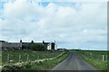
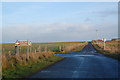
This site lies close to an exceptionally zigzaggy burn (another mound of similar nature now gone). Down the road fom Mine Howe looking to the right I could see a long green mound and at one end a standing stone. Coming round the junction nearer to Hawell I now saw another stone at right-angles to the first and apparently abutting i . On the other side of the road by the corner of Hawell at the roadside were two stones echoing the sight, the one parallel to the road having piercings top and bottom on one side. RCAHMS NMRS record HY50NW 10 describes this as several stone compatments with a slab-formed rectangular tank just off.
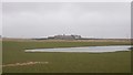
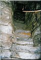
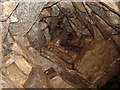
Well worth a visit if you are into decayed structures , 6 out of 10 . Entered the field by climbing over a wooden gate that is difficult owing to the close construction. First sight is a long mound with a standing stone on the left and a circular depression in the centre. Closer to the standing stone is the end of a close packed straight wall that still is exposed for several yards. From afar you can make out a few small stones about the depression, so it comes as a pleasant surprise as one climbs ever so slightly to look down and see this is filled by large slabs even if no clearly discernable structure . The back of the mound survives a bit higher, so it is a disappointment when one goes behind that this appears so nondescript. Here are the two modern structures that are presumably where the second mound used to be.
You may be viewing yesterday's version of this page. To see the most up to date information please register for a free account.
")
")
")
Do not use the above information on other web sites or publications without permission of the contributor.
Nearby Images from Geograph Britain and Ireland:
©2021(licence)
©2018(licence)
©2008(licence)
©2005(licence)
©2006(licence)
The above images may not be of the site on this page, they are loaded from Geograph.
Please Submit an Image of this site or go out and take one for us!
Click here to see more info for this site
Nearby sites
Key: Red: member's photo, Blue: 3rd party photo, Yellow: other image, Green: no photo - please go there and take one, Grey: site destroyed
Download sites to:
KML (Google Earth)
GPX (GPS waypoints)
CSV (Garmin/Navman)
CSV (Excel)
To unlock full downloads you need to sign up as a Contributory Member. Otherwise downloads are limited to 50 sites.
Turn off the page maps and other distractions
Nearby sites listing. In the following links * = Image available
360m SSW 213° Stem Howe* Round Barrow(s) (HY510062)
399m S 179° Longhowe Cairn (HY512061)
495m SSW 195° Mine Howe* Chambered Cairn (HY5106406023)
499m NW 306° Nearhouse* Ancient Village or Settlement (HY508068)
537m ENE 67° Muckle Crofty* Stone Row / Alignment (HY517067)
582m SSW 210° Long Howe* Long Barrow (HY509060)
723m SW 215° Round Howe* Broch or Nuraghe (HY50780591)
779m SW 219° Burn of Langskaill* Ancient Village or Settlement (HY507059)
941m ESE 121° Breck Farm* Standing Stones (HY520060)
1.0km WSW 240° Brymer* Round Barrow(s) (HY503060)
1.1km NE 40° Loch of Messigate* Standing Stones (HY519073)
1.5km N 3° Mill Sand* Standing Stones (HY513080)
2.0km N 356° Whitecleat* Holy Well or Sacred Spring (HY511085)
2.1km W 280° Craw Howe* Cairn (HY491069)
2.5km N 4° The Howie of The Manse* Broch or Nuraghe (HY514090)
2.7km NNE 21° Grieves Cottage* Standing Stone (Menhir) (HY522090)
2.9km SE 146° Campston (Toab)* Broch or Nuraghe (HY528041)
2.9km W 279° Staneloof* Cairn (HY48330698)
3.0km NNE 19° Loch of Tankerness* Ancient Village or Settlement (HY522093)
3.2km SE 128° St. Peter's Bay Mound* Broch or Nuraghe (HY537045)
3.3km E 92° Hurnip's Point* Chambered Cairn (HY54480634)
3.3km NE 37° Taing of Beeman* Ancient Village or Settlement (HY53210914)
3.3km SE 133° St. Peter's Kirk* Ancient Village or Settlement (HY536042)
3.4km SE 132° Campston Cairn* Cairn (HY537042)
3.5km W 268° Heathery Howes* Round Barrow(s) (HY477064)
View more nearby sites and additional images


 We would like to know more about this location. Please feel free to add a brief description and any relevant information in your own language.
 Wir möchten mehr über diese Stätte erfahren. Bitte zögern Sie nicht, eine kurze Beschreibung und relevante Informationen in Deutsch hinzuzufügen.
 Nous aimerions en savoir encore un peu sur les lieux. S'il vous plaît n'hesitez pas à ajouter une courte description et tous les renseignements pertinents dans votre propre langue.
 Quisieramos informarnos un poco más de las lugares. No dude en añadir una breve descripción y otros datos relevantes en su propio idioma.