


<< Our Photo Pages >> The Three brothers - Natural Stone / Erratic / Other Natural Feature in England in Lancashire
Submitted by Postman on Sunday, 27 September 2015 Page Views: 3286
Natural PlacesSite Name: The Three brothersCountry: England County: Lancashire Type: Natural Stone / Erratic / Other Natural Feature
Nearest Town: Carnforth Nearest Village: Warton
Map Ref: SD495735
Latitude: 54.154819N Longitude: 2.774762W
Condition:
| 5 | Perfect |
| 4 | Almost Perfect |
| 3 | Reasonable but with some damage |
| 2 | Ruined but still recognisable as an ancient site |
| 1 | Pretty much destroyed, possibly visible as crop marks |
| 0 | No data. |
| -1 | Completely destroyed |
| 5 | Superb |
| 4 | Good |
| 3 | Ordinary |
| 2 | Not Good |
| 1 | Awful |
| 0 | No data. |
| 5 | Can be driven to, probably with disabled access |
| 4 | Short walk on a footpath |
| 3 | Requiring a bit more of a walk |
| 2 | A long walk |
| 1 | In the middle of nowhere, a nightmare to find |
| 0 | No data. |
| 5 | co-ordinates taken by GPS or official recorded co-ordinates |
| 4 | co-ordinates scaled from a detailed map |
| 3 | co-ordinates scaled from a bad map |
| 2 | co-ordinates of the nearest village |
| 1 | co-ordinates of the nearest town |
| 0 | no data |
Internal Links:
External Links:
")
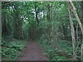
From the A6 head straight through the village of Warton, then look for a small picnic site on your left next to a footpath which is next to a house.
Go up the steep rocky path. Turn right over a stile in a wall next to a gate, there is a small map pointing out the three brothers, it wont help much, but it is reassuring to know your in the right place.
Take the second left clearing off the path, look for white cliffs, the brothers are above here.
Hope that helps, perhaps not.
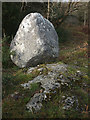
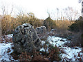
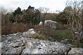
The three brothers are three large boulders in an almost straight line on a bit of limestone outcropping, some think they have been moved into position by our ancient brethren.
They are currently, more overgrown than in previous years, especially since my first visit ten years ago.
You may be viewing yesterday's version of this page. To see the most up to date information please register for a free account.
")
")
")
")
Do not use the above information on other web sites or publications without permission of the contributor.
Nearby Images from Geograph Britain and Ireland:
©2005(licence)
©2016(licence)
©2010(licence)
©2008(licence)
©2009(licence)
The above images may not be of the site on this page, they are loaded from Geograph.
Please Submit an Image of this site or go out and take one for us!
Click here to see more info for this site
Nearby sites
Key: Red: member's photo, Blue: 3rd party photo, Yellow: other image, Green: no photo - please go there and take one, Grey: site destroyed
Download sites to:
KML (Google Earth)
GPX (GPS waypoints)
CSV (Garmin/Navman)
CSV (Excel)
To unlock full downloads you need to sign up as a Contributory Member. Otherwise downloads are limited to 50 sites.
Turn off the page maps and other distractions
Nearby sites listing. In the following links * = Image available
565m SE 134° Warton Crag giant wall Misc. Earthwork (SD499731)
854m SSW 200° Warton Crag* Hillfort (SD492727)
1.0km NE 39° Summerhouse Hill Cairn* Cairn (SD50147428)
1.0km NNE 31° Summerhouse Hill* Modern Stone Circle etc (SD50037437)
1.3km WSW 247° Dog Holes* Cave or Rock Shelter (SD48337303)
1.5km WSW 243° Badger Hole (Lancashire)* Cave or Rock Shelter (SD48187285)
1.7km WSW 252° Ings Point Natural Stone / Erratic / Other Natural Feature (SD479730)
2.1km SW 218° Cote Stones Cairn (SD482719)
2.2km ENE 59° Yealand ancient stone walls or rows 1 Misc. Earthwork (SD514746)
2.5km NE 44° Yealand ancient stone walls or rows 2 Misc. Earthwork (SD513753)
2.9km S 189° Hunting Hill* Round Barrow(s) (SD49037065)
2.9km ESE 102° Manor Farm* Round Barrow(s) (SD52387285)
3.5km W 278° Woodwell* Holy Well or Sacred Spring (SD4674)
3.8km NNW 334° Haweswater Cairns and Propped Stone Cairn (SD479769)
3.8km NNW 327° Bowk Stone Natural Stone / Erratic / Other Natural Feature (SD475767)
3.9km NNW 334° Haweswater Stones* Misc. Earthwork (SD478770)
4.9km NE 45° St James's Church (Burton-in-Kendal) Ancient Cross (SD5305076921)
5.3km NNW 335° Hazelslack Stone* Standing Stone (Menhir) (SD473783)
5.5km N 352° The Fairy Steps* Natural Stone / Erratic / Other Natural Feature (SD488790)
5.7km N 2° The Rent Stone* Natural Stone / Erratic / Other Natural Feature (SD498792)
5.8km SSW 191° St Michael's Well (Lancashire) Holy Well or Sacred Spring (SD4828567831)
5.9km S 184° Bolton-le-Sands Barrow* Ring Cairn (SD4901467624)
6.0km S 191° Bolton Le Sands Early Christian Sculptured Stone (SD48336765)
6.6km N 359° Bela Stone Row* Stone Row / Alignment (SD495801)
6.6km NW 312° Grubbins Wood Stone Natural Stone / Erratic / Other Natural Feature (SD446780)
View more nearby sites and additional images


 We would like to know more about this location. Please feel free to add a brief description and any relevant information in your own language.
 Wir möchten mehr über diese Stätte erfahren. Bitte zögern Sie nicht, eine kurze Beschreibung und relevante Informationen in Deutsch hinzuzufügen.
 Nous aimerions en savoir encore un peu sur les lieux. S'il vous plaît n'hesitez pas à ajouter une courte description et tous les renseignements pertinents dans votre propre langue.
 Quisieramos informarnos un poco más de las lugares. No dude en añadir una breve descripción y otros datos relevantes en su propio idioma.