


<< Our Photo Pages >> Duni Geo - Long Barrow in Scotland in Orkney
Submitted by howar on Sunday, 31 August 2008 Page Views: 11542
Neolithic and Bronze AgeSite Name: Duni GeoCountry: Scotland County: Orkney Type: Long Barrow
Nearest Town: St.Margaret's Hope
Map Ref: ND46958425
Latitude: 58.742638N Longitude: 2.918257W
Condition:
| 5 | Perfect |
| 4 | Almost Perfect |
| 3 | Reasonable but with some damage |
| 2 | Ruined but still recognisable as an ancient site |
| 1 | Pretty much destroyed, possibly visible as crop marks |
| 0 | No data. |
| -1 | Completely destroyed |
| 5 | Superb |
| 4 | Good |
| 3 | Ordinary |
| 2 | Not Good |
| 1 | Awful |
| 0 | No data. |
| 5 | Can be driven to, probably with disabled access |
| 4 | Short walk on a footpath |
| 3 | Requiring a bit more of a walk |
| 2 | A long walk |
| 1 | In the middle of nowhere, a nightmare to find |
| 0 | No data. |
| 5 | co-ordinates taken by GPS or official recorded co-ordinates |
| 4 | co-ordinates scaled from a detailed map |
| 3 | co-ordinates scaled from a bad map |
| 2 | co-ordinates of the nearest village |
| 1 | co-ordinates of the nearest town |
| 0 | no data |
Internal Links:
External Links:
")
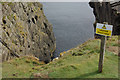
The 1958 newspaper report on the Tomb of the Eagles reports a little disturbed long grass-covered mound (smaller than Isbister) between the tomb and the burnt mound settlement, with a few protruding stones. This can be found where North Taing appears on the O.S. as you are in close sight of the Tomb of The Eagles, inside a field.
It is a low bolster shape of earth with a few stones of varying size, and ends just before the modern fence. It is most striking that a only a few metres to its south is the angled top of a very regular-shaped stone, projecting a couple of feet or so and about six inches thick.
My rough measurements give NGRs for the stone at ND46938423 and the eastern end of the mound at ND46958425.
You may be viewing yesterday's version of this page. To see the most up to date information please register for a free account.
")
")
Do not use the above information on other web sites or publications without permission of the contributor.
Nearby Images from Geograph Britain and Ireland:
©2009(licence)
©2013(licence)

©2025(licence)
©2018(licence)
©2007(licence)
The above images may not be of the site on this page, they are loaded from Geograph.
Please Submit an Image of this site or go out and take one for us!
Click here to see more info for this site
Nearby sites
Key: Red: member's photo, Blue: 3rd party photo, Yellow: other image, Green: no photo - please go there and take one, Grey: site destroyed
Download sites to:
KML (Google Earth)
GPX (GPS waypoints)
CSV (Garmin/Navman)
CSV (Excel)
To unlock full downloads you need to sign up as a Contributory Member. Otherwise downloads are limited to 50 sites.
Turn off the page maps and other distractions
Nearby sites listing. In the following links * = Image available
256m NNE 20° Isbister: Tomb Of The Eagles* Chambered Cairn (ND47048449)
467m WSW 258° Liddel 2 Burnt Mound Ancient Village or Settlement (ND46498416)
508m WSW 253° Isbister: Bronze Age House* Ancient Village or Settlement (ND46468411)
871m WSW 239° Tomb of the Eagles Museum Museum (ND4619783807)
1.4km SW 232° Banks Chambered Tomb* Chambered Cairn (ND45808339)
2.9km W 270° Ladykirk Stone* Rock Art (ND44008428)
3.2km NNW 338° The Cairns Windwick Bay* Broch or Nuraghe (ND4578987256)
4.8km N 354° Stews* Standing Stone (Menhir) (ND465890)
5.8km NW 322° Weems Castle Broch or Nuraghe (ND434889)
6.3km NNW 327° Clouduhall Stone* Standing Stone (Menhir) (ND43538957)
6.3km NNW 326° Clouduhall Cairn* Round Cairn (ND43498958)
6.6km N 360° Kirkhouse* Round Cairn (ND470909)
6.9km N 3° Kirk Ness* Round Cairn (ND47389117)
7.0km N 3° Kirk Ness Dyke* Ancient Village or Settlement (ND474912)
7.1km N 359° Eastside* Standing Stone (Menhir) (ND469914)
8.1km NW 318° Harra Brough* Broch or Nuraghe (ND41579038)
8.9km NNW 337° Oyce of Quindry* Standing Stone (Menhir) (ND436925)
9.9km NNW 338° The Wart* Chambered Cairn (ND433935)
10.7km NNW 335° Howe of Hoxa* Broch or Nuraghe (ND425940)
10.7km NNW 334° Little Howe of Hoxa* Ancient Village or Settlement (ND4243694026)
10.8km NNW 334° Little Howe of Hoxa* Ancient Village or Settlement (ND42439403)
11.1km N 7° Kyelittle* Broch or Nuraghe (ND485953)
12.4km N 10° St Lawrence's Church* Broch or Nuraghe (ND4917896425)
13.5km WNW 290° Cantick Head Bowl Barrow Round Barrow(s) (ND34318915)
13.7km WNW 292° Outer Green Hill Broch Chambered Cairn (ND34258958)
View more nearby sites and additional images


 We would like to know more about this location. Please feel free to add a brief description and any relevant information in your own language.
 Wir möchten mehr über diese Stätte erfahren. Bitte zögern Sie nicht, eine kurze Beschreibung und relevante Informationen in Deutsch hinzuzufügen.
 Nous aimerions en savoir encore un peu sur les lieux. S'il vous plaît n'hesitez pas à ajouter une courte description et tous les renseignements pertinents dans votre propre langue.
 Quisieramos informarnos un poco más de las lugares. No dude en añadir una breve descripción y otros datos relevantes en su propio idioma.