<< Our Photo Pages >> Bush Bank - Standing Stone (Menhir) in England in Herefordshire
Submitted by Bladup on Sunday, 28 July 2013 Page Views: 4979
Neolithic and Bronze AgeSite Name: Bush BankCountry: England
NOTE: This site is 2.7 km away from the location you searched for.
County: Herefordshire Type: Standing Stone (Menhir)
Map Ref: SO4496251449
Latitude: 52.158558N Longitude: 2.805957W
Condition:
| 5 | Perfect |
| 4 | Almost Perfect |
| 3 | Reasonable but with some damage |
| 2 | Ruined but still recognisable as an ancient site |
| 1 | Pretty much destroyed, possibly visible as crop marks |
| 0 | No data. |
| -1 | Completely destroyed |
| 5 | Superb |
| 4 | Good |
| 3 | Ordinary |
| 2 | Not Good |
| 1 | Awful |
| 0 | No data. |
| 5 | Can be driven to, probably with disabled access |
| 4 | Short walk on a footpath |
| 3 | Requiring a bit more of a walk |
| 2 | A long walk |
| 1 | In the middle of nowhere, a nightmare to find |
| 0 | No data. |
| 5 | co-ordinates taken by GPS or official recorded co-ordinates |
| 4 | co-ordinates scaled from a detailed map |
| 3 | co-ordinates scaled from a bad map |
| 2 | co-ordinates of the nearest village |
| 1 | co-ordinates of the nearest town |
| 0 | no data |
Internal Links:
External Links:
")
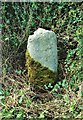
A reputed standing stone right next to the road, it's marked "stone" on OS maps.
You may be viewing yesterday's version of this page. To see the most up to date information please register for a free account.
")
Do not use the above information on other web sites or publications without permission of the contributor.
davidmorgan has found this location on Google Street View:
Nearby Images from Geograph Britain and Ireland:
©2017(licence)
©2011(licence)
©2006(licence)
©2009(licence)
©2010(licence)
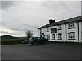
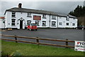
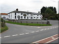
The above images may not be of the site on this page, they are loaded from Geograph.
Please Submit an Image of this site or go out and take one for us!
Click here to see more info for this site
Nearby sites
Key: Red: member's photo, Blue: 3rd party photo, Yellow: other image, Green: no photo - please go there and take one, Grey: site destroyed
Download sites to:
KML (Google Earth)
GPX (GPS waypoints)
CSV (Garmin/Navman)
CSV (Excel)
To unlock full downloads you need to sign up as a Contributory Member. Otherwise downloads are limited to 50 sites.
Turn off the page maps and other distractions
Nearby sites listing. In the following links * = Image available
4.7km NE 46° Ivington Camp* Hillfort (SO484547)
6.9km S 178° Credenhill Camp* Hillfort (SO451445)
7.0km E 86° Dinmore Hill Hillfort (SO520519)
7.6km SE 124° St Ethelbert's Well (Marden)* Holy Well or Sacred Spring (SO512471)
9.1km ESE 123° Sutton Walls* Hillfort (SO525464)
9.2km S 176° Holy Well (Garway)* Holy Well or Sacred Spring (SO45554224)
9.5km ENE 59° Blackwardine Crossroads* Modern Stone Circle etc (SO5318656161)
9.7km WNW 300° Tank Cottage Standing Stone (Menhir) (SO36615640)
9.8km S 187° Holy Well (Swainshill)* Holy Well or Sacred Spring (SO43724177)
9.8km N 358° St Michael's Church (Kingsland)* Ancient Cross (SO4468461269)
10.0km ENE 66° Risbury Camp* Hillfort (SO542554)
10.9km SE 132° The Wergin's Stone* Standing Stone (Menhir) (SO5297543981)
12.2km S 177° Eaton Camp* Promontory Fort / Cliff Castle (SO454393)
12.5km NNE 16° Luston Holy Well* Holy Well or Sacred Spring (SO4859563407)
12.7km SW 216° Holy Well (Blakemere)* Holy Well or Sacred Spring (SO37254128)
13.0km NE 47° Bach Camp* Hillfort (SO546602)
13.0km SSE 152° Hereford Museum and Art Gallery* Museum (SO5090039851)
13.1km SSE 153° The King's Ditch Natural Stone / Erratic / Other Natural Feature (SO50873974)
13.3km SSE 152° St Ethelbert's Well (Hereford)* Holy Well or Sacred Spring (SO5112239684)
13.4km WSW 238° Bredwardine Church* Carving (SO33484450)
13.5km SW 220° Blakemere Church Stone* Marker Stone (SO362411)
13.9km ENE 59° Uphampton Camp Hillfort (SO57005838)
13.9km N 349° St John the Baptist and St Alkmund (Aymestrey)* Ancient Cross (SO4256065130)
14.2km WSW 241° The Knapp (Bredwardine)* Ancient Village or Settlement (SO32454467)
14.4km WSW 239° Chapel field Hillfort (SO32404425)
View more nearby sites and additional images


 We would like to know more about this location. Please feel free to add a brief description and any relevant information in your own language.
 Wir möchten mehr über diese Stätte erfahren. Bitte zögern Sie nicht, eine kurze Beschreibung und relevante Informationen in Deutsch hinzuzufügen.
 Nous aimerions en savoir encore un peu sur les lieux. S'il vous plaît n'hesitez pas à ajouter une courte description et tous les renseignements pertinents dans votre propre langue.
 Quisieramos informarnos un poco más de las lugares. No dude en añadir una breve descripción y otros datos relevantes en su propio idioma.