<< Our Photo Pages >> Doghouse Hill - Ancient Village or Settlement in England in Dorset
Submitted by coldrum on Thursday, 28 May 2009 Page Views: 13287
Multi-periodSite Name: Doghouse HillCountry: England
NOTE: This site is 0.6 km away from the location you searched for.
County: Dorset Type: Ancient Village or Settlement
Nearest Town: Bridport Nearest Village: Chideock
Map Ref: SY430915
Latitude: 50.720316N Longitude: 2.808819W
Condition:
| 5 | Perfect |
| 4 | Almost Perfect |
| 3 | Reasonable but with some damage |
| 2 | Ruined but still recognisable as an ancient site |
| 1 | Pretty much destroyed, possibly visible as crop marks |
| 0 | No data. |
| -1 | Completely destroyed |
| 5 | Superb |
| 4 | Good |
| 3 | Ordinary |
| 2 | Not Good |
| 1 | Awful |
| 0 | No data. |
| 5 | Can be driven to, probably with disabled access |
| 4 | Short walk on a footpath |
| 3 | Requiring a bit more of a walk |
| 2 | A long walk |
| 1 | In the middle of nowhere, a nightmare to find |
| 0 | No data. |
| 5 | co-ordinates taken by GPS or official recorded co-ordinates |
| 4 | co-ordinates scaled from a detailed map |
| 3 | co-ordinates scaled from a bad map |
| 2 | co-ordinates of the nearest village |
| 1 | co-ordinates of the nearest town |
| 0 | no data |
Be the first person to rate this site - see the 'Contribute!' box in the right hand menu.
Internal Links:
External Links:
I have visited· I would like to visit
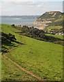
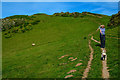
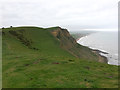
TheCaptain saw from a distance on 15th Oct 2020 Seen from a distance during a walk from Seatown up the coast path up and over the Golden Cap and around Stanton St Gabriel and back.
")
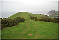
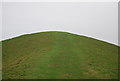
Experts now believe people lived on Doghouse Hill on the Golden Cap estate up to 10,000 years ago.
Finds included a stone hearth, fire pit and pot shards from Bronze Age periods (2,500 to 1,000BC) and others from the Mesolithic Age (10,000 to 4,000BC)
Martin Papworth, from the National Trust, said: "Although it's a stunning coastal site now, 6,000 to 8,000 years ago this area would have been over a mile inland.
To find ancient pottery decorated with fingernail impressions and touch them with one's own hand, that's real contact with the past
Martin Papworth, National Trust
"The Mesolithic people who lived on top of Doghouse hill would have pre-dated farming, so would have been hunter-gatherers using these flints to work hides, cut meat and scrape fat from animal skins.
"After millennia of erosion, it's at risk of disappearing into the sea itself."
Further tests will now be carried out to accurately date the finds, which include ancient pottery decorated with fingernail imprints.
Mr Papworth added: "To find ancient pottery decorated with fingernail impressions and touch them with one's own hand, that's real contact with the past."
The dog walker whose finds sparked the dig has collected scores of artefacts in the area for more than 40 years, with many of his pieces housed in the Dorset County Museum.
Source: BBC News
You may be viewing yesterday's version of this page. To see the most up to date information please register for a free account.
")
")
Do not use the above information on other web sites or publications without permission of the contributor.
Nearby Images from Geograph Britain and Ireland:
©2012(licence)
©2012(licence)
©2020(licence)
©2012(licence)
©2017(licence)
The above images may not be of the site on this page, they are loaded from Geograph.
Please Submit an Image of this site or go out and take one for us!
Click here to see more info for this site
Nearby sites
Key: Red: member's photo, Blue: 3rd party photo, Yellow: other image, Green: no photo - please go there and take one, Grey: site destroyed
Download sites to:
KML (Google Earth)
GPX (GPS waypoints)
CSV (Garmin/Navman)
CSV (Excel)
To unlock full downloads you need to sign up as a Contributory Member. Otherwise downloads are limited to 50 sites.
Turn off the page maps and other distractions
Nearby sites listing. In the following links * = Image available
2.5km WNW 283° Golden Cap Barrows* Barrow Cemetery (SY40569211)
3.8km NW 306° St Candida's Well* Holy Well or Sacred Spring (SY3995193753)
5.1km NW 319° St Candida & Holy Cross (Whitchurch Canonicorum)* Early Christian Sculptured Stone (SY3967895432)
6.9km ESE 112° Bind Barrow* Round Barrow(s) (SY494888)
7.7km E 85° Shipton Hill* Hillfort (SY507921)
8.3km NW 315° Coney's Castle* Hillfort (SY372975)
8.9km W 274° Leper's Well (Lyme Regis)* Holy Well or Sacred Spring (SY3411292224)
9.4km NNW 343° Bettiscombe Stone Natural Stone / Erratic / Other Natural Feature (ST4036800561)
9.5km NW 322° Lambert's Castle* Hillfort (SY372991)
9.7km N 3° Lewesdon Hillfort Hillfort (ST437012)
9.8km E 89° Chilcombe Hill Barrows* Round Barrow(s) (SY528916)
9.9km N 350° Pilsdon Pen* Hillfort (ST413013)
10.0km E 87° Chilcombe Hill* Hillfort (SY530920)
10.9km ESE 109° Puncknowle Bowl Barrows Round Barrow(s) (SY53308783)
11.3km N 1° St Dunstan's Well* Holy Well or Sacred Spring (ST433028)
11.5km ENE 73° Eggardon Hill* Hillfort (SY54129472)
12.1km ENE 74° Eggardon earthwork* Henge (SY54689460)
12.6km E 88° Litton Cheney* Timber Circle (SY5562591741)
12.7km E 79° Two Gates (Dorset)* Burial Chamber or Dolmen (SY5548593770)
12.7km ESE 112° Tulk's Hill Bowl Barrows Barrow Cemetery (SY54798668)
12.8km W 276° Shapwick Hill Bowl Barrows Barrow Cemetery (SY303930)
13.4km ESE 111° Abbotsbury Castle* Hillfort (SY555866)
13.7km E 81° West Compton Bowl Barrow Round Barrow(s) (SY56619347)
13.9km E 90° Martin's Down Round Barrows* Round Barrow(s) (SY569913)
14.0km ESE 103° Kingston Russell Long Barrow Long Barrow (SY5669088244)
View more nearby sites and additional images


 We would like to know more about this location. Please feel free to add a brief description and any relevant information in your own language.
 Wir möchten mehr über diese Stätte erfahren. Bitte zögern Sie nicht, eine kurze Beschreibung und relevante Informationen in Deutsch hinzuzufügen.
 Nous aimerions en savoir encore un peu sur les lieux. S'il vous plaît n'hesitez pas à ajouter une courte description et tous les renseignements pertinents dans votre propre langue.
 Quisieramos informarnos un poco más de las lugares. No dude en añadir una breve descripción y otros datos relevantes en su propio idioma.