


<< Our Photo Pages >> Belair Bowl Barrow - Round Barrow(s) in England in Shropshire
Submitted by TheWhiteRider on Sunday, 15 October 2006 Page Views: 5903
Neolithic and Bronze AgeSite Name: Belair Bowl BarrowCountry: England
NOTE: This site is 0.676 km away from the location you searched for.
County: Shropshire Type: Round Barrow(s)
Nearest Town: Craven Arms Nearest Village: Wistanstow
Map Ref: SO430840
Latitude: 52.450969N Longitude: 2.840157W
Condition:
| 5 | Perfect |
| 4 | Almost Perfect |
| 3 | Reasonable but with some damage |
| 2 | Ruined but still recognisable as an ancient site |
| 1 | Pretty much destroyed, possibly visible as crop marks |
| 0 | No data. |
| -1 | Completely destroyed |
| 5 | Superb |
| 4 | Good |
| 3 | Ordinary |
| 2 | Not Good |
| 1 | Awful |
| 0 | No data. |
| 5 | Can be driven to, probably with disabled access |
| 4 | Short walk on a footpath |
| 3 | Requiring a bit more of a walk |
| 2 | A long walk |
| 1 | In the middle of nowhere, a nightmare to find |
| 0 | No data. |
| 5 | co-ordinates taken by GPS or official recorded co-ordinates |
| 4 | co-ordinates scaled from a detailed map |
| 3 | co-ordinates scaled from a bad map |
| 2 | co-ordinates of the nearest village |
| 1 | co-ordinates of the nearest town |
| 0 | no data |
Internal Links:
External Links:
I have visited· I would like to visit
TheWhiteRider has visited here
")
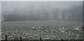
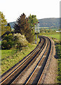
A possible bowl barrow on private land, partly destroyed by a railway embankment.
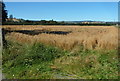
The site is extremely difficult to get a look at. Firstly ignore suggestions on the OS Explorer map that there is an accessible path crossing the railway lines and passing close by the barrow. We parked at the Onny Fields car park close to the ugly new railway bridge and after following some confusing public footpath signs across a couple of muddy fields were presented with recently constructed high fencing and no clear or safe access across the railway lines. Another permissive path between Cheney Longville also ends abruptly at a briar patch and impassable fences alongside the railway.
Undeterred we backtracked, crossed the railway bridge and decided to try the route marked as an accessible path from the other direction. This takes you past the frontages of several homes close to the A49 and suddenly ends at a heavily overgrown track. We hacked our way through this until it reached a dead end close to the railway lines. Glimpses of the possible barrow topped by an old Oak and the close by, but now dried up, pond (referred to by Chitty and others on the Archsearch entry) were only afforded by crawling through undergrowth to the edge of a fence.
The barrow itself appears as quite a slight mound topped by an oak tree. Doubt about its Bronze Age origin centers on its close proximity to a pond and suggestions that the mound is the result of digging the pond. If this is true it must have been dug hundreds of years ago because of the great age of the oak tree.
An intriguing, but quite frustrating visit. The state of the footpaths was poor in this area and no consideration that a public footpath crosses the railway seems to have been made. A few more intrepid walkers than us have clearly crossed the new fence as it is damaged on both sides of the tracks, but as this would have got us no closer to the barrow we turned back. The route marked as an accessible public path simply isn't from the West side of the railway line and on the other side is extremely overgrown and abandoned as a path. Happy to have finally got a slight view of this possible barrow, but a visit with the landowners permission would be the only way to have a proper look.
You may be viewing yesterday's version of this page. To see the most up to date information please register for a free account.
")
")
")
")
Do not use the above information on other web sites or publications without permission of the contributor.
Nearby Images from Geograph Britain and Ireland:
©2011(licence)

©2013(licence)
©2011(licence)

©2015(licence)
©2013(licence)
The above images may not be of the site on this page, they are loaded from Geograph.
Please Submit an Image of this site or go out and take one for us!
Click here to see more info for this site
Nearby sites
Key: Red: member's photo, Blue: 3rd party photo, Yellow: other image, Green: no photo - please go there and take one, Grey: site destroyed
Download sites to:
KML (Google Earth)
GPX (GPS waypoints)
CSV (Garmin/Navman)
CSV (Excel)
To unlock full downloads you need to sign up as a Contributory Member. Otherwise downloads are limited to 50 sites.
Turn off the page maps and other distractions
Nearby sites listing. In the following links * = Image available
1.4km S 183° Tumpy Hill Round Barrow(s) (SO429826)
1.6km SSE 161° Secret Hills Discovery Centre* Museum (SO435825)
2.2km NNE 33° Strefford Henge Henge (SO442858)
2.7km SE 140° Norton Camp (Shropshire)* Hillfort (SO44728193)
3.1km WNW 282° Wart Hill Camp* Hillfort (SO400847)
4.1km NW 315° Castle Ring (Shropshire)* Misc. Earthwork (SO40128689)
4.9km WSW 258° Burrow Hill Camp (Shropshire)* Hillfort (SO3821083050)
6.0km NNW 338° Botley Stone* Ring Cairn (SO408896)
7.3km SW 232° Fairy Stone* Natural Stone / Erratic / Other Natural Feature (SO37237958)
8.4km N 358° Cross Dyke Bowl Barrow South* Round Barrow(s) (SO42869241)
8.4km N 359° Cross Dyke Bowl Barrow North* Round Barrow(s) (SO42899244)
8.5km SW 232° Hopton Castle Standing Stone (Menhir) (SO36297883)
8.5km SE 135° Robin Hoods Butt 1 (Shropshire) Round Barrow(s) (SO48977787)
8.7km N 357° Barrister's Plain Cross Dyke* Ancient Village or Settlement (SO426927)
9.1km SE 134° Bromfield Barrows* Barrow Cemetery (SO495776)
9.3km N 6° Ashlet Hill Bowl Barrow Round Barrow(s) (SO440932)
9.3km SSW 201° Leintwardine Cursus Cursus (SO39577534)
9.4km N 350° Long Mynd B* Round Barrow(s) (SO41539330)
9.7km NNW 340° Robury Ring* Misc. Earthwork (SO39799321)
9.9km NNE 12° Stretton Sheela* Early Christian Sculptured Stone (SO45239368)
10.1km NNW 348° Pole Cottage* Round Barrow(s) (SO411939)
10.3km W 268° Bury Ditches (Shropshire)* Hillfort (SO327837)
10.3km N 5° The Devil's Mouth Cross Dyke* Misc. Earthwork (SO43959425)
10.5km N 357° Long Mynd A* Round Barrow(s) (SO426945)
10.6km N 356° Boiling Well (Long Mynd)* Round Barrow(s) (SO423946)
View more nearby sites and additional images


 We would like to know more about this location. Please feel free to add a brief description and any relevant information in your own language.
 Wir möchten mehr über diese Stätte erfahren. Bitte zögern Sie nicht, eine kurze Beschreibung und relevante Informationen in Deutsch hinzuzufügen.
 Nous aimerions en savoir encore un peu sur les lieux. S'il vous plaît n'hesitez pas à ajouter une courte description et tous les renseignements pertinents dans votre propre langue.
 Quisieramos informarnos un poco más de las lugares. No dude en añadir una breve descripción y otros datos relevantes en su propio idioma.