<< Our Photo Pages >> Nether Dumeath - Stone Circle in Scotland in Aberdeenshire
Submitted by Cosmic on Wednesday, 12 November 2003 Page Views: 7978
Neolithic and Bronze AgeSite Name: Nether Dumeath Alternative Name: LowrieCountry: Scotland County: Aberdeenshire Type: Stone Circle
Map Ref: NJ425378 Landranger Map Number: 28
Latitude: 57.426893N Longitude: 2.959166W
Condition:
| 5 | Perfect |
| 4 | Almost Perfect |
| 3 | Reasonable but with some damage |
| 2 | Ruined but still recognisable as an ancient site |
| 1 | Pretty much destroyed, possibly visible as crop marks |
| 0 | No data. |
| -1 | Completely destroyed |
| 5 | Superb |
| 4 | Good |
| 3 | Ordinary |
| 2 | Not Good |
| 1 | Awful |
| 0 | No data. |
| 5 | Can be driven to, probably with disabled access |
| 4 | Short walk on a footpath |
| 3 | Requiring a bit more of a walk |
| 2 | A long walk |
| 1 | In the middle of nowhere, a nightmare to find |
| 0 | No data. |
| 5 | co-ordinates taken by GPS or official recorded co-ordinates |
| 4 | co-ordinates scaled from a detailed map |
| 3 | co-ordinates scaled from a bad map |
| 2 | co-ordinates of the nearest village |
| 1 | co-ordinates of the nearest town |
| 0 | no data |
Internal Links:
External Links:
I have visited· I would like to visit
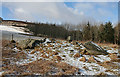
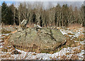
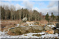
dawn50 visited on 1st Sep 2014 - their rating: Cond: 2 Amb: 2 Access: 1 This circle is all but invisible because of lack of care, ive been out to vist it on a few ocaisions since 2002. very sad :-(
")
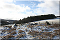
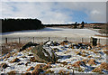
This stone circle is in danger of disappearing forever as the farmer appears to be dumping piles of stones from the fields on top of the already fallen circle stones. It is in an impressive setting on the hillside.
You may be viewing yesterday's version of this page. To see the most up to date information please register for a free account.
")
")
Do not use the above information on other web sites or publications without permission of the contributor.
Nearby Images from Geograph Britain and Ireland:
©2016(licence)
©2016(licence)
©2016(licence)
©2016(licence)
©2016(licence)
The above images may not be of the site on this page, they are loaded from Geograph.
Please Submit an Image of this site or go out and take one for us!
Click here to see more info for this site
Nearby sites
Key: Red: member's photo, Blue: 3rd party photo, Yellow: other image, Green: no photo - please go there and take one, Grey: site destroyed
Download sites to:
KML (Google Earth)
GPX (GPS waypoints)
CSV (Garmin/Navman)
CSV (Excel)
To unlock full downloads you need to sign up as a Contributory Member. Otherwise downloads are limited to 50 sites.
Turn off the page maps and other distractions
Nearby sites listing. In the following links * = Image available
5.8km ENE 69° Bowman Hillock* Stone Circle (NJ480398)
6.7km NE 39° Gingomyres Stone Circle (NJ46794294)
7.5km SSE 161° Wormy Hillock* Henge (NJ449307)
8.1km NW 322° St Fumac's Well* Holy Well or Sacred Spring (NJ376443)
9.4km E 100° Hill Of Bucharn Stone Circle (NJ518360)
9.7km N 0° Tobar na Cailleach Holy Well or Sacred Spring (NJ4265947528)
10.2km W 277° Mortlach 1* Class II Pictish Symbol Stone (NJ32413924)
10.3km W 277° Mortlach 2* Class I Pictish Symbol Stone (NJ323392)
10.3km SE 144° Tap o'Noth* Hillfort (NJ484293)
10.6km ENE 78° Stannin Steens O Strathbogie* Class I Pictish Symbol Stone (NJ529399)
10.6km ENE 78° Huntly Stone Circle (NJ529399)
11.0km W 271° Nether Cluny* Stone Circle (NJ315381)
11.9km ENE 78° Battle Hill Dolmen Cairn (NJ542401)
12.4km SSE 151° Upper Ord* Stone Circle (NJ484269)
12.4km SSE 153° Wheedlemont* Stone Circle (NJ4797226606)
12.7km SE 141° Mill o'Noth* Standing Stones (NJ5034727801)
12.9km SE 145° Rhynie 2* Class I Pictish Symbol Stone (NJ49802715)
13.0km SE 145° Rhynie 4* Class I Pictish Symbol Stone (NJ49822700)
13.1km SE 124° Candy* Stone Circle (NJ533303)
13.1km NE 53° Arnhill* Stone Circle (NJ531456)
13.4km SE 146° Rhynie 6* Class I Pictish Symbol Stone (NJ49972659)
13.5km SSE 147° Rhynie Man* Class I Pictish Symbol Stone (NJ49762636)
13.5km SSE 147° Craw Stane* Class I Pictish Symbol Stone (NJ4974926345)
13.6km SSE 147° Rhynie 8* Class I Pictish Symbol Stone (NJ497262)
13.6km SE 141° Corrstone Wood* Stone Circle (NJ510271)
View more nearby sites and additional images


 We would like to know more about this location. Please feel free to add a brief description and any relevant information in your own language.
 Wir möchten mehr über diese Stätte erfahren. Bitte zögern Sie nicht, eine kurze Beschreibung und relevante Informationen in Deutsch hinzuzufügen.
 Nous aimerions en savoir encore un peu sur les lieux. S'il vous plaît n'hesitez pas à ajouter une courte description et tous les renseignements pertinents dans votre propre langue.
 Quisieramos informarnos un poco más de las lugares. No dude en añadir una breve descripción y otros datos relevantes en su propio idioma.