

<< Our Photo Pages >> The Kirkstone - Natural Stone / Erratic / Other Natural Feature in England in Cumbria
Submitted by Postman on Tuesday, 22 March 2022 Page Views: 712
Natural PlacesSite Name: The KirkstoneCountry: England County: Cumbria Type: Natural Stone / Erratic / Other Natural Feature
Nearest Town: Ambleside Nearest Village: Hartsop
Map Ref: NY402086
Latitude: 54.469228N Longitude: 2.92419W
Condition:
| 5 | Perfect |
| 4 | Almost Perfect |
| 3 | Reasonable but with some damage |
| 2 | Ruined but still recognisable as an ancient site |
| 1 | Pretty much destroyed, possibly visible as crop marks |
| 0 | No data. |
| -1 | Completely destroyed |
| 5 | Superb |
| 4 | Good |
| 3 | Ordinary |
| 2 | Not Good |
| 1 | Awful |
| 0 | No data. |
| 5 | Can be driven to, probably with disabled access |
| 4 | Short walk on a footpath |
| 3 | Requiring a bit more of a walk |
| 2 | A long walk |
| 1 | In the middle of nowhere, a nightmare to find |
| 0 | No data. |
| 5 | co-ordinates taken by GPS or official recorded co-ordinates |
| 4 | co-ordinates scaled from a detailed map |
| 3 | co-ordinates scaled from a bad map |
| 2 | co-ordinates of the nearest village |
| 1 | co-ordinates of the nearest town |
| 0 | no data |
Internal Links:
External Links:
")
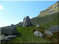
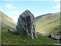
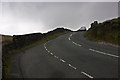
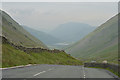
The massive monolith that gives Kirkstone pass it's name.
A car park lies just south of the big rock, a short but awkward path leads to the site.
From the north, on the road, the stone looks in profile like a church, or up here Kirk, hence the name.
From another aspect the stone looks like a horses head, from all others it looks like a big rock.
You may be viewing yesterday's version of this page. To see the most up to date information please register for a free account.
")
")
")
")
Do not use the above information on other web sites or publications without permission of the contributor.
Nearby Images from Geograph Britain and Ireland:
©2011(licence)
©2011(licence)
©2008(licence)
©2011(licence)
©2017(licence)
The above images may not be of the site on this page, they are loaded from Geograph.
Please Submit an Image of this site or go out and take one for us!
Click here to see more info for this site
Nearby sites
Key: Red: member's photo, Blue: 3rd party photo, Yellow: other image, Green: no photo - please go there and take one, Grey: site destroyed
Download sites to:
KML (Google Earth)
GPX (GPS waypoints)
CSV (Garmin/Navman)
CSV (Excel)
To unlock full downloads you need to sign up as a Contributory Member. Otherwise downloads are limited to 50 sites.
Turn off the page maps and other distractions
Nearby sites listing. In the following links * = Image available
2.5km ESE 113° Troutbeck Park Round Cairn 1* Round Cairn (NY4248407616)
2.5km ESE 112° Troutbeck Park Round Cairn 2* Round Cairn (NY4250707632)
2.7km ESE 107° Troutbeck Park Round Cairn 4* Round Cairn (NY4274707790)
2.7km ESE 108° Troutbeck Park Round Cairn 3* Round Cairn (NY4273707734)
3.0km N 352° Dovedale enclosure* Ancient Village or Settlement (NY398116)
3.1km SSE 151° Hird Wood* Stone Circle (NY41630589)
3.5km ENE 68° High Street Roman Road Ancient Trackway (NY43470988)
4.1km SW 232° Rydal Hall Cup Marks Rock Art (NY369061)
4.6km SSW 214° The Armitt* Museum (NY376048)
5.3km E 95° The Ull Stone Natural Stone / Erratic / Other Natural Feature (NY455081)
6.0km SSW 209° Ambleside Roman Fort* Ancient Village or Settlement (NY37260339)
6.4km W 262° Grasmere Cup-Marked Rocks* Rock Art (NY33850778)
6.4km N 0° Beckstones* Rock Art (NY403150)
6.4km N 1° Beckstones Rock Art Ring Cairn (NY404150)
6.5km W 281° Mêni Arthur Natural Stone / Erratic / Other Natural Feature (NY338099)
6.9km W 261° Allan Bank Cup Marked Stone* Rock Art (NY334076)
7.9km ENE 57° Castle Crag Hillfort* Hillfort (NY4692412763)
8.1km WNW 292° Dunmail Raise* Round Cairn (NY32721170)
8.1km N 349° St Patrick's Well (Patterdale)* Holy Well or Sacred Spring (NY388166)
8.4km SSE 154° Hughill* Ancient Village or Settlement (NY4373900980)
9.2km WSW 252° Copt Howe* Rock Art (NY31400583)
9.7km SSE 165° Bannerrigg Possible Standing Stone* Standing Stone (Menhir) (SD426992)
9.7km WSW 240° Little Langdale Cup-Marked Stone* Rock Art (NY317038)
9.8km W 277° Grasmere - Far Easedale* Natural Stone / Erratic / Other Natural Feature (NY305099)
10.3km NNE 17° St Martin’s Church (Martindale)* Sculptured Stone (NY43431840)
View more nearby sites and additional images


 We would like to know more about this location. Please feel free to add a brief description and any relevant information in your own language.
 Wir möchten mehr über diese Stätte erfahren. Bitte zögern Sie nicht, eine kurze Beschreibung und relevante Informationen in Deutsch hinzuzufügen.
 Nous aimerions en savoir encore un peu sur les lieux. S'il vous plaît n'hesitez pas à ajouter une courte description et tous les renseignements pertinents dans votre propre langue.
 Quisieramos informarnos un poco más de las lugares. No dude en añadir una breve descripción y otros datos relevantes en su propio idioma.