 with our Megalithic Portal iPhone app")

<< Our Photo Pages >> Castle Ring (Shropshire) - Misc. Earthwork in England in Shropshire
Submitted by TheWhiteRider on Sunday, 04 June 2006 Page Views: 6341
Multi-periodSite Name: Castle Ring (Shropshire)Country: England
NOTE: This site is 3.4 km away from the location you searched for.
County: Shropshire Type: Misc. Earthwork
Nearest Town: Craven Arms Nearest Village: Edgton
Map Ref: SO40128689
Latitude: 52.476638N Longitude: 2.883049W
Condition:
| 5 | Perfect |
| 4 | Almost Perfect |
| 3 | Reasonable but with some damage |
| 2 | Ruined but still recognisable as an ancient site |
| 1 | Pretty much destroyed, possibly visible as crop marks |
| 0 | No data. |
| -1 | Completely destroyed |
| 5 | Superb |
| 4 | Good |
| 3 | Ordinary |
| 2 | Not Good |
| 1 | Awful |
| 0 | No data. |
| 5 | Can be driven to, probably with disabled access |
| 4 | Short walk on a footpath |
| 3 | Requiring a bit more of a walk |
| 2 | A long walk |
| 1 | In the middle of nowhere, a nightmare to find |
| 0 | No data. |
| 5 | co-ordinates taken by GPS or official recorded co-ordinates |
| 4 | co-ordinates scaled from a detailed map |
| 3 | co-ordinates scaled from a bad map |
| 2 | co-ordinates of the nearest village |
| 1 | co-ordinates of the nearest town |
| 0 | no data |
Internal Links:
External Links:
I have visited· I would like to visit
TheWhiteRider has visited here
 (PID:21168)")
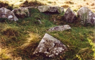
The remains of a roughly triangular fortified Iron Age farmstead or possibly a small promontary fort constructed on high ground above the River Onny valley. The location of Castle Ring is now in the corner of a field adjoining Plowden Woods and is visible from the footpath.
Unfortunately on this visit the field was a hay meadow and nothing of the site could be seen. We even walked a little way along the field boundary towards the location and could neither see or find any trace of earthworks. A post harvest or Winter visit might prove more useful.
You may be viewing yesterday's version of this page. To see the most up to date information please register for a free account.
 (PID:303209)")
 (PID:21169)")
Do not use the above information on other web sites or publications without permission of the contributor.
Nearby Images from Geograph Britain and Ireland:

©2017(licence)

©2017(licence)

©2017(licence)

©2017(licence)

©2015(licence)
The above images may not be of the site on this page, they are loaded from Geograph.
Please Submit an Image of this site or go out and take one for us!
Click here to see more info for this site
Nearby sites
Key: Red: member's photo, Blue: 3rd party photo, Yellow: other image, Green: no photo - please go there and take one, Grey: site destroyed
Download sites to:
KML (Google Earth)
GPX (GPS waypoints)
CSV (Garmin/Navman)
CSV (Excel)
To unlock full downloads you need to sign up as a Contributory Member. Otherwise downloads are limited to 50 sites.
Turn off the page maps and other distractions
Nearby sites listing. In the following links * = Image available
2.2km S 182° Wart Hill Camp* Hillfort (SO400847)
2.8km NNE 13° Botley Stone* Ring Cairn (SO408896)
4.1km SE 134° Belair Bowl Barrow* Round Barrow(s) (SO430840)
4.2km ESE 104° Strefford Henge Henge (SO442858)
4.3km SSW 206° Burrow Hill Camp (Shropshire)* Hillfort (SO3821083050)
5.1km SSE 146° Tumpy Hill Round Barrow(s) (SO429826)
5.5km SE 142° Secret Hills Discovery Centre* Museum (SO435825)
6.2km NNE 26° Cross Dyke Bowl Barrow South* Round Barrow(s) (SO42869241)
6.2km NNE 26° Cross Dyke Bowl Barrow North* Round Barrow(s) (SO42899244)
6.3km NNE 22° Barrister's Plain Cross Dyke* Ancient Village or Settlement (SO426927)
6.3km N 356° Robury Ring* Misc. Earthwork (SO39799321)
6.6km NNE 12° Long Mynd B* Round Barrow(s) (SO41539330)
6.8km SE 137° Norton Camp (Shropshire)* Hillfort (SO44728193)
7.1km N 7° Pole Cottage* Round Barrow(s) (SO411939)
7.4km NNE 31° Ashlet Hill Bowl Barrow Round Barrow(s) (SO440932)
7.9km SSW 201° Fairy Stone* Natural Stone / Erratic / Other Natural Feature (SO37237958)
8.0km NNE 17° Long Mynd A* Round Barrow(s) (SO426945)
8.0km NNE 15° Boiling Well (Long Mynd)* Round Barrow(s) (SO423946)
8.1km WSW 246° Bury Ditches (Shropshire)* Hillfort (SO327837)
8.3km NNE 27° The Devil's Mouth Cross Dyke* Misc. Earthwork (SO43959425)
8.5km NE 36° Stretton Sheela* Early Christian Sculptured Stone (SO45239368)
8.7km NNE 12° Shooting Box Disc Barrow* Round Barrow(s) (SO421954)
8.9km NNE 13° Long Mynd C* Round Barrow(s) (SO423955)
8.9km SSW 205° Hopton Castle Standing Stone (Menhir) (SO36297883)
8.9km NNE 29° Bodbury Ring* Hillfort (SO445947)
View more nearby sites and additional images


 We would like to know more about this location. Please feel free to add a brief description and any relevant information in your own language.
 Wir möchten mehr über diese Stätte erfahren. Bitte zögern Sie nicht, eine kurze Beschreibung und relevante Informationen in Deutsch hinzuzufügen.
 Nous aimerions en savoir encore un peu sur les lieux. S'il vous plaît n'hesitez pas à ajouter une courte description et tous les renseignements pertinents dans votre propre langue.
 Quisieramos informarnos un poco más de las lugares. No dude en añadir una breve descripción y otros datos relevantes en su propio idioma.