<< Other Photo Pages >> Dorstone Hill - Ancient Village or Settlement in England in Herefordshire

Submitted by SolarMegalith on Friday, 12 August 2022  Page Views: 30810

Neolithic and Bronze AgeSite Name: Dorstone Hill
Country: England
NOTE: This site is 0.2 km away from the location you searched for.

County: Herefordshire Type: Ancient Village or Settlement
Nearest Town: Hay-on-Wye
Map Ref: SO32604230
Latitude: 52.074943N  Longitude: 2.984823W
Condition:
5Perfect
4Almost Perfect
3Reasonable but with some damage
2Ruined but still recognisable as an ancient site
1Pretty much destroyed, possibly visible as crop marks
0No data.
-1Completely destroyed
2 Ambience:
5Superb
4Good
3Ordinary
2Not Good
1Awful
0No data.
3 Access:
5Can be driven to, probably with disabled access
4Short walk on a footpath
3Requiring a bit more of a walk
2A long walk
1In the middle of nowhere, a nightmare to find
0No data.
no data Accuracy:
5co-ordinates taken by GPS or official recorded co-ordinates
4co-ordinates scaled from a detailed map
3co-ordinates scaled from a bad map
2co-ordinates of the nearest village
1co-ordinates of the nearest town
0no data
5

Internal Links:
External Links:

I have visited· I would like to visit

SumDoood Chriski would like to visit

Andy B has visited here
Dorstone Hill
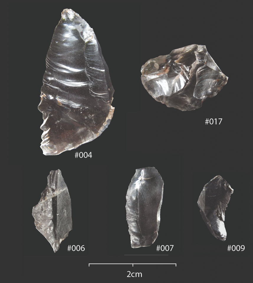
Dorstone Hill submitted by dodomad : New paper on Neolithic Rock Crystal from Dorstone Hill, Open Access in Cambridge Archaeological Journal Not All That Glitters is Gold? Rock Crystal in the Early British Neolithic at Dorstone Hill, Herefordshire, and the Wider British and Irish Context Evidence for working rock crystal, a rare form of water-clear type of quartz, is occasionally recovered from prehistoric sites in Britain ... (Vote or comment on this photo)
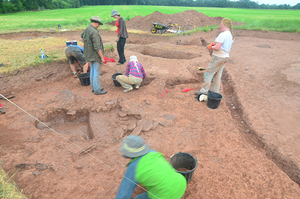
Remains of Neolithic enclosed settlement and later Bronze Age earthwork. First excavated in 1965-1970 and 1995. Suffered much damage from the plough. Nearby are the remains of two large 6000-year-old halls, each buried within a neolithic long barrow. More recently excavated by archaeologists from The University of Manchester and Herefordshire Council between approx 2015-2019.

Official Web Site and see the latest Dig Diary

Note: New paper on rock crystal at Dorstone Hill: "Far from being used to make tools, we argue the distinctive material was being used to create distinctive and memorable moments, binding individuals together, forging local identities, and connecting the living and the dead."
You may be viewing yesterday's version of this page. To see the most up to date information please register for a free account.

Dorstone Hill
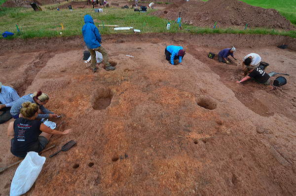
Dorstone Hill submitted by rexh : The elongated hall showing the four excavated post holes, the burnt ground and palisade (the long trenches to the left and right) of the hall or longhouse. it was then covered, originally by turf to become the longbarrow and then later with stone. burial cists were added indicating the site continued to be venerated over a long period. (Vote or comment on this photo)

Dorstone Hill
Dorstone Hill submitted by Adam Stanford : Excavations at Dorstone Hill in the UK centered around a pair of nearly 6,000-year-old set of burial mounds that were created from the ashes of an ancient long hall. Image credit: Adam Stanford - Copyright © Aerial-Cam Ltd 2013 - Licensed to University of Manchester. (Vote or comment on this photo)

Dorstone Hill
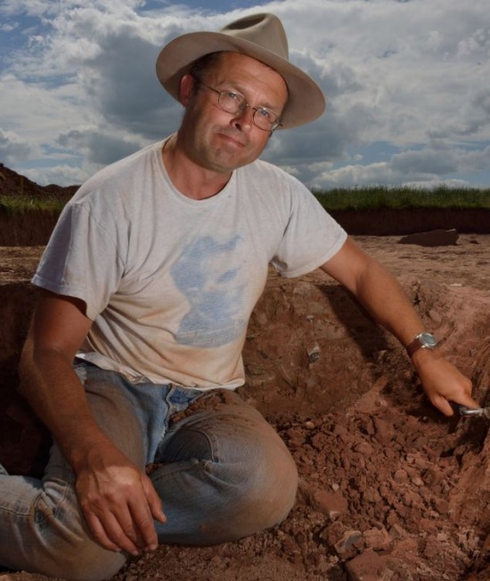
Dorstone Hill submitted by Adam Stanford : Julian Thomas, professor of archaeology at the University of Manchester co-led the Dorstone Hill excavation Image credit: Adam Stanford - Copyright © Aerial-Cam Ltd 2013 - Licensed to University of Manchester. (1 comment - Vote or comment on this photo)

Dorstone Hill
Dorstone Hill submitted by rexh : One of the later burial cists. (professor Julian Thomas in the background) interview link http://ruvr.co.uk/2013_07_30/dead-found-Herefordshire/ (Vote or comment on this photo)

Dorstone Hill
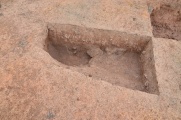
Dorstone Hill submitted by rexh : The post holes of one of two excavated halved tree trunks which are suspected of supporting a trough (for carrying the dead) and held between the two.

Dorstone Hill
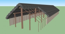
Dorstone Hill submitted by dodomad : A reconstruction of what one of the long halls would have looked like Image Credit: Henry Rothwell, University of Manchester

Dorstone Hill
Dorstone Hill submitted by Adam Stanford : This flaked flint knife was found in a cremation pit dug into the side of one of the two long barrows. Image credit: Adam Stanford - Copyright © Aerial-Cam Ltd 2013 - Licensed to University of Manchester. (1 comment)

Do not use the above information on other web sites or publications without permission of the contributor.
Click here to see more info for this site

Nearby sites

Click here to view sites on an interactive OS map

Key: Red: member's photo, Blue: 3rd party photo, Yellow: other image, Green: no photo - please go there and take one, Grey: site destroyed

Download sites to:
KML (Google Earth)
GPX (GPS waypoints)
CSV (Garmin/Navman)
CSV (Excel)

To unlock full downloads you need to sign up as a Contributory Member. Otherwise downloads are limited to 50 sites.


Turn off the page maps and other distractions

Nearby sites listing. In the following links * = Image available
 872m SE 134° Great Llanavon Farm* Long Barrow (SO3322441689)
 945m NE 35° Pentre House Standing Stone* Standing Stone (Menhir) (SO33154307)
 1.1km NW 318° Arthur's Stone* Chambered Tomb (SO3188843124)
 1.8km W 269° The Golden Well (Dorstone)* Holy Well or Sacred Spring (SO30804228)
 2.0km N 353° Chapel field Hillfort (SO32404425)
 2.4km NNE 21° Bredwardine Church* Carving (SO33484450)
 2.4km N 356° The Knapp (Bredwardine)* Ancient Village or Settlement (SO32454467)
 3.8km ESE 108° Blakemere Church Stone* Marker Stone (SO362411)
 4.4km SE 141° Peterchurch St Peter's Well* Holy Well or Sacred Spring (SO35333880)
 4.7km ESE 102° Holy Well (Blakemere)* Holy Well or Sacred Spring (SO37254128)
 5.5km SSW 203° Wern Derys* Standing Stone (Menhir) (SO30363726)
 5.7km SE 143° Poston Camp Hillfort (SO3598937647)
 7.8km NW 311° St Peter's Well, Whitney on Wye* Holy Well or Sacred Spring (SO268475)
 8.3km SE 132° Timberline Camp Hillfort (SO387367)
 9.2km WSW 246° Twyn-Y-Beddau* Round Barrow(s) (SO2414838610)
 9.8km WSW 242° Maes-Coch Chambered Cairn (SO239378)
 10.0km WSW 239° Pen Y Beacon* Stone Circle (SO23933735)
 10.1km W 269° The Walk Well* Holy Well or Sacred Spring (SO225422)
 10.1km W 274° The Monk's Well* Holy Well or Sacred Spring (SO225432)
 10.4km WSW 256° Pen-y-Wyrlod* Chambered Tomb (SO22483987)
 10.7km SE 142° Dunseal* Round Barrow(s) (SO391338)
 11.1km SSW 201° St. Thomas' Well* Holy Well or Sacred Spring (SO28433201)
 11.1km E 92° Holy Well (Swainshill)* Holy Well or Sacred Spring (SO43724177)
 11.2km S 191° Llanveyno Crosses* Ancient Cross (SO3031131361)
 11.2km WNW 287° Crossfoot Farm Standing Stone* Standing Stone (Menhir) (SO21874573)
View more nearby sites and additional images

<< Husbands Bosworth Causewayed Enclosure

The Bore Stone >>

Please add your thoughts on this site

Kilmartin Sounds of Ancient Scotland Ancient Music CD

Kilmartin Sounds of Ancient Scotland Ancient Music CD

Sponsors

Auto-Translation (Google)

Translate from English into:

"Dorstone Hill" | Login/Create an Account | 21 News and Comments
  
Go back to top of page    Comments are owned by the poster. We aren't responsible for their content.
Not All That Glitters is Gold? Rock Crystal in the Early British Neolithic by Andy B on Thursday, 11 August 2022
(User Info | Send a Message)
New paper on Neolithic Rock Crystal from Dorstone Hill, Open Access in Cambridge Archaeological Journal

Not All That Glitters is Gold? Rock Crystal in the Early British Neolithic at Dorstone Hill, Herefordshire, and the Wider British and Irish Context

Evidence for working rock crystal, a rare form of water-clear type of quartz, is occasionally recovered from prehistoric sites in Britain and Ireland, however, very little has been written on the specific methods of working this material, and its potential significance in the past. This paper presents the first synthesis of rock crystal evidence from Britain and Ireland, before examining a new assemblage from the Early Neolithic site of Dorstone Hill, Herefordshire.

This outlines a methodology for analysing and interpreting this unusual material, and, through comparison with the flint assemblage, examines the specific uses and treatments of this material. Far from being used to make tools, we argue the distinctive and exotic rock crystal was being used to create distinctive and memorable moments, binding individuals together, forging local identities, and connecting the living and the dead.

https://doi.org/10.1017/S0959774322000142
[ Reply to This ]

Dorstone Hill - The 2018 season begins, and weekly talk details on Wednesday evenings by Andy B on Wednesday, 27 June 2018
(User Info | Send a Message)
The 2018 season begins!

Cat Langham writes: I’m part of the excavations at Dorstone Hill, and will be keeping you up to date with what we’re doing over the next few weeks! We’ll be keeping you updated with pictures of how excavations are coming along, info from the site, and general news of what we’re all up to at https://dorstonedigs.wordpress.com

As usual, there will a series of lectures held in Dorstone Village hall, so do come along to find out more about the site and surrounding area!
Talks start at 7.30 and are £1 on the door.

This year we have:

Wednesday 27th June
‘Dorstone Hill in Neolithic Britain: A landscape of national significance’
Professor Julian Thomas

Wednesday 4th July
‘How much do we really know about Arthur’s Stone?’
Dr. Keith Ray

Wednesday 11th July
‘Dealing with the dead at Dorstone Hill’
(plus an update on the Rock Crystal analysis)
Dr. Nick Overton

Wednesday 18th July
‘Dorstone Hill in 2018: an interim overview’
Professor Julian Thomas


Dorstone Hill is a site of special archaeological significance, and we’re excited to be back excavating this year. Between 2011-2016 we found three amazing Neolithic long barrows, placed end to end, a rare monument arrangement. Each was made in a distinct style, the Eastern featuring a timber chamber between huge post-holes, the Central being surrounded by a timber palisade, and the Western being surrounded by a dry-stone wall. All three were topped off with a stone cairn, but the different styles may show different groups gathered here and created their own unique designs.

Even more significantly, under each mound was found the remains of a burnt timber hall. This mysterious process is called domicide, and to burn buildings around 40 metres long would have taken a lot of effort! With the location of the hill between the Golden and Wye Valleys, the burning would have been a very visible beacon that lasted for days.

This may have been an act of creating memories, with the later mounds solidifying this community memory, and marking the area as a special place.

Dorstone Hill is a complex site, and has even more to offer archaeologists than the amazing long mounds. A little higher on the hill, geophysics showed what looked like a Causewayed Enclosure, a large Neolithic feature, which may have been a large gathering place. Last year we began to investigate this feature, and last year’s blog posts are a great place to find out all the details of the 2017 season. This year we’re back to see what else it can tell us!

Read more at
https://dorstonedigs.wordpress.com/2018/06/27/the-2018-season-begins/
[ Reply to This ]
    Re: Dorstone Hill - The 2018 season begins, and weekly talk details on Wednesday even by Andy B on Tuesday, 03 July 2018
    (User Info | Send a Message)
    DORSTONE HILL OPEN DAY 2018
    Will be on Sunday 15th July - 10:00 am - 4:00 pm

    So, what are we looking for?

    This year we’re excavating a causewayed enclosure, a type of Neolithic space made up of many ditches, which enclose a circular space. These have lots of gaps, or causeways, so we know they can’t be for defence! It’s thought they were used as meeting and gathering places for people to come together, explaining the long-distance trade we’ve found evidence for at Dorstone (with things like flint travelling from Cornwall and Wales).

    Read more at
    https://dorstonedigs.wordpress.com/2018/07/02/so-what-are-we-looking-for/
    [ Reply to This ]

Re: Dorstone Hill by Andy B on Thursday, 04 January 2018
(User Info | Send a Message)
The 2017 excavations confirmed that the structure at SO 3271 4216 - previously thought to be an Iron Age promontory enclosure is actually a fourth long mound - neatly surrounded by a causewayed enclosure. The bank extends for 71 metres straight, 7 metres at the base and 1.7m) high.

Previous site description here
http://www.pastscape.org.uk/hob.aspx?hob_id=106120
[ Reply to This ]

Rock Crystal at Dorstone Hill by Andy B on Thursday, 13 July 2017
(User Info | Send a Message)
... last, but by no means least, was the evening lecture by Nick. He drew a full house of both villagers and students for his talk on the work he and Irene, one of the project’s associate directors, are doing on Rock Crystal. It seems that the site of top of Dorstone Hill is, as far as we know, unique. There is nowhere in the country that has a Neolithic site with some much Rock Crystal! Nick and Irene are currently looking at ways of recording and analysing the finds and producing a report on their work. A generous round of applause was an apt reward for a really interesting talk! Thank you again Nick!

https://dorstonedigs.wordpress.com/2017/07/13/day-16-wednesday-12th-july/
[ Reply to This ]

Dorstone Hill 2017 Dig Diary Blog underway by Andy B on Thursday, 06 July 2017
(User Info | Send a Message)
The Dorstone Hill 2017 Dig Diary Blog is underway here

Day 9:
Work on excavating the ditch of the causewayed enclosure has now begun. There are several segments of ditch in the trench that have now been exposed. Sometimes these ditches were re-dug in the Neolithic, exactly why we don’t know, but there are as you might imagine many theories on this. By the end of the day the first few centimetres of ditch fill had been removed as the team were looking to find the edges.

Julian was really pleased to see several finds emerging so early in proceedings, including a nice piece of flint he found himself! What made this flint so noticeable was the signs of what archaeologists call ‘re-touch’ where someone has removed small flakes from one side, producing a sharp edge which could be used for cutting or scraping.

More at

https://dorstonedigs.wordpress.com/
also
https://web.facebook.com/groups/1072781332781702/
[ Reply to This ]
    Re: Dorstone Hill 2017 Dig Diary Blog underway by Andy B on Friday, 07 July 2017
    (User Info | Send a Message)
    Julian Thomas says: We have an open day on Sunday 16th July, but it's fine to come and have a look any day apart from Saturday.
    [ Reply to This ]

An Interim Report on Excavations at Dorstone Hill, Herefordshire, 2011-14 by Andy B on Monday, 05 September 2016
(User Info | Send a Message)
Investigations at Dorstone Hill in the parish of Dorstone in the Dore Valley, Herefordshire, have taken place annually since 2011, with the aim of investigating Neolithic settlement in the area just to the south of the chambered tomb of Arthur’s Stone. The project has been directed by Professor Julian Thomas of Manchester University and Dr. Keith Ray, formerly County Archaeologist with Herefordshire Council, in association with Professor Koji Mizoguchi, of Kyushu University, Japan, and Tim Hoverd of Herefordshire Council. The project has deployed local volunteers and students from (mostly) the Universities of Manchester, Kyushu and Cardiff. Irene Garcia-Rovira, Ellen McInnes and Lara Bishop of the University of Manchester have supervised the work in the field during all four seasons.

The hilltop at Dorstone Hil is a promontory extending south-westwards from the ridge separating the Dore and Wye valleys east of Hay-on-Wye. The field occupying the hilltop was cleared of scrub and levelled to be brought into cultivation during the Second World War, and had, by the 1960s, produced a significant assemblage of worked flints. The site was test-excavated by Roger Pye and members of the Woolhope Naturalists’ Field Club in the 1960s, and was provisionally classified as a Neolithic hilltop enclosure. The low earthen bank that extends east-west for 120m across the narrow neck of the promontory was surveyed by English Heritage in the late 1990s, and it was concluded that it was a defining feature of the putative enclosure.

In 2011, a trench was dug across the bank where it appeared to survive best, close to its eastern limit, and well to the east of a putative entrance gap. No ditch accompanying the bank was found, but a historically-recent quarry was intercepted. The bank itself was found to comprise large stone slabs on its north-facing side, and burnt clay on its crest. A pit containing sherds of Neolithic pottery was found on the southern side of the bank. In 2012, a trench opened to the west of the ‘entrance gap’ revealed that the bank was covered on both northern and southern sides with a capping of stones, and a stone-lined cist, with a broken leaf-shaped arrowhead, was uncovered on the northern side. Again, no ditch was evident, and a burnt deposit was found within two parallel lines of palisade slots.

In 2013, this trench was further investigated and the burnt deposit was seen to cover the remains of a timber aisled hall. It was deduced that this had burned down and that the burnt clay was super-structural daub. Structural timbers were recorded, decayed from charred posts and woodwork. Also in 2013, a further trench was excavated between the eastern and western mounds. A pit containing distinctive flint items of likely Late Neolithic date was found to have been dug into the top of the eastern mound, close to where a rectangular mortuary chamber of Early Neolithic character (large upright timber posts linked by a stone-lined trough) had previously been dug into the subsoil. An early Neolithic axe was found, albeit displaced by a modern drain, immediately west of this chamber. Further finds included the eastern end of the aisled building intercepted in the 2012-13 trench, and a series of Bronze Age deposits apparently located deliberately to reference the earlier features.

In 2014, a further trench was opened across what had been supposed was the western end of the western of two long mounds. This revealed a third long mound that had been created in similar sequence to the central mound, with a burnt deposit then capped by turf. It was, however, retained within a stone wall (lost to bulldozing along its southern side) that had formed the basis for a ‘Cotswold-Severn’-style cairn that included modest side-chambers. The eastern end of this trapezoidal cairn had been reinforced with stone buttressing before all three mounds were linked by further stonework. In 2015, planned excavations will complete the investigation of this western mound/cairn.


Read the rest of this post...
[ Reply to This ]
    Re: An Interim Report on Excavations at Dorstone Hill, Herefordshire, 2011-14 by Anonymous on Monday, 07 January 2019
    Hello Andy, I trust you are still to some extent involved it this very interesting project.

    I intent to visit Dorstone at the beginning of February this year and although not involved in any aspect of archaeology I am enthusiastic to learn more about our Neolithic ancestors and their incredible achievements.

    I would be grateful for any information you may be able to provide concerning the excavations on Dorstone Hill.

    Thank you.

    With regards,

    Tom Beeson
    [ Reply to This ]
      Re: An Interim Report on Excavations at Dorstone Hill, Herefordshire, 2011-14 by Andy B on Tuesday, 08 January 2019
      (User Info | Send a Message)
      Hello Tom, no I've just been pulling together the publicly available information on the dig, I think I have most of it covered in the links on this page. If you want to ask them any information see the Facebook group I've linked to which is where they hang out.
      Thanks
      Andy
      [ Reply to This ]

An Interim Report on Excavations at Dorstone Hill, Herefordshire in 2012 by Andy B on Monday, 05 September 2016
(User Info | Send a Message)
This report discusses the results of excavations led by the University of Manchester at the hilltop site of Dorstone Hill, Herefordshire; SO 3260 4230

The project forms part of an on-going joint partnership between the University of Manchester and Hereford Archaeology that seeks to investigate prehistoric remains within the southwest of Herefordshire. The investigations particularly aim to improve the general knowledge of early Neolithic activity within the region. This report discusses the second year of excavations at Dorstone Hill which fall within the third year of this wider project. In its first year investigations centred on the English/Welsh border within the Olchon Valley where the partnership identified a late Neolithic/early Bronze Age a complex burial site. In 2011 three sites saw trial investigations to establish the nature of the prehistoric archaeology (see Bishop and Atkinson 2011; Garcia-Rovira et al 2011; Thomas and McInnes 2011).

Following the discovery of Neolithic material during prior excavations at the hilltop site of Dorstone Hill and the discovery of possible features on aerial photographs the site was targeted for trial excavation. Over the course of July 2011 a long exploratory trench was opened which identified both artefacts and features suggesting Neolithic activity at the site. In 2012 a larger trench was opened across the previously identified earthwork to fully investigate the nature of the archaeology. The results of this work confirmed observations from the evaluation trench and allowed for the make-up of the earthwork to be examined in more detail and a sequence of construction is suggested. A possible cist was also identified but requires further investigation. The finds associated with the earthwork suggest that it is of Neolithic date.

https://www.academia.edu/28224696/An_Interim_Report_on_Excavations_at_Dorstone_Hill_Herefordshire_in_2012
[ Reply to This ]

Dorstone Hill excavations on Facebook by Andy B on Tuesday, 12 November 2013
(User Info | Send a Message)
Dorstone Hill excavations on Facebook
2015: http://www.facebook.com/groups/204541099702466/

2016: https://www.facebook.com/groups/1072781332781702/
Report in the Prehistoric Society PASR 70 April 2012
[ Reply to This ]

Re: Dorstone Hill Street View by Anonymous on Sunday, 04 August 2013
" I am always sceptical about newspaper/TV/Radio reporting which rarely reports academic reasoning fully - "

They never report anything fully. I understand why this is but it means that they have no credibility.
[ Reply to This ]

Re: Dorstone Hill Street View by 4clydesdale7 on Saturday, 03 August 2013
(User Info | Send a Message)
As may be gathered from other postings I have made on sites in the area I spent an excellent time in Dorstone at the end of May this year - lots of superb sites to see - I walked over this site to visit the Dorstone Hill (Promontory) Fort just to the southeast (under the dark green trees on the main photograph of this site) - as a result the recent postings about this 'find' readily caught my eye -

I do not doubt the physical evidence discovered by the excavation teams and I accept that I have not read any academic paper/report of the recent excavations but I am concerned about the theory that has been brought forward - may I issue a 'caveat'? - I am always sceptical about newspaper/TV/Radio reporting which rarely reports academic reasoning fully -

So what do we know? The principle seems 'uncomplicated' - A Burial Barrow had been built over the site of a large timber building which had been reduced to ashes by fire - the remaining 'knowledge' is really only 'opinion' -

What evidence is there that the fire was deliberate? - How many people (if any) perished in the fire? What evidence is there that those who built the Barrow even knew about the former existence of the building? If they did how did they come by the knowledge? Did they know any one who perished in the fire or was there some community or familial knowledge (even folklore) of the circumstances of the fire and those who may have perished therein?

Families like to be buried in the same plot or mentioned on the same family memorial - particularly if there was some connecting tragedy to memorialise - like our forbears having been victims in some dreadful accident - we forget that Christians adopted many Pagan beliefs and practices - so there may be nothing new in the idea of a Family Grave and Memorial -

Why does the theory have to be more convoluted? And the theory supposedly supported by the discovery of stone axes could be a 'red herring' - which theory are you entitled to adopt? (a) did somebody arrive with axes to barter? or (b) did someone who had heard of them go off to find them and then bring them back? Both theories are equally plausible

I think we should await, with eager anticpation, the full academic report - there is already considerable evidence in the area of early settlement - Barrows, Promontory Forts, Camps, Hillforts, Holloways, Settlements, Ancient Standing Stones, Wells, Springs etc - and thus much for us to enjoy
[ Reply to This ]

Interview with Julian Thomas by Andy B on Thursday, 01 August 2013
(User Info | Send a Message)
Scott Craig from Voice of Russia spoke to Professor Julian Thomas about the significance of the find.
http://ruvr.co.uk/2013_07_30/dead-found-Herefordshire/

with thanks to RexH for the link
[ Reply to This ]

Re: Dorstone Hill by Andy B on Wednesday, 31 July 2013
(User Info | Send a Message)
The find was uncovered in an open field near Dorstone Hill, Herefordshire in the UK. For decades, amateur archaeologists have noticed pieces of flint blades in the area and wondered whether the land there contained relics of a long-forgotten time.

When Thomas and his team began excavating, they found two large burial mounds, or barrows, that could have held anywhere from seven to 30 people each. [See the nearby sites list]

The smaller barrow contained a 23-foot-long (7 meter) mortuary chamber with sockets for two huge tree trunks. Digging deeper, the researchers uncovered postholes, ash from the timbers, and charred clay from the walls of an ancient structure.

These burnt remains came from what were once two long-halls, the biggest of which was up to 230 feet (70 m) long, with aisles delineated by wooden posts and several internal spaces.

More at
http://www.livescience.com/38546-hall-of-dead-unearthed-england.html
[ Reply to This ]

Two 6000-year-old ‘halls of the dead’ unearthed, each within a prehistoric mound by Andy B on Wednesday, 31 July 2013
(User Info | Send a Message)

The remains of two large 6000-year-old halls, each buried within a prehistoric burial mound, have been discovered by archaeologists from The University of Manchester and Herefordshire Council – in a UK first.

The sensational finds on Dorstone Hill, near Peterchurch in Herefordshire, were thought to be constructed between 4000 and 3600 BC. Some of the burnt wood discovered at the site shows the character of the building’s structure above ground level- in another UK first.

The buildings, probably used by entire communities, are of unknown size, but may have been of similar length to the Neolithic long barrows beneath which they were found – 70metres and 30m long.

They were, say the team, deliberately burnt down after they were constructed and their remains incorporated into the two burial mounds. [see the nearby sites list]

However much detail has been preserved in the larger barrow: structural timbers in carbonized form, postholes showing the positions of uprights, and the burnt remains of stakes forming internal partitions.

Most importantly, the core of each mound is composed of intensely burnt clay, representing the daub from the walls of the buildings.

The buildings were likely to have been long structures with aisles, framed by upright posts, and with internal partitions. The smaller barrow contains a 7m by 2.5m mortuary chamber, with huge sockets which would have held upright tree trunks at each end. These massive posts bracketed a linear ‘trough’ lined with planks, which would have held the remains of the dead.

Professor of archaeology from The University of Manchester Julian Thomas and Dr Keith Ray Herefordshire Council’s County Archaeologist, co-directed the excavation.

Professor Thomas said: “This find is of huge significance to our understanding of prehistoric life- so we’re absolutely delighted. It makes a link between the house and a tomb more forcefully than any other investigation that has been ever carried out. These early Neolithic halls are already extremely rare, but to find them within a long barrow is the discovery of a lifetime.”

He added: “The mound tells us quite a bit about the people who built it: they sought to memorialize the idea of their community represented by the dwelling. And by turning it into part of the landscape, it becomes a permanent reminder for generations to come. Just think of how the burning of the hall could have been seen for miles around, in the large expanse of what is now the border country between England and Wales.”

Archaeologists have long speculated that a close relationship existed between houses and tombs in Neolithic Europe, and that ‘houses of the dead’ amounted to representations of the ‘houses of the living’.

In addition to the two long mounds, the site has provided evidence for a series of later burials and other deliberate deposits, including a cremation burial and a pit containing a flint axe and a finely-flaked flint knife.

The objects have close affinities with artefacts found in eastern Yorkshire in the Late Neolithic (c. 2600 BC).

Dr Ray said: “These subsequent finds show that 1000 years after the hall burial mounds were made, the site is still important to later generations living 200 miles away – a vast distance in Neolithic terms. The axe and knife may not have been traded, but placed there as part of a ceremony or an ancestral pilgrimage from what is now East Yorkshire. So we witness an interconnected community linking Herefordshire and East Yorkshire by marriage and by descent 5000 years ago.”

He added: “In the British context, the Dorstone find is unique and unprecedented. We were hoping our work with The University of Manchester would help us to give us a clearer picture of the origins of these long barrows- but we were surprised how clearly the story came through. It’s very exciting for us: for 15 years I have been arguing that Herefordshire has some

Read the rest of this post...
[ Reply to This ]

Re: Latest News on Dorstone Hill 'Halls of the Dead' by AngieLake on Wednesday, 31 July 2013
(User Info | Send a Message)
The Daily Mail has a good article here on the latest discoveries on Dorstone Hill:
http://www.dailymail.co.uk/sciencetech/article-2381487/Ancient-Dorstone-Hill-halls-dead-1-000-years-OLDER-Stonehenge.html

Quote:

"Ancient 'halls of the dead' pre-dating Stonehenge are being heralded by archaeologists as the first monuments of their kind to be found in the UK.
The two earth long barrows were uncovered on top of Dorstone Hill in Herefordshire and are thought to date to about 3,800BC, almost 1,000 years before the famous stone circle in Wiltshire was built, according to Professor Julian Thomas, of the University of Manchester.
Archaeologists who have spent a month excavating the mounds say they have removed fine examples of flint weapons and tools, thought to have been buried in the barrows when first created or later left as offerings to the dead."

(More on link, inc photos)

[ Reply to This ]

Dorstone Hill Neolithic sites dug by multi-national team by MikeAitch on Friday, 22 July 2011
(User Info | Send a Message)
Three Neolithic sites in Herefordshire are being investigated by a multi-national team of archaeologists.

The digs at Dorstone Hill and Bredwardine involve experts from Kyushu University in Japan, the University of Manchester and students from Sweden, Germany and Spain.

County archaeologist Dr Keith Ray said they wanted to know why people built earthworks and chambered tombs there.

"It's really a national question why they did it," he said.

The archaeologists are looking for settlements that were first suspected to be there in the 1960s.

The excavations on the hill top sites have so far found flints and pottery, as well as traces of a dry stone wall and a line of timbers.

Dr Ray said other information had been uncovered from local people.

"Even while we've been excavating here the locals have brought up photographs and have told us about stone axes which have come from different parts of the country and have been found locally," he said.

BBC News article with photo
[ Reply to This ]

Dorstone Hill Street View by Andy B on Saturday, 11 December 2010
(User Info | Send a Message)

View Larger Map
[ Reply to This ]

Your Name: Anonymous [ Register Now ]
Subject:


Add your comment or contribution to this page. Spam or offensive posts are deleted immediately, don't even bother

<<< What is five plus one as a number? (Please type the answer to this question in the little box on the left)
You can also embed videos and other things. For Youtube please copy and paste the 'embed code'.
For Google Street View please include Street View in the text.
Create a web link like this: <a href="https://www.megalithic.co.uk">This is a link</a>  

Allowed HTML is:
<p> <b> <i> <a> <img> <em> <br> <strong> <blockquote> <tt> <li> <ol> <ul> <object> <param> <embed> <iframe>

We would like to know more about this location. Please feel free to add a brief description and any relevant information in your own language.
Wir möchten mehr über diese Stätte erfahren. Bitte zögern Sie nicht, eine kurze Beschreibung und relevante Informationen in Deutsch hinzuzufügen.
Nous aimerions en savoir encore un peu sur les lieux. S'il vous plaît n'hesitez pas à ajouter une courte description et tous les renseignements pertinents dans votre propre langue.
Quisieramos informarnos un poco más de las lugares. No dude en añadir una breve descripción y otros datos relevantes en su propio idioma.