Featured: Friendly specialist tours to ancient, mystical and historical sites in the UK and beyond

Friendly specialist tours to ancient, mystical and historical sites in the UK and beyond

Random Image


Merrivale Centre N

Great Stone Circles, Aubrey Burl

Great Stone Circles, Aubrey Burl

Who's Online

There are currently, 263 guests and 0 members online.

You are a guest. To join in, please register for free by clicking here

Sponsors

<< Our Photo Pages >> Thrumster Mains - Broch or Nuraghe in Scotland in Caithness

Submitted by SolarMegalith on Thursday, 14 July 2011  Page Views: 8937

Iron Age and Later PrehistorySite Name: Thrumster Mains
Country: Scotland County: Caithness Type: Broch or Nuraghe
Nearest Town: Wick
Map Ref: ND3319545059
Latitude: 58.388823N  Longitude: 3.14431W
Condition:
5Perfect
4Almost Perfect
3Reasonable but with some damage
2Ruined but still recognisable as an ancient site
1Pretty much destroyed, possibly visible as crop marks
0No data.
-1Completely destroyed
3 Ambience:
5Superb
4Good
3Ordinary
2Not Good
1Awful
0No data.
3 Access:
5Can be driven to, probably with disabled access
4Short walk on a footpath
3Requiring a bit more of a walk
2A long walk
1In the middle of nowhere, a nightmare to find
0No data.
3 Accuracy:
5co-ordinates taken by GPS or official recorded co-ordinates
4co-ordinates scaled from a detailed map
3co-ordinates scaled from a bad map
2co-ordinates of the nearest village
1co-ordinates of the nearest town
0no data
5

Internal Links:
External Links:

I have visited· I would like to visit

SolarMegalith visited on 5th Jul 2011 - their rating: Cond: 3 Amb: 3 Access: 4

Andy B have visited here

Thrumster Mains
Thrumster Mains submitted by SolarMegalith : Thrumster Mains broch - view from the south (photo taken on 9th of July 2011). (Vote or comment on this photo)
Ruins of a broch of 11 m diameter with walls of 3.8 m thickness, standing up to 1.4 m of height. The site is located in the grounds of Thrumster Mains, Caithness, and is an apparently solid-walled roundhouse similar to other brochs in the area.

It is located on a prominent spur of land close to the nationally important archaeological landscape of Yarrows.

The Thrumster broch is one of many sites in Caithness to have been excavated in the 19th century, although no accurate or detailed records survive. The interior of the roundhouse was emptied of rubble over 200 years ago, and a summer house built in the area of the broch entrance.

Read More at ScotlandsPlaces.


Note: The threshold stone of the 2500 year old broch entrance is revealed as Portal contributor SolarMegalith and the other volunteers help to excavate Thrumster Broch. A post excavation presentation is planned for Sunday 24th July. View our pick of the best prehistoric events in this summer's Festival of British Archaeology below. Please send us some photos if you attend any.
You may be viewing yesterday's version of this page. To see the most up to date information please register for a free account.

Thrumster Mains
Thrumster Mains submitted by SolarMegalith : This cell, uncovered during 2011 excavations, is probably the evidence for Pictish re-modelling of the broch. The large stone has originally been part of the pavement and raised by the Picts (?) to block the entrance (photo taken on 22nd of July 2011). (Vote or comment on this photo)

Thrumster Mains
Thrumster Mains submitted by SolarMegalith : This entrance to the broch has been uncovered in it's western part - I've been working on it for few days (photo taken on 9th of July 2011). (Vote or comment on this photo)

Thrumster Mains
Thrumster Mains submitted by SolarMegalith : Here you cas see a rough line between Iron Age masonry (large stones) and 19th century repair (small stones and poor masonry) in eastern part of the broch (photo taken on 5th of July 2011). (Vote or comment on this photo)

Thrumster Mains
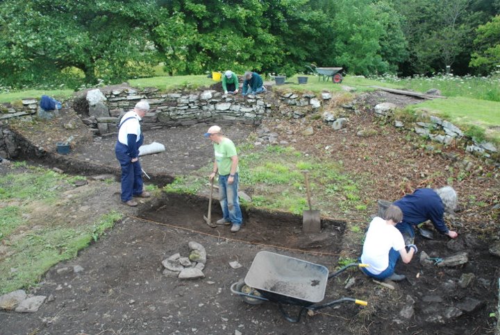
Thrumster Mains submitted by Andy B : Overview of the Thrumster Broch community excavation Photo copyright AOC Archaeology (Vote or comment on this photo)

Thrumster Mains
Thrumster Mains submitted by SolarMegalith : Emptied intra-mural gallery on NW arc of the broch (photo taken on 21st of July 2011). (Vote or comment on this photo)

Thrumster Mains
Thrumster Mains submitted by SolarMegalith : Newly unearthed entrance to the broch - view from the west (photo taken on 11th of July 2011).

Thrumster Mains
Thrumster Mains submitted by SolarMegalith : Partly uncovered intra-mural gallery with blocked entrance - probably it has been blocked in later period (photo taken on 11th of July 2011).

Thrumster Mains
Thrumster Mains submitted by SolarMegalith : Partly uncovered distontinuos gallery in Thrumster Mains broch (photo taken on 9th of July 2011).

Thrumster Mains
Thrumster Mains submitted by SolarMegalith : Thrumster Mains broch seen from the east - Trench 6 in the foreground has been opened in search for remains of possible outbuildings (photo taken on 5th of July 2011).

Thrumster Mains
Thrumster Mains submitted by SolarMegalith : Uncovered (partly by me) internal wallface, top part of which is a Victorian repair (photo taken on 5th of June 2011).

Thrumster Mains
Thrumster Mains submitted by SolarMegalith : Structure of broch walls uncovered in southern part of the broch - later the guard cell seemed to be rather part of a discontinuous gallery (photo taken on 5th July 2011).

Thrumster Mains
Thrumster Mains submitted by Andy B : Leonie and Cezary (SolarMegalith) excavate the primary entrance area at the Thrumster Broch community excavation Photo copyright AOC Archaeology

Thrumster Mains
Thrumster Mains submitted by Andy B : SolarMegalith wields a spade as he gets stuck in at the Thrumster Broch community excavation Photo copyright AOC Archaeolog

Thrumster Mains
Thrumster Mains submitted by Andy B : Thrumster Or Old Garden Broch Picture - Bill Fernie, Caithness Heritage Trust

Thrumster Mains
Thrumster Mains submitted by SolarMegalith : Southern part of the broch in last days of the excavations - the gallery/guard cell (?) has been backfilled and covered with turf (photo taken on 22nd of July 2011).

Thrumster Mains
Thrumster Mains submitted by SolarMegalith : Judging on size of the stones and their closeness to the wall this collapse in eastern part of the broch is probably from 19th century repair (photo taken on 7th of July 2011).

Do not use the above information on other web sites or publications without permission of the contributor.
Click here to see more info for this site

Nearby sites

Click here to view sites on an interactive OS map

Key: Red: member's photo, Blue: 3rd party photo, Yellow: other image, Green: no photo - please go there and take one, Grey: site destroyed

Download sites to:
KML (Google Earth)
GPX (GPS waypoints)
CSV (Garmin/Navman)
CSV (Excel)

To unlock full downloads you need to sign up as a Contributory Member. Otherwise downloads are limited to 50 sites.


Turn off the page maps and other distractions

Nearby sites listing. In the following links * = Image available
 704m ESE 117° Gansclet Standing Stone* Standing Stone (Menhir) (ND33824473)
 774m SE 145° Gansclet Broch Broch or Nuraghe (ND3362744415)
 1.0km NE 39° Thrumster Little Broch* Broch or Nuraghe (ND33844583)
 1.6km S 191° Borrowston Broch* Broch or Nuraghe (ND3288143536)
 1.8km SSW 208° Brounaban* Broch or Nuraghe (ND3231243478)
 2.2km WSW 241° Battle Moss Stone Rows* Multiple Stone Rows / Avenue (ND3128644027)
 2.2km WSW 245° Loch of Yarrows Crannog* Crannog (ND3114944161)
 2.3km SW 222° McCole's Castle* Chambered Cairn (ND3161243364)
 2.4km N 356° Cairnquoy* Broch or Nuraghe (ND33094743)
 2.5km SW 218° Whiteleen Standing Stones* Standing Stones (ND3163743111)
 2.5km SW 217° Whiteleen Cairn* Cairn (ND3165743081)
 2.5km SW 226° Battle Moss Cairns* Cairn (ND31374333)
 2.6km NNW 340° Tannach Mains* Broch or Nuraghe (ND32364748)
 2.8km SW 235° South Yarrows Broch* Broch or Nuraghe (ND3083043492)
 2.8km NE 41° Hempriggs Broch* Broch or Nuraghe (ND35114717)
 2.9km SW 229° South Yarrows round house* Ancient Village or Settlement (ND30964320)
 3.1km WSW 238° South Yarrows Chambered Cairn* Chambered Cairn (ND3049343462)
 3.3km SW 234° South Yarrows Long Cairn* Chambered Cairn (ND3048343193)
 3.4km SSW 205° Watenan East* Stone Row / Alignment (ND31724204)
 3.4km S 187° Heatherquoy Broch or Nuraghe (ND3271341714)
 3.4km SSW 212° Watenan West* Stone Row / Alignment (ND31324218)
 3.4km ENE 59° Hempriggs Chambered Cairn* Chambered Cairn (ND36174680)
 3.6km S 191° Ulbster School Broch or Nuraghe (ND3243141497)
 3.8km SW 222° Warehouse North* Chambered Cairn (ND3056742276)
 3.9km SSW 200° Watenan North Broch Broch or Nuraghe (ND3180441456)
View more nearby sites and additional images

<< The Bulwarks (Breedon on the Hill)

Las Fitas menhir >>

Please add your thoughts on this site

Caithness Archaeology: Aspects of Prehistory

Caithness Archaeology: Aspects of Prehistory

Sponsors

Auto-Translation (Google)

Translate from English into:

"Thrumster Mains" | Login/Create an Account | 10 News and Comments
  
Go back to top of page    Comments are owned by the poster. We aren't responsible for their content.
Thrumster dig uncovers broch era village by Andy B on Thursday, 12 September 2019
(User Info | Send a Message)
Thrumster dig uncovers broch era village, By David G Scott
Long before the John O'Groats Trail or North Coast 500 route existed there was another path within the county that has just been uncovered after lying centuries under the turf.

It may be very small but the well-laid-out stone path, or passageway, exists within structures that are over 2000 years old and lies on moorland at Swartigill on the Thrumster Estate. The structures being uncovered seem to date from the same era as the Iron Age brochs for which the county is famous and suggest that a village of some complexity existed there for a number of centuries.

A team from the Orkney Research Centre for Archaeology (Orca) worked along with the Yarrows Heritage Trust (YHT) to help uncover one of the most "significant finds in the county since the Victorian era", according to estate owner Islay MacLeod.

Previous seasons of excavation at the site have uncovered a complex of ancient structures which are providing an important window into Iron Age society away from the monumental architecture of the brochs.

Speaking before the dig ended for the season on Sunday, project officer Rick Barton from Orca said: "We have had a lot of help from some fantastic volunteers throughout the dig so far, and the team has been getting bigger every day. The alluvial layers shrouding the archaeology on the site are gradually being removed to reveal some interesting structural features and deposits."

More at
https://www.johnogroat-journal.co.uk/news/thrumster-dig-uncovers-prehistoric-village-182783/
[ Reply to This ]

Re: Thrumster Broch Community Excavation, by hornblower on Saturday, 08 February 2014
(User Info | Send a Message)
Since this was posted, the stairway was uncovered (June 2013) when I was clearing up rabbit diggings
Cezary - tried to email you with a pic, but you have changed your email
Cheers
Islay
[ Reply to This ]

Community Excavation of Thrumster Broch, Caithness by Andy B on Sunday, 28 August 2011
(User Info | Send a Message)
Community Excavation of Thrumster Broch, Caithness
By Charlotte Douglas, Friday 22nd of July

We are assisting the Yarrows Heritage Trust in their excavation of a broch in Caithness. AOC’s John Barber is directing excavations, and myself and Alan Duffy are also on hand this week.

Thrumster Broch lies on Thrumster Estate. It was modified to form an ‘oval garden’ in around 1810 according to estate records. Subsequently its wall was slighted on the south side and a summer house was built in the entrance area of the monument. The broch was previously believed to be solid-walled, but our excavations quickly revealed intra-mural galleries. We have also discovered a previously unknown entranceway that we believe was filled in along with some of the galleries in the north-western area of the broch, in an attempt to stabilise the building when subsidence of the ground began to cause structural problems. We now believe that the entranceway recorded in the area in which the summer house was built was a secondary entrance, replacing the recently discovered entrance.

We arrive on site to start work each day at 9 am. I give volunteers a site induction on their first day on site; after this, they can get stuck in as soon as they arrive each day. Our community projects are very relaxed – people can turn up as and when they like for as long as they like. This means that people can get involved in our projects by fitting their participation around their daily lives. What’s more, participation is completely FREE, which is always a winner.

We have 15 people digging with us today, all of whom have been on site previously. Some of our volunteers are studying archaeology or have done so in the past, but almost three quarters of the project’s participants had never dug an archaeological site before – and here they are digging a two thousand year old monument! Our volunteers range in age from four year olds to 74 year olds, and each person makes a worthwhile contribution to the project.

As we are nearing the end of the project, we are not opening any new trenches but are focussing on those already opened. We are trying not to create any more quandaries, but hope desperately to resolve those we are already investigating! For example, the broch wall has up to five or six construction stages depending on its complexity in the area examined. Where galleries exist, two or three inner wall elements and three outer have been noted. We want to know if all of these structural elements are contemporaneous (built at the same time) or whether they have been added over time, enlarging an original structure.

I help get the volunteers started for the day, making sure everyone has the right tools and knows what they are doing. Some volunteers are trowelling; others are drawing plans or sections; beginning to backfill; using the dumpy level and taking soil samples. While digging, volunteers have a plastic tray to hand, into which they place all bulk finds (animal bone, small pieces of pottery, modern finds). Small finds (large pieces of pottery or rim sherds, worked bone, worked stone objects and so on) are bagged up straight away, their details recorded in the register and their exact locations plotted.

I have been surveying the site using a total station, an electronic device that records the exact location in three dimensions of any given point. It is used to map and create 3D plans of a site, and to record the location of finds and so on. On a stone-built site like a broch, this means recording the location of a lot of stones! Site photographs are overlaid with the data gathered with the total station to create 3D maps.

We stop for a tea break at about 10.30am and then everyone cracks on. I ask Jonie to help me take some levels using the dumpy level; although we have a total station, we teach the volunteers to use the dumpy level as many archaeological societies use them regularly, and we want to teach people new skill

Read the rest of this post...
[ Reply to This ]

Re: Thrumster Broch Community Excavation, Post Excavation Talk, Saturday 23rd July, by MikeAitch on Thursday, 14 July 2011
(User Info | Send a Message)
BBC News article Re dig.
[ Reply to This ]

Thrumster Broch Community Excavation, Post Excavation Talk, Saturday 23rd July, by Andy B on Wednesday, 13 July 2011
(User Info | Send a Message)
Saturday 23rd July, 7.30pm, Thrumster Village Hall

Thrumster Broch Community Excavation: what did we find?
Post-excavation analysis: what happens next?
Results & interpretation

http://www.aocarchaeology.com/thrumster/events
[ Reply to This ]

Thrumster broch dig reaches the threshold stone of the 2500 year old entrance by Andy B on Wednesday, 13 July 2011
(User Info | Send a Message)
July 5th: A huge amount has been achieved, all thanks to our hard-working volunteers. We have been joined by Cezary (The Portal's own 'SolarMegalith'), an archaeology student at Reading University, and Florence, an American tourist.

The results of work today challenge Euan MacKie’s suggestion in "Roundhouses, Brochs and Wheelhouses of Atlantic Scotland" that Thrumster Broch is probably solid based. Excavations on the east side of the entrance have revealed the shattered and remodelled walls of the broch, and indicate the existed of voided space at it’s centre. It is not impossible that this is a fragment of a guard cell or a chamber behind a guard cell; further excavation is required to fully understand this feature.

Mon 11th: On site, work by Leonie and Cezary focussed on going down in the primary entrance area, which has not yet reached the old ground surface but which is not far from it. Charlotte continued to clear the gallery space as we get close to excavating the floor deposits.

Tues 12th: A day of new experiences. Charlotte excavated her way down the intra-mural gallery until she was able to step onto the threshold stone of the chamber entrance, which we are pretty sure no one has stepped on in 2000 years.

The inner face of the broch wall between the newly opened west entrance of the Trench 9 excavation has clearly slumped into the subsoil. Today Andy and Cezary took out a wide strip of garden soil abutting the wall to further reveal the pre-broch archaeology into which the wall has slumped in this area. It is tempting to speculate that this slumping led to the abandonment of the west entrance and the sealing off of the cell entrance to Trench 9’s gallery, but a number of difficulties remain with this pleasing interpretation.

Daily updates continue at the Thrumster broch dig diary:

http://www.aocarchaeology.com/thrumster/dig-diary
[ Reply to This ]

Thrumster Broch Community Excavations, 4th to 24th July 2011 by Andy B on Saturday, 18 June 2011
(User Info | Send a Message)
Yarrows Heritage Trust will be running three weeks of excavations at Thrumster Broch, with the expert guidance of archaeologists from AOC Archaeology Group, and as part of the Council for British Archaeology’s Festival of British Archaeology 2011.

Located on a prominent spur of land close to the nationally important archaeological landscape of Yarrows, Thrumster Broch is one of many sites in Caithness to have been excavated in the 19th century, although no accurate or detailed records survive. The interior of the roundhouse was emptied of rubble over 200 years ago, and a summer house built in the area of the broch entrance.

Despite these relatively recent investigations, we can be fairly certain of finding surviving Iron Age archaeology. Although antiquarian excavations were rarely recorded to modern standards, excavations by the National Museums of Scotland at Nybster Broch have demonstrated that in-situ structures, deposits and artefacts can often be well preserved, even after antiquarian digging.

Alexander Rhind and Thrumster
19th century lawyer, Egyptologist and antiquarian Alexander Henry Rhind (1833-63) lived at Thrumster Mains. Rhind can correctly be thought of as one of the forefathers of modern archaeology; he was a brilliant scholar, known for his systematic work and comprehensive knowledge of prehistory. His contribution to the study of British prehistory was enormous for his time, and he excavated several chambered cairns in Caithness. Rhind is remembered by the Society of Antiquaries of Scotland in the Rhind Lecture Series, a prestigious annual lecture series given by invited scholars in Edinburgh.

Come along and take part – excavations will be taking place during the first three weeks of July. To keep up to date with excavation days and public events, and to read the dig diary, go to http://www.aocarchaeology.com/thrumster/

Source:
http://www.caithnessarchaeology.org.uk/summer.html

[ Reply to This ]

Thrumster Broch by Andy B on Saturday, 18 June 2011
(User Info | Send a Message)
More images and information here:
http://www.caithness.org/atoz/brochs/thrumsterhousebroch/index.htm
[ Reply to This ]

Thrumster Broch Community Excavation, by Andy B on Saturday, 18 June 2011
(User Info | Send a Message)
Thrumster Broch Community Excavation

Mon 4–Sun 24 July 09.00–17.00

Participate in an archaeological dig is summer–learn something new about the Iron Age, learn new skills, make new friends, have fun!

In the summer of 2011, AOC Archaeology Group will be working with the Yarrows Heritage Trust on excavations at Thrumster Broch, Caithness. Volunteers of all ages are invited to come and help us learn more about this fascinating site over a 3 week period. Participation is free and no previous experience is required.

Thrumster Broch is one of many sites in Caithness to have been excavated in the 19th Century, although no accurate or detailed records survive. The interior of the roundhouse was emptied of rubble over 200 years ago, and a summer house built in the area of the broch entrance.

The 2011 excavations have three main research objectives:

I. What remains of in-situ archaeological deposits in the broch itself?
II. Did the antiquarian investigation destroy the entrance to the broch or do vestiges remain?
III. What features, buildings or deposits survive around the broch?
It is hoped that the answers to these questions will become evident through the YHT excavations and the subsequent post-excavation analysis.

This exciting community archaeology project has been made possible through funding from LEADER, The Heritage Lottery Fund, Highland Council and Scottish Natural Heritage.
Free! Please book.

Location: Thrumster Mains, Thrumster.

Org: Yarrows Heritage Trust
Name: Paul Humphreys
Tel: Paul: 01847 851 275 / Islay: 01955 651 387
Email: p.humphreys@btinternet.com
Web: http://www.aocarchaeology.com/thrumster/

Part of the Festival of British Archaeology 2011

[ Reply to This ]

Your Name: Anonymous [ Register Now ]
Subject:


Add your comment or contribution to this page. Spam or offensive posts are deleted immediately, don't even bother

<<< What is five plus one as a number? (Please type the answer to this question in the little box on the left)
You can also embed videos and other things. For Youtube please copy and paste the 'embed code'.
For Google Street View please include Street View in the text.
Create a web link like this: <a href="https://www.megalithic.co.uk">This is a link</a>  

Allowed HTML is:
<p> <b> <i> <a> <img> <em> <br> <strong> <blockquote> <tt> <li> <ol> <ul> <object> <param> <embed> <iframe>

We would like to know more about this location. Please feel free to add a brief description and any relevant information in your own language.
Wir möchten mehr über diese Stätte erfahren. Bitte zögern Sie nicht, eine kurze Beschreibung und relevante Informationen in Deutsch hinzuzufügen.
Nous aimerions en savoir encore un peu sur les lieux. S'il vous plaît n'hesitez pas à ajouter une courte description et tous les renseignements pertinents dans votre propre langue.
Quisieramos informarnos un poco más de las lugares. No dude en añadir una breve descripción y otros datos relevantes en su propio idioma.