 with our Megalithic Portal iPhone app")


<< Our Photo Pages >> Knowe of Burrian (Garth Farm) - Broch or Nuraghe in Scotland in Orkney
Submitted by howar on Tuesday, 07 February 2017 Page Views: 2031
Iron Age and Later PrehistorySite Name: Knowe of Burrian (Garth Farm) Alternative Name: Garth FarmCountry: Scotland County: Orkney Type: Broch or Nuraghe
Nearest Town: Dounby
Map Ref: HY30821680
Latitude: 59.032604N Longitude: 3.207013W
Condition:
| 5 | Perfect |
| 4 | Almost Perfect |
| 3 | Reasonable but with some damage |
| 2 | Ruined but still recognisable as an ancient site |
| 1 | Pretty much destroyed, possibly visible as crop marks |
| 0 | No data. |
| -1 | Completely destroyed |
| 5 | Superb |
| 4 | Good |
| 3 | Ordinary |
| 2 | Not Good |
| 1 | Awful |
| 0 | No data. |
| 5 | Can be driven to, probably with disabled access |
| 4 | Short walk on a footpath |
| 3 | Requiring a bit more of a walk |
| 2 | A long walk |
| 1 | In the middle of nowhere, a nightmare to find |
| 0 | No data. |
| 5 | co-ordinates taken by GPS or official recorded co-ordinates |
| 4 | co-ordinates scaled from a detailed map |
| 3 | co-ordinates scaled from a bad map |
| 2 | co-ordinates of the nearest village |
| 1 | co-ordinates of the nearest town |
| 0 | no data |
Internal Links:
External Links:
 (PID:162122)")
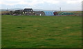
North of Harray Community Hall is the Netherbrough Road. Just past Yeldavale the knowe stands out boldly in the far corner of a field, at this time swamped by bright vegetation. If only I hadn't already been walking for miles I would have paid a visit. It sits on marshy ground thought to have been a lochan. Less than a kilometre further down is another broch, the Knowe of Gullow. I went as far as the turn for Ballarat House, and in the field opposite Gullow is what looked like a banked feature which looks equally Iron Age but must be modern as it is not noted anywhere.
The Knowe of Burrian (a.k.a. Garth Farm), NMRS record no. HY31NW 2, was once 60' in diameter and 17 high. After several failed digs by other folk Robert Flett of Garth made a go of excavating it in 1936, when a trench found distinct layers of 'hearth-materials' - charcoal, pot-boilers, animal bones, etc - then almost at the other side a slight turn revealed an interior chamber floor. As well as the Pictish Symbol Stone he found some burnt wood, stone tools and ashes. And then came the subterranean.
A berm separates south and west sides of broch remains 1.2m high on the flattened top of a steep natural hillock. On the east side are three courses of outer wall face and possible traces of the inner wall face, from which it is estimated that its external diameter is ~18.3m and internal 8.5m. Of two excavations in the centre of the mound the more westerly is the now covered location of an underground chamber. From a vertical entrance approx. 2'6" square eleven steps led steeply down 12' to a 10'x5' flat-roofed figure-of-8 corbelled structure compared to the Gurness well, though the site was called an earth-house rather than a broch at the time.
You may be viewing yesterday's version of this page. To see the most up to date information please register for a free account.
 (PID:162123)")
Do not use the above information on other web sites or publications without permission of the contributor.
Nearby Images from Geograph Britain and Ireland:
©2008(licence)
©2008(licence)
©2008(licence)
©2008(licence)
©2008(licence)
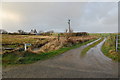
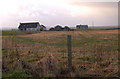
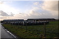
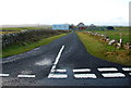
The above images may not be of the site on this page, they are loaded from Geograph.
Please Submit an Image of this site or go out and take one for us!
Click here to see more info for this site
Nearby sites
Key: Red: member's photo, Blue: 3rd party photo, Yellow: other image, Green: no photo - please go there and take one, Grey: site destroyed
Download sites to:
KML (Google Earth)
GPX (GPS waypoints)
CSV (Garmin/Navman)
CSV (Excel)
To unlock full downloads you need to sign up as a Contributory Member. Otherwise downloads are limited to 50 sites.
Turn off the page maps and other distractions
Nearby sites listing. In the following links * = Image available
409m SE 136° Maesquoy* Standing Stones (HY311165)
513m SSW 192° Knowe of Gullow* Broch or Nuraghe (HY307163)
1.0km ENE 72° Caperhouse* Standing Stones (HY318171)
1.2km SE 138° Staney Hill* Chambered Tomb (HY316159)
1.2km NNE 25° Overbrough* Broch or Nuraghe (HY31361790)
1.6km SE 144° Feolquoy* Round Barrow(s) (HY31741551)
1.6km ENE 67° Nettletar* Broch or Nuraghe (HY32321741)
1.7km SE 134° Staney stone* Standing Stone (Menhir) (HY320156)
1.8km SE 134° Venus of the Whins* Round Barrow(s) (HY321155)
1.9km ESE 107° Appiehouse* Standing Stone (Menhir) (HY32621620)
1.9km NW 322° Burrian (Russland)* Broch or Nuraghe (HY29641835)
2.0km SSE 150° Langskaill Mound* Artificial Mound (HY31811505)
2.1km N 3° Uvigar* Artificial Mound (HY30951888)
2.1km ESE 113° Woodwyn* Cairn (HY32781594)
2.3km N 354° Foldarol's Hole* Artificial Mound (HY30631909)
2.4km N 354° Knowe of Browsky* Artificial Mound (HY306192)
2.5km NNE 22° Howen Broch Broch or Nuraghe (HY318191)
2.6km S 175° Campston (Grimeston)* Broch or Nuraghe (HY310142)
2.6km S 175° Grimston Broch* Broch or Nuraghe (HY310142)
2.7km N 349° Laxhowe* Artificial Mound (HY30361943)
2.7km ESE 121° Dale Souterrain* Artificial Mound (HY33111538)
2.9km SSE 166° Vola* Round Barrow(s) (HY31471395)
3.0km NNE 30° Burrian (Corrigall)* Broch or Nuraghe (HY32351937)
3.1km NNE 14° Nisthouse Barrow Cemetery (HY31631983)
3.2km N 359° North Bigging* Broch or Nuraghe (HY3082420003)
View more nearby sites and additional images


 We would like to know more about this location. Please feel free to add a brief description and any relevant information in your own language.
 Wir möchten mehr über diese Stätte erfahren. Bitte zögern Sie nicht, eine kurze Beschreibung und relevante Informationen in Deutsch hinzuzufügen.
 Nous aimerions en savoir encore un peu sur les lieux. S'il vous plaît n'hesitez pas à ajouter une courte description et tous les renseignements pertinents dans votre propre langue.
 Quisieramos informarnos un poco más de las lugares. No dude en añadir una breve descripción y otros datos relevantes en su propio idioma.