<< Our Photo Pages >> Ness of Brodgar - Ancient Village or Settlement in Scotland in Orkney
Submitted by Andy B on Thursday, 24 October 2024 Page Views: 97993
Neolithic and Bronze AgeSite Name: Ness of BrodgarCountry: Scotland County: Orkney Type: Ancient Village or Settlement
Nearest Village: Stromness
Map Ref: HY3024312941
Latitude: 58.997862N Longitude: 3.21584W
Condition:
| 5 | Perfect |
| 4 | Almost Perfect |
| 3 | Reasonable but with some damage |
| 2 | Ruined but still recognisable as an ancient site |
| 1 | Pretty much destroyed, possibly visible as crop marks |
| 0 | No data. |
| -1 | Completely destroyed |
| 5 | Superb |
| 4 | Good |
| 3 | Ordinary |
| 2 | Not Good |
| 1 | Awful |
| 0 | No data. |
| 5 | Can be driven to, probably with disabled access |
| 4 | Short walk on a footpath |
| 3 | Requiring a bit more of a walk |
| 2 | A long walk |
| 1 | In the middle of nowhere, a nightmare to find |
| 0 | No data. |
| 5 | co-ordinates taken by GPS or official recorded co-ordinates |
| 4 | co-ordinates scaled from a detailed map |
| 3 | co-ordinates scaled from a bad map |
| 2 | co-ordinates of the nearest village |
| 1 | co-ordinates of the nearest town |
| 0 | no data |
Internal Links:
External Links:
I have visited· I would like to visit
LittleEnki de1bert0 gailw X-Ice eirrac5 whese001 jain Fizzy would like to visit
wildtalents visited on 15th Jul 2015 - their rating: Cond: 3 Amb: 4 Access: 5 I visited while the annual dig season was in full swing. Difficult to interpret what you're seeing (and much more excavation has been made in the years since, 2024 being the final year of excavation). This isthmus of land is packed with so much history but don't overlook the Ness if you are nearby.
Andy B visited on 2nd Aug 2013 OK this site wasn't actually in the Ancient History of Britain programme but I wanted a link to all our sites in Orkney as Neil visited to look at the Orkney vole.
mgts24 visited on 1st Aug 2013 - their rating: Cond: 3 Amb: 5 Access: 5 I am working there as an archaeology student.
jeffrep visited on 15th Aug 2007 - their rating: Cond: 2 Amb: 4 Access: 4
rrmoser lizh have visited here
Average ratings for this site from all visit loggers: Condition: 2.67 Ambience: 4.33 Access: 4.67
")
In 2003 a large notched stone was ploughed up and a rescue excavation was undertaken, under the Human Remains Call-Off Contract, as the stone was thought to be from a cist. The trench revealed part of a large structure similar to Structure 2 at nearby Barnhouse Neolithic Village. This finding initiated a resistivity survey to try to define the extent of the built archaeology and complement the initial gradiometer survey.
See Orkneyjar.com for a comprehensive up to date listing of finds and theories including the upcoming excavations on the Neolithic site on Ness of Brodgar, in Stenness. The dig usually runs during July and August.
Visit their Official Web Site for more information or read their earlier dig diaries at http://www.orkneyjar.com/archaeology/nessofbrodgar/ (archive link)
Note: Nick Card, Anne Mitchell and Mark Edmonds In Conversation on the Ness of Brodgar for an hour on BBC Radio Orkney - the link to listen is our page
You may be viewing yesterday's version of this page. To see the most up to date information please register for a free account.
")
")
")
")
")
")
")
")
")
")
")
")
")
")
")
")
")
")
")
")
")
")
")
")
These are just the first 25 photos of Ness of Brodgar. If you log in with a free user account you will be able to see our entire collection.
Do not use the above information on other web sites or publications without permission of the contributor.
Click here to see more info for this site
Nearby sites
Key: Red: member's photo, Blue: 3rd party photo, Yellow: other image, Green: no photo - please go there and take one, Grey: site destroyed
Download sites to:
KML (Google Earth)
GPX (GPS waypoints)
CSV (Garmin/Navman)
CSV (Excel)
To unlock full downloads you need to sign up as a Contributory Member. Otherwise downloads are limited to 50 sites.
Turn off the page maps and other distractions
Nearby sites listing. In the following links * = Image available
59m SW 225° Brodgar Farm Chambered Tomb Chambered Tomb (HY302129)
152m SSE 157° Brodgar Farm Standing Stones* Standing Stones (HY303128)
210m SE 131° Lochview Mound* Cairn (HY304128)
429m SE 133° Watch Stone (Orkney)* Standing Stone (Menhir) (HY30551264)
569m ESE 114° Barnhouse Settlement* Ancient Village or Settlement (HY30761270)
598m SE 134° Stenness* Stone Circle (HY30671252)
714m WNW 301° Comet Stone (Orkney)* Standing Stone (Menhir) (HY2963413318)
782m NW 304° Fresh Knowe* Long Barrow (HY29601339)
809m W 272° Fairy Well (Stenness)* Holy Well or Sacred Spring (HY2943212982)
890m WNW 296° Ring of Brodgar* Stone Circle (HY29451335)
897m WNW 291° South Knowe* Artificial Mound (HY29411328)
909m W 269° Possible large stone circle in Loch of Stenness Stone Circle (HY2933112934)
927m NW 306° Plumcake Mound* Round Barrow(s) (HY295135)
1.0km WNW 290° Salt Knowe* Round Barrow(s) (HY293133)
1.3km SE 126° Barnhouse Stone* Standing Stone (Menhir) (HY31271217)
1.3km S 179° Standing Stones Hotel* Chambered Cairn (HY30251165)
1.5km NNE 30° Grimston Broch* Broch or Nuraghe (HY310142)
1.5km NNE 30° Campston (Grimeston)* Broch or Nuraghe (HY310142)
1.5km WNW 302° Wasbister Burnt Mound* Artificial Mound (HY28961378)
1.5km WNW 298° Wasbister Disc Barrow* Round Barrow(s) (HY289137)
1.5km WNW 298° Dyke o'Sean* Ancient Village or Settlement (HY289137)
1.6km E 95° Maes Howe* Chambered Cairn (HY31821277)
1.6km NE 49° Vola* Round Barrow(s) (HY31471395)
1.6km NW 305° Bookan Cairns* Cairn (HY289139)
1.7km NW 309° Bookan Stones* Standing Stones (HY28921406)
View more nearby sites and additional images


 We would like to know more about this location. Please feel free to add a brief description and any relevant information in your own language.
 Wir möchten mehr über diese Stätte erfahren. Bitte zögern Sie nicht, eine kurze Beschreibung und relevante Informationen in Deutsch hinzuzufügen.
 Nous aimerions en savoir encore un peu sur les lieux. S'il vous plaît n'hesitez pas à ajouter une courte description et tous les renseignements pertinents dans votre propre langue.
 Quisieramos informarnos un poco más de las lugares. No dude en añadir una breve descripción y otros datos relevantes en su propio idioma.
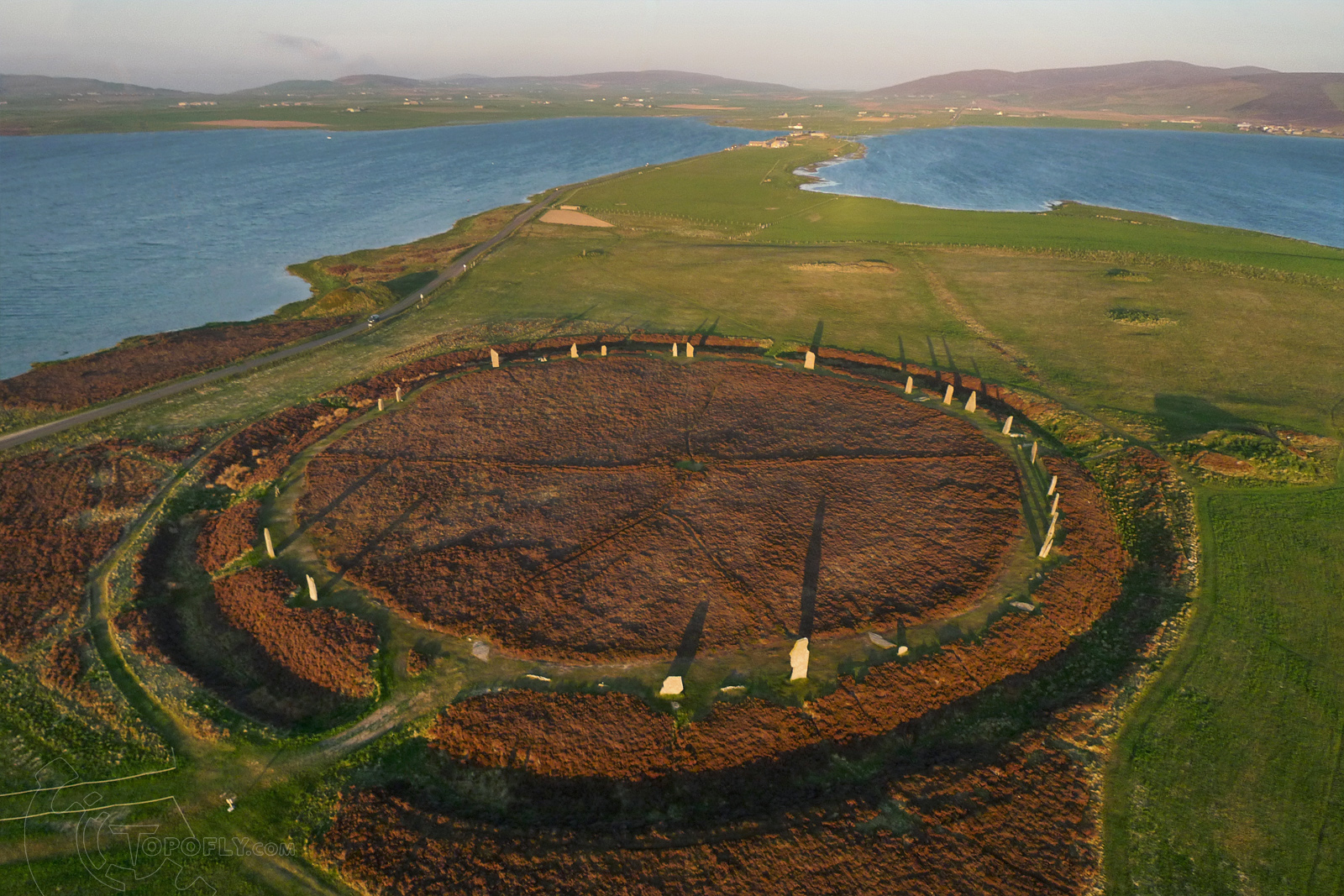