<< Our Photo Pages >> Ring of Brodgar - Stone Circle in Scotland in Orkney
Submitted by Andy B on Saturday, 12 April 2025 Page Views: 57072
Neolithic and Bronze AgeSite Name: Ring of Brodgar Alternative Name: The Ring of BrogarCountry: Scotland County: Orkney Type: Stone Circle
Nearest Town: Stromness Nearest Village: Finstown
Map Ref: HY29451335 Landranger Map Number: 6
Latitude: 59.001404N Longitude: 3.229769W
Condition:
| 5 | Perfect |
| 4 | Almost Perfect |
| 3 | Reasonable but with some damage |
| 2 | Ruined but still recognisable as an ancient site |
| 1 | Pretty much destroyed, possibly visible as crop marks |
| 0 | No data. |
| -1 | Completely destroyed |
| 5 | Superb |
| 4 | Good |
| 3 | Ordinary |
| 2 | Not Good |
| 1 | Awful |
| 0 | No data. |
| 5 | Can be driven to, probably with disabled access |
| 4 | Short walk on a footpath |
| 3 | Requiring a bit more of a walk |
| 2 | A long walk |
| 1 | In the middle of nowhere, a nightmare to find |
| 0 | No data. |
| 5 | co-ordinates taken by GPS or official recorded co-ordinates |
| 4 | co-ordinates scaled from a detailed map |
| 3 | co-ordinates scaled from a bad map |
| 2 | co-ordinates of the nearest village |
| 1 | co-ordinates of the nearest town |
| 0 | no data |
Internal Links:
External Links:
I have visited· I would like to visit
SteveC steph sharipdx lichen Judy6 coin jimstone whese001 jain morgan20 trylondm would like to visit
rachelh visited on 14th Apr 2025 - their rating: Cond: 5 Amb: 5 Access: 5
drolaf visited on 14th Jun 2022 - their rating: Cond: 3 Amb: 5 Access: 4
brianlavelle visited on 4th Apr 2022 - their rating: Cond: 4 Amb: 5 Access: 5
DocRock visited on 2nd Oct 2019 - their rating: Amb: 4 Access: 5
hidebasket visited on 1st Oct 2019 - their rating: Cond: 5 Amb: 5 Access: 5
Catrinm visited on 27th Aug 2019 - their rating: Cond: 3 Amb: 5 Access: 4 Exceptional site - better to go in evening without the crowds
sba_dk visited on 19th Jul 2018 - their rating: Cond: 5 Amb: 5 Access: 5
bishop_pam visited on 22nd Apr 2018 - their rating: Cond: 5 Amb: 5 Access: 5 New turf had been laid since our last visit, so we were able to walk close to the stones and to touch them.
bishop_pam visited on 18th Apr 2018 - their rating: Cond: 5 Amb: 5 Access: 5 Access to the stones was restricted as the path close to them had been heavily worn, so we had to use a path slightly further away.
RockHugger visited on 23rd Sep 2016 - their rating: Cond: 5 Amb: 5 Access: 4
RedKite1985 saw from a distance on 14th Sep 2016 - their rating: Cond: 5 Amb: 5 Access: 4
wildtalents visited on 13th Jul 2015 - their rating: Cond: 4 Amb: 5 Access: 4 As I was staying nearby I took the opportunity to visit this magnificent monument several times, at different times of day. The first visit was the best: the sun was beginning to set (but it stays low on the horizon a long time at this time of year on Orkney) and the stones cast the most almighty shadows. How the henge ditch was dug in this very solid rocky landscape I can only imagine. The people who built the monuments at Stenness definitely made no half measures.
SandyG visited on 2nd Jun 2015 - their rating: Cond: 5 Amb: 5 Access: 5 A trully impressive site.
NickyD visited on 1st May 2015 - their rating: Cond: 4 Amb: 5 Access: 5 My most favourite site. Managed to visit a couple of times a day and had the place to ourselves for most of them. It truly is the most magical place. We experimented with the sound/echo effects here and at the Stones of Stenness and the results were fascinating.
Estrela visited on 28th May 2014 - their rating: Cond: 3 Amb: 5 Access: 4 We were lucky enough to arrive at the Ring of Brodgar to have our picnic lunch 15 minutes before a scheduled free walk was to begin with one of the two rangers who do walks around both the megalithic sites and the wildlife havens in Orkney mainland.
The Ring of Brodgar is the most impressive site, even with stones fallen or missing. Its purpose is variously supposed to have been as a temple of the sun (with the Stones of Stenness as the temple of the moon) or as a gathering place showing the different clans that contributed each their own stone brought from their area of the islands. In the Neolithic the 60+ islands were mainly joined as two main islands, later separated and partially submerged by rising sea levels. The freshwater and seawater lochs which frame these megalithic structures seem to have had particular significance all over Europe, where water and swamp land were held to be special places.
The Ring is an enormous ring composed of stones from differing areas of Orkney perhaps aligned to their points of origin, as the stones are not perfectly upright, and tend to have sloped tops, perhaps acting as signposts, perhaps angled to reflect the angles of natural and constructed hills.
freedomandpeace visited on 2nd May 2014 - their rating: Cond: 4 Amb: 5 Access: 5 I love this stone circle! It is massive.
TwinFlamesKiss visited on 1st Apr 2014 - their rating: Cond: 5 Amb: 5 Access: 4 Easy to find. Open and exposed to weather. Short walk from car park.
quietsunshine visited on 1st Feb 2014 I was on an Elderhostel trip to Scotland that included a few days in Kirkwall, Orkney. The day started out rainy but by the time we got to Ring of Brodnar it was clear and bright - a lovely experience
Jansold visited on 3rd Jun 2013 - their rating: Cond: 4 Amb: 5
ModernExplorers visited on 6th Mar 2013 - their rating: Cond: 3 Amb: 5 Access: 4 Amzing stone circle - huge circle, huge stones and set in beautiful surroundings
43559959 visited on 27th Oct 2011 - their rating: Cond: 4 Amb: 4 Access: 4
crystalskull84 visited on 13th Aug 2011 - their rating: Cond: 5 Amb: 5 Access: 4 Superb!
megalithicmatt visited on 22nd Jun 2011 - their rating: Cond: 4 Amb: 5 Access: 4 Very busy unfortunately, plus the paths are well worn and detracting. Best to get there on a winter's evening I think.
jeffrep visited on 24th Jun 2010 - their rating: Cond: 4 Amb: 5 Access: 4 First Visited: August 14, 2007.
Andy B visited on 18th Dec 2004 Several shots in Episode Three of BBC's History of Ancient Britain
Richard13 visited on 1st Jul 1999 - their rating: Cond: 5 Amb: 5 Access: 5
ladydi45 visited on 3rd Jun 1998 - their rating: Cond: 3 Access: 3
sirius_b visited on 1st Oct 1987 - their rating: Cond: 5 Amb: 5
Chappers60 visited - their rating: Cond: 5 Amb: 5 Access: 5
Tonnox Orcinus rrmoser Bladup DrewParsons CoppellaiaMatta tyrianterror AngieLake TimPrevett rldixon tom_bullock davidmorgan Runemage MegalithJunkie smparry123 X-Ice X-Ice HaggisAction Andy B Redfun mrcrow Pallando have visited here
Average ratings for this site from all visit loggers: Condition: 4.31 Ambience: 4.92 Access: 4.44

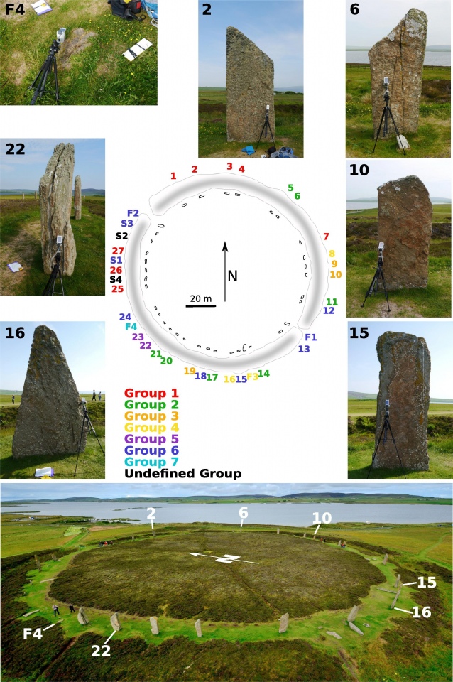
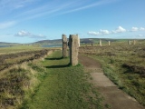
The stone circle is 104 metres in diameter and was originally thought to have comprised of 60 stones, of which only 27 remain standing today. The tallest stones stand at the south and west of the ring.
The surrounding area is full of other standing stones and Bronze Age round barrows, making a significant ritual landscape. Nearby are the Stones of Stenness.
Access: Immediately west of B9055, and well signposted. A Historic Scotland site (state care). Free entry
Historic Environment Scotland on tackling erosion at the Ring of Brodgar, in the comments on our page. Also research into the Brodgar flint point, which was first noted in 1956, lost, and found again in the Hunterian Museum in 2015
Stonehenge Altar Stone Latest: Portable XRF analysis of Stenness and Brodgar stones indicates Altar Stone NOT sourced from Mainland Orkney. Previous results about 'Scottish' (Laurentian) source still apply so the search must continue... New paper by Bevins, Ixer et al. More in the comments on our page
Note: 'Mysteries of Prehistoric Scotland' video series now available to watch on Youtube, details in the comments or click on the top photo
You may be viewing yesterday's version of this page. To see the most up to date information please register for a free account.








These are just the first 25 photos of Ring of Brodgar. If you log in with a free user account you will be able to see our entire collection.
Do not use the above information on other web sites or publications without permission of the contributor.
Click here to see more info for this site
Nearby sites
Key: Red: member's photo, Blue: 3rd party photo, Yellow: other image, Green: no photo - please go there and take one, Grey: site destroyed
Download sites to:
KML (Google Earth)
GPX (GPS waypoints)
CSV (Garmin/Navman)
CSV (Excel)
To unlock full downloads you need to sign up as a Contributory Member. Otherwise downloads are limited to 50 sites.
Turn off the page maps and other distractions
Nearby sites listing. In the following links * = Image available
80m SSW 209° South Knowe* Artificial Mound (HY29411328)
155m ENE 74° Fresh Knowe* Long Barrow (HY29601339)
158m WSW 250° Salt Knowe* Round Barrow(s) (HY293133)
158m NNE 17° Plumcake Mound* Round Barrow(s) (HY295135)
186m E 99° Comet Stone (Orkney)* Standing Stone (Menhir) (HY2963413318)
368m S 182° Fairy Well (Stenness)* Holy Well or Sacred Spring (HY2943212982)
432m SSW 195° Possible large stone circle in Loch of Stenness Stone Circle (HY2933112934)
650m WNW 301° Wasbister Disc Barrow* Round Barrow(s) (HY289137)
650m WNW 301° Dyke o'Sean* Ancient Village or Settlement (HY289137)
650m NW 310° Wasbister Burnt Mound* Artificial Mound (HY28961378)
776m NW 314° Bookan Cairns* Cairn (HY289139)
872m ESE 120° Brodgar Farm Chambered Tomb Chambered Tomb (HY302129)
884m NW 322° Bookan Stones* Standing Stones (HY28921406)
889m NW 313° Wasbister Cairn* Cairn (HY28811397)
890m ESE 116° Ness of Brodgar* Ancient Village or Settlement (HY3024312941)
1.0km ESE 122° Brodgar Farm Standing Stones* Standing Stones (HY303128)
1.1km ESE 119° Lochview Mound* Cairn (HY304128)
1.1km NW 310° Bookan* Chambered Tomb (HY286141)
1.3km NW 317° The Brecks* Cairn (HY286143)
1.3km ESE 122° Watch Stone (Orkney)* Standing Stone (Menhir) (HY30551264)
1.5km ESE 115° Barnhouse Settlement* Ancient Village or Settlement (HY30761270)
1.5km ESE 123° Stenness* Stone Circle (HY30671252)
1.6km NW 310° Skae Frue* Round Barrow(s) (HY28241440)
1.6km NW 314° Ring of Bookan* Henge (HY283145)
1.8km ENE 60° Grimston Broch* Broch or Nuraghe (HY310142)
View more nearby sites and additional images


 We would like to know more about this location. Please feel free to add a brief description and any relevant information in your own language.
 Wir möchten mehr über diese Stätte erfahren. Bitte zögern Sie nicht, eine kurze Beschreibung und relevante Informationen in Deutsch hinzuzufügen.
 Nous aimerions en savoir encore un peu sur les lieux. S'il vous plaît n'hesitez pas à ajouter une courte description et tous les renseignements pertinents dans votre propre langue.
 Quisieramos informarnos un poco más de las lugares. No dude en añadir una breve descripción y otros datos relevantes en su propio idioma.