<< Our Photo Pages >> St Margaret's Well (Edinburgh) - Holy Well or Sacred Spring in Scotland in Midlothian
Submitted by vicky on Monday, 29 March 2004 Page Views: 14687
Springs and Holy WellsSite Name: St Margaret's Well (Edinburgh)Country: Scotland County: Midlothian Type: Holy Well or Sacred Spring
Nearest Town: Edinburgh
Map Ref: NT2713373712 Landranger Map Number: 66
Latitude: 55.950891N Longitude: 3.168436W
Condition:
| 5 | Perfect |
| 4 | Almost Perfect |
| 3 | Reasonable but with some damage |
| 2 | Ruined but still recognisable as an ancient site |
| 1 | Pretty much destroyed, possibly visible as crop marks |
| 0 | No data. |
| -1 | Completely destroyed |
| 5 | Superb |
| 4 | Good |
| 3 | Ordinary |
| 2 | Not Good |
| 1 | Awful |
| 0 | No data. |
| 5 | Can be driven to, probably with disabled access |
| 4 | Short walk on a footpath |
| 3 | Requiring a bit more of a walk |
| 2 | A long walk |
| 1 | In the middle of nowhere, a nightmare to find |
| 0 | No data. |
| 5 | co-ordinates taken by GPS or official recorded co-ordinates |
| 4 | co-ordinates scaled from a detailed map |
| 3 | co-ordinates scaled from a bad map |
| 2 | co-ordinates of the nearest village |
| 1 | co-ordinates of the nearest town |
| 0 | no data |
Internal Links:
External Links:
I have visited· I would like to visit
TimPrevett visited on 23rd Jun 2021 - their rating: Cond: 4 Amb: 4 Access: 5 Nicely presented well, be sure to take a peep through the grill and look at the interior, especially the ceiling
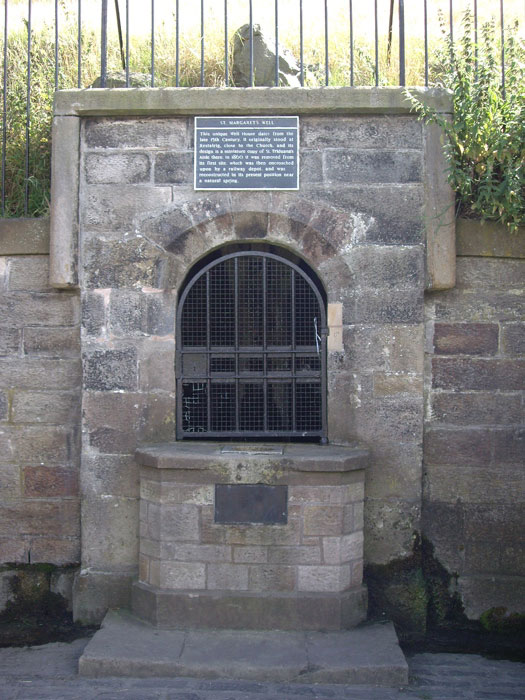
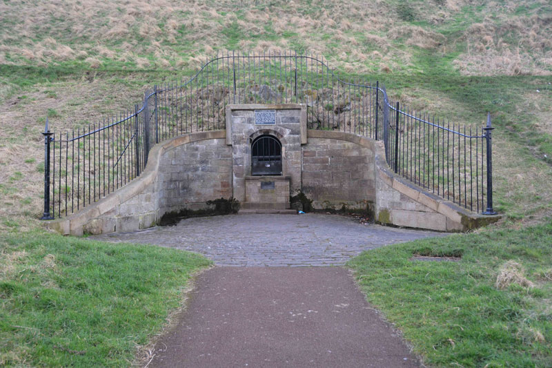
Anne T visited on 20th Feb 2017 - their rating: Cond: 3 Amb: 3 Access: 5 St Margaret's Well, Holyrood, Edinburgh: Located just off Queen’s Drive in Holyrood, near Dynamic Earth, and 400 metres from St. Anthony’s Well, this well house can be seen from the road.
I had to photo-shop out the pile of rubbish that had gathered at the base of the well (disgusting!). There was a good flow of water out of the pipe inside the well house, although it was impossible to get a photograph of this there was a black heavy metal grill covering it.
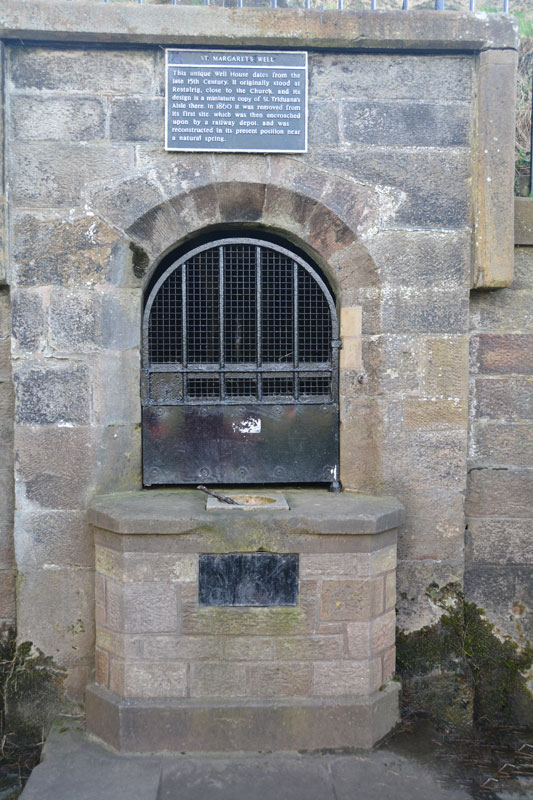
I came across a reference on Pixyledpublications telling me “the spring itself is a holy well, called The Well of the Holy Rood or St. David’s Well and dates from 1198, the well head was re-erected from St. Margaret’s Well at Restalrig ….. legend has it that King David after mass decided to go hunting in the area and was thrown from his horse by a giant stag which then carried the king, stopping at the spring. In thanks for his deliverance, he built the Abbey of Holyrood there …. (the well house) has an internal width of six feet by five feet in height with a central pier with a carved head which is provided with a spout.”
The well house bears a plaque which reads: “This unique Well House dates from the late 15th Century. It originally stood at Restalrig, close to the Church, and its design is a miniature copy of St. Triduana’s Aisle there. In 1860 it was removed from its first site, which was then encroached upon by a railway depot, and was reconstructed in its present position near a natural spring.”
feorag have visited here
Average ratings for this site from all visit loggers: Condition: 3.5 Ambience: 3.5 Access: 5

This holy well is recorded as Canmore ID 52167, extracts from which read: "Queen's Park was the site of a temporary smallpox hospital in 1894 ... In 1852, St Margaret's Well, a holy well (Walker 1883) is described as a spring well, enclosed by an ancient vault over which part of the railway workshops had been built. In 1860, this well-house was rebuilt in its present position. It is a miniature Gothic cell of the 15th century, evidently based on, and therefore later than, St Triduana's Well at Restalrig ... St Margaret's well-house is set into the natural hillslope immediately below the modern track that provides vehicular access to Hunter's Bog. It is is fronted by a curvilinear stone facade surmounted by iron railings."
You may be viewing yesterday's version of this page. To see the most up to date information please register for a free account.


Do not use the above information on other web sites or publications without permission of the contributor.
Click here to see more info for this site
Nearby sites
Key: Red: member's photo, Blue: 3rd party photo, Yellow: other image, Green: no photo - please go there and take one, Grey: site destroyed
Download sites to:
KML (Google Earth)
GPX (GPS waypoints)
CSV (Garmin/Navman)
CSV (Excel)
To unlock full downloads you need to sign up as a Contributory Member. Otherwise downloads are limited to 50 sites.
Turn off the page maps and other distractions
Nearby sites listing. In the following links * = Image available
392m E 100° St Anthony's Well (Edinburgh)* Holy Well or Sacred Spring (NT27527364)
440m WNW 296° Girth Cross (Canongate)* Ancient Cross (NT2673973910)
471m SSW 195° Salisbury Crags* Promontory Fort / Cliff Castle (NT27007326)
666m W 278° Canongate Mercat Cross* Ancient Cross (NT2647273812)
843m W 270° St John's Cross (Canongate)* Ancient Cross (NT2628873733)
1.0km SSW 200° Slidey Stane (Holyrood Park)* Natural Stone / Erratic / Other Natural Feature (NT2676672765)
1.0km SSE 149° Arthur's Seat* Hillfort (NT27647282)
1.2km ESE 117° Dunsapie Crag* Hillfort (NT28177316)
1.3km SSE 164° Samson's Ribs* Promontory Fort / Cliff Castle (NT27457250)
1.3km ESE 116° Holyrood Park Stone (Edinburgh) Natural Stone / Erratic / Other Natural Feature (NT28267313)
1.4km WSW 252° National Museum of Scotland (Early Christian Stones)* Ancient Cross (NT2583273324)
1.4km SW 235° Edinburgh Runestone* Carving (NT2598972937)
1.4km ENE 57° St Triduana's Wellhouse* Holy Well or Sacred Spring (NT2833274468)
1.4km WSW 252° National Museum of Scotland* Museum (NT2574873290)
1.5km WSW 253° National Museum of Scotland (Pictish Stones)* Museum (NT2572173302)
1.5km SE 133° Delf Well* Holy Well or Sacred Spring (NT282727)
1.8km WSW 257° Grassmarket modern menhir* Standing Stone (Menhir) (NT25337333)
1.8km W 262° Stone of Scone* Marker Stone (NT253735)
1.9km WSW 256° The Portsburgh Stone* Natural Stone / Erratic / Other Natural Feature (NT25287327)
2.0km W 266° St Margaret's Well (Edinburgh Castle)* Holy Well or Sacred Spring (NT2508273613)
2.1km SSW 201° Penny Well (Edinburgh)* Holy Well or Sacred Spring (NT26367177)
2.7km W 280° St Bernard's Well* Holy Well or Sacred Spring (NT2445174247)
2.7km W 277° St George's Well (Edinburgh)* Holy Well or Sacred Spring (NT2440174070)
3.0km S 173° Cat Stane (Inch)* Standing Stone (Menhir) (NT27457068)
3.4km SW 230° The Bore Stone* Marker Stone (NT2450871568)
View more nearby sites and additional images


 We would like to know more about this location. Please feel free to add a brief description and any relevant information in your own language.
 Wir möchten mehr über diese Stätte erfahren. Bitte zögern Sie nicht, eine kurze Beschreibung und relevante Informationen in Deutsch hinzuzufügen.
 Nous aimerions en savoir encore un peu sur les lieux. S'il vous plaît n'hesitez pas à ajouter une courte description et tous les renseignements pertinents dans votre propre langue.
 Quisieramos informarnos un poco más de las lugares. No dude en añadir una breve descripción y otros datos relevantes en su propio idioma.