<< Our Photo Pages >> St Triduana's Wellhouse - Holy Well or Sacred Spring in Scotland in Midlothian
Submitted by KiwiBetsy on Wednesday, 30 August 2006 Page Views: 12551
Springs and Holy WellsSite Name: St Triduana's WellhouseCountry: Scotland County: Midlothian Type: Holy Well or Sacred Spring
Nearest Town: Edinburgh
Map Ref: NT2833274468
Latitude: 55.957863N Longitude: 3.149441W
Condition:
| 5 | Perfect |
| 4 | Almost Perfect |
| 3 | Reasonable but with some damage |
| 2 | Ruined but still recognisable as an ancient site |
| 1 | Pretty much destroyed, possibly visible as crop marks |
| 0 | No data. |
| -1 | Completely destroyed |
| 5 | Superb |
| 4 | Good |
| 3 | Ordinary |
| 2 | Not Good |
| 1 | Awful |
| 0 | No data. |
| 5 | Can be driven to, probably with disabled access |
| 4 | Short walk on a footpath |
| 3 | Requiring a bit more of a walk |
| 2 | A long walk |
| 1 | In the middle of nowhere, a nightmare to find |
| 0 | No data. |
| 5 | co-ordinates taken by GPS or official recorded co-ordinates |
| 4 | co-ordinates scaled from a detailed map |
| 3 | co-ordinates scaled from a bad map |
| 2 | co-ordinates of the nearest village |
| 1 | co-ordinates of the nearest town |
| 0 | no data |
Internal Links:
External Links:
")
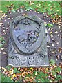
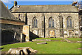
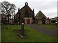
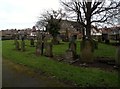
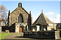
St Triduana’s Wellhouse and Chapel is located next to St Margarets Parish Church off Restalrig Road South in Edinburgh.
For more information see Canmore ID 52104, an extract of which reads: "It was already in existence in 1477. Its design, a two-storeyed vaulted hexagon, 36'6" in external diameter, is unique. The lower chapel, built partly below ground, survives intact; it was restored in 1907-8 after use as a burial vault. The upper chamber, a chapel of unknown dedication, was demolished in 1560. Traditionally, St Triduana, in the 8th century, blinded herself and thereafter retired to Restalrig, where she was buried. Her shrine became a place of pilgrimage for those with diseases of the eye, a practice mentioned as late as the 16th century."
Note: Access must be arranged by contacting St Margarets Church office.
You may be viewing yesterday's version of this page. To see the most up to date information please register for a free account.
")
")
")
")
Do not use the above information on other web sites or publications without permission of the contributor.
Nearby Images from Geograph Britain and Ireland:
©2009(licence)
©2017(licence)
©2013(licence)
©2013(licence)
©2017(licence)
The above images may not be of the site on this page, they are loaded from Geograph.
Please Submit an Image of this site or go out and take one for us!
Click here to see more info for this site
Nearby sites
Key: Red: member's photo, Blue: 3rd party photo, Yellow: other image, Green: no photo - please go there and take one, Grey: site destroyed
Download sites to:
KML (Google Earth)
GPX (GPS waypoints)
CSV (Garmin/Navman)
CSV (Excel)
To unlock full downloads you need to sign up as a Contributory Member. Otherwise downloads are limited to 50 sites.
Turn off the page maps and other distractions
Nearby sites listing. In the following links * = Image available
1.2km SW 223° St Anthony's Well (Edinburgh)* Holy Well or Sacred Spring (NT27527364)
1.3km S 186° Dunsapie Crag* Hillfort (NT28177316)
1.3km S 182° Holyrood Park Stone (Edinburgh) Natural Stone / Erratic / Other Natural Feature (NT28267313)
1.4km WSW 237° St Margaret's Well (Edinburgh)* Holy Well or Sacred Spring (NT2713373712)
1.7km WSW 250° Girth Cross (Canongate)* Ancient Cross (NT2673973910)
1.8km S 183° Delf Well* Holy Well or Sacred Spring (NT282727)
1.8km SSW 202° Arthur's Seat* Hillfort (NT27647282)
1.8km SW 227° Salisbury Crags* Promontory Fort / Cliff Castle (NT27007326)
2.0km WSW 250° Canongate Mercat Cross* Ancient Cross (NT2647273812)
2.2km SSW 203° Samson's Ribs* Promontory Fort / Cliff Castle (NT27457250)
2.2km WSW 249° St John's Cross (Canongate)* Ancient Cross (NT2628873733)
2.3km SW 222° Slidey Stane (Holyrood Park)* Natural Stone / Erratic / Other Natural Feature (NT2676672765)
2.7km WSW 244° National Museum of Scotland (Early Christian Stones)* Ancient Cross (NT2583273324)
2.8km SW 236° Edinburgh Runestone* Carving (NT2598972937)
2.8km WSW 244° National Museum of Scotland* Museum (NT2574873290)
2.9km WSW 245° National Museum of Scotland (Pictish Stones)* Museum (NT2572173302)
3.2km WSW 251° Stone of Scone* Marker Stone (NT253735)
3.2km WSW 248° Grassmarket modern menhir* Standing Stone (Menhir) (NT25337333)
3.3km WSW 248° The Portsburgh Stone* Natural Stone / Erratic / Other Natural Feature (NT25287327)
3.3km SW 215° Penny Well (Edinburgh)* Holy Well or Sacred Spring (NT26367177)
3.4km WSW 254° St Margaret's Well (Edinburgh Castle)* Holy Well or Sacred Spring (NT2508273613)
3.6km SSE 154° Niddrie House* Standing Stone (Menhir) (NT29877125)
3.9km W 266° St Bernard's Well* Holy Well or Sacred Spring (NT2445174247)
3.9km SSW 192° Cat Stane (Inch)* Standing Stone (Menhir) (NT27457068)
3.9km W 263° St George's Well (Edinburgh)* Holy Well or Sacred Spring (NT2440174070)
View more nearby sites and additional images


 We would like to know more about this location. Please feel free to add a brief description and any relevant information in your own language.
 Wir möchten mehr über diese Stätte erfahren. Bitte zögern Sie nicht, eine kurze Beschreibung und relevante Informationen in Deutsch hinzuzufügen.
 Nous aimerions en savoir encore un peu sur les lieux. S'il vous plaît n'hesitez pas à ajouter une courte description et tous les renseignements pertinents dans votre propre langue.
 Quisieramos informarnos un poco más de las lugares. No dude en añadir una breve descripción y otros datos relevantes en su propio idioma.