<< Other Photo Pages >> The Bore Stone - Marker Stone in Scotland in Midlothian
Submitted by Andy B on Sunday, 14 August 2022 Page Views: 959
Date UncertainSite Name: The Bore Stone Alternative Name: Hare StoneCountry: Scotland County: Midlothian Type: Marker Stone
Nearest Town: Edinburgh Nearest Village: Morningside
Map Ref: NT2450871568
Latitude: 55.931227N Longitude: 3.20986W
Condition:
| 5 | Perfect |
| 4 | Almost Perfect |
| 3 | Reasonable but with some damage |
| 2 | Ruined but still recognisable as an ancient site |
| 1 | Pretty much destroyed, possibly visible as crop marks |
| 0 | No data. |
| -1 | Completely destroyed |
| 5 | Superb |
| 4 | Good |
| 3 | Ordinary |
| 2 | Not Good |
| 1 | Awful |
| 0 | No data. |
| 5 | Can be driven to, probably with disabled access |
| 4 | Short walk on a footpath |
| 3 | Requiring a bit more of a walk |
| 2 | A long walk |
| 1 | In the middle of nowhere, a nightmare to find |
| 0 | No data. |
| 5 | co-ordinates taken by GPS or official recorded co-ordinates |
| 4 | co-ordinates scaled from a detailed map |
| 3 | co-ordinates scaled from a bad map |
| 2 | co-ordinates of the nearest village |
| 1 | co-ordinates of the nearest town |
| 0 | no data |
Internal Links:
External Links:
I have visited· I would like to visit
schwagmyre has visited here
")
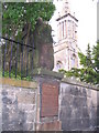
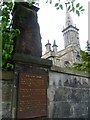
An entry in the Burgh Records for 1586 refers to it as "...the Standand Stane toward Typperlin betuix the lands of Merchonstoun and the [Pow] burne." The 18thC historian William Maitland describes its original position as being on the eastern side of the road "almost opposite to the south-eastern corner of the Park-wall of Tipperlin Lone [now Albert Terrace]", which suggests that it may have been just a village boundary marker. It was placed in its present position by the owner of Greenhill, Sir John Stuart Forbes of Pitsligo, in 1852, doubtless under the strong influence of Walter Scott who was responsible in the first place for establishing the story attached to the stone.
As part of their feudal obligations as tenants of the Crown, the Clerks, as lairds of Penicuik, had to stand on a stone on the 'Burrowmore' and salute the King with three blasts of the horn whenever he went hunting in the area. Mrs Clerk had to come along, too, but could retain her lady-like composure by having to give only one blast. This obligation, the origin of which is lost in the mists of time, was renewed in a Royal charter of 1613, and even confirmed in another charter under Cromwell's rule in 1654. Some scholars have identified the act with the Buckstane near Fairmilehead, but, since that lay beyond the burgh muir, the Hare stane which stood on its edge has the better claim.
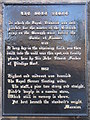
The vintage placard reads: "The Bore Stone, in which the Royal Standard was allegedly pitched for the muster of the Scottish Army on the Burgh Muir before the battle of Flodden 1513."
"It long lay in the adjoining field, was then built into the wall near this spot, and finally placed here by Sir John Stuart Forbes of Pitsligo Bart. 1852."
"Highest and midmost was descried
The Royal Banner floating wide,
The staff, a pine tree strong and straight,
Pitch'd steeply in a massive stone,
Which still in memory is shown,
Yet bent beneath the standard's weight.
Marmion"
It could possibly have been the cover from a prehistoric cist. According to Canmore / HES the cup marks are natural.
Canmore link
You may be viewing yesterday's version of this page. To see the most up to date information please register for a free account.
Do not use the above information on other web sites or publications without permission of the contributor.
Nearby Images from Geograph Britain and Ireland:
©2014(licence)
©2007(licence)
©2010(licence)

©2015(licence)
©2011(licence)
The above images may not be of the site on this page, they are loaded from Geograph.
Please Submit an Image of this site or go out and take one for us!
Click here to see more info for this site
Nearby sites
Key: Red: member's photo, Blue: 3rd party photo, Yellow: other image, Green: no photo - please go there and take one, Grey: site destroyed
Download sites to:
KML (Google Earth)
GPX (GPS waypoints)
CSV (Garmin/Navman)
CSV (Excel)
To unlock full downloads you need to sign up as a Contributory Member. Otherwise downloads are limited to 50 sites.
Turn off the page maps and other distractions
Nearby sites listing. In the following links * = Image available
957m S 179° Hanging Stanes (Braid Road)* Marker Stone (NT24517061)
1.9km E 83° Penny Well (Edinburgh)* Holy Well or Sacred Spring (NT26367177)
1.9km NNE 23° The Portsburgh Stone* Natural Stone / Erratic / Other Natural Feature (NT25287327)
1.9km NNE 24° Grassmarket modern menhir* Standing Stone (Menhir) (NT25337333)
2.0km NE 46° Edinburgh Runestone* Carving (NT2598972937)
2.1km NNE 21° Stone of Scone* Marker Stone (NT253735)
2.1km NE 34° National Museum of Scotland (Pictish Stones)* Museum (NT2572173302)
2.1km NE 35° National Museum of Scotland* Museum (NT2574873290)
2.1km NNE 15° St Margaret's Well (Edinburgh Castle)* Holy Well or Sacred Spring (NT2508273613)
2.2km NE 36° National Museum of Scotland (Early Christian Stones)* Ancient Cross (NT2583273324)
2.3km SW 227° Craiglockart Hill Vitrified Fort Hillfort (NT22827006)
2.3km S 179° Buck Stane* Standing Stone (Menhir) (NT24506922)
2.5km N 357° St George's Well (Edinburgh)* Holy Well or Sacred Spring (NT2440174070)
2.5km ENE 61° Slidey Stane (Holyrood Park)* Natural Stone / Erratic / Other Natural Feature (NT2676672765)
2.6km NW 321° Succoth Place Double Cist Burial Cist (NT22897362)
2.7km N 358° St Bernard's Well* Holy Well or Sacred Spring (NT2445174247)
2.8km NE 38° St John's Cross (Canongate)* Ancient Cross (NT2628873733)
2.8km S 181° 1, West Camus Road* Modern Stone Circle etc (NT2441068763)
3.0km NE 40° Canongate Mercat Cross* Ancient Cross (NT2647273812)
3.0km NE 55° Salisbury Crags* Promontory Fort / Cliff Castle (NT27007326)
3.1km ESE 106° Cat Stane (Inch)* Standing Stone (Menhir) (NT27457068)
3.1km ENE 71° Samson's Ribs* Promontory Fort / Cliff Castle (NT27457250)
3.2km S 184° Caiy Stane* Standing Stone (Menhir) (NT2424368357)
3.2km NE 43° Girth Cross (Canongate)* Ancient Cross (NT2673973910)
3.3km S 180° Fairmiliehead (Edinburgh) Cairn (NT24466828)
View more nearby sites and additional images


 We would like to know more about this location. Please feel free to add a brief description and any relevant information in your own language.
 Wir möchten mehr über diese Stätte erfahren. Bitte zögern Sie nicht, eine kurze Beschreibung und relevante Informationen in Deutsch hinzuzufügen.
 Nous aimerions en savoir encore un peu sur les lieux. S'il vous plaît n'hesitez pas à ajouter une courte description et tous les renseignements pertinents dans votre propre langue.
 Quisieramos informarnos un poco más de las lugares. No dude en añadir una breve descripción y otros datos relevantes en su propio idioma.