


<< Our Photo Pages >> Boat How Enclosure - Ancient Village or Settlement in England in Cumbria
Submitted by LivingRocks on Tuesday, 24 May 2005 Page Views: 6908
Multi-periodSite Name: Boat How EnclosureCountry: England
NOTE: This site is 0.2 km away from the location you searched for.
County: Cumbria Type: Ancient Village or Settlement
Nearest Town: Ambleside Nearest Village: Boot
Map Ref: NY17620330
Latitude: 54.418442N Longitude: 3.271028W
Condition:
| 5 | Perfect |
| 4 | Almost Perfect |
| 3 | Reasonable but with some damage |
| 2 | Ruined but still recognisable as an ancient site |
| 1 | Pretty much destroyed, possibly visible as crop marks |
| 0 | No data. |
| -1 | Completely destroyed |
| 5 | Superb |
| 4 | Good |
| 3 | Ordinary |
| 2 | Not Good |
| 1 | Awful |
| 0 | No data. |
| 5 | Can be driven to, probably with disabled access |
| 4 | Short walk on a footpath |
| 3 | Requiring a bit more of a walk |
| 2 | A long walk |
| 1 | In the middle of nowhere, a nightmare to find |
| 0 | No data. |
| 5 | co-ordinates taken by GPS or official recorded co-ordinates |
| 4 | co-ordinates scaled from a detailed map |
| 3 | co-ordinates scaled from a bad map |
| 2 | co-ordinates of the nearest village |
| 1 | co-ordinates of the nearest town |
| 0 | no data |
Internal Links:
External Links:
")
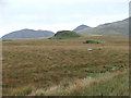
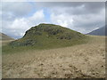
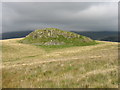
There is a boundary on the north and east sides formed by a wall or stone bank measuring up to 4.7m wide and 0.4m high and fragmented into six separate lengths. The entrance on the eastern side leads into an enclosed area of approximately 0.75ha. In the western side of the enclosure there are ten clearance cairns ranging between 2.15m - 3.85m in diameter and 0.1m - 0.3m in height.
Clearance cairns were built with stone from the surrounding land surface to improve its use for agriculture, and may have served to define field plots.
You may be viewing yesterday's version of this page. To see the most up to date information please register for a free account.
")
")
")
Do not use the above information on other web sites or publications without permission of the contributor.
Nearby Images from Geograph Britain and Ireland:
©2006(licence)
©2006(licence)
©2006(licence)
©2008(licence)
©2015(licence)
The above images may not be of the site on this page, they are loaded from Geograph.
Please Submit an Image of this site or go out and take one for us!
Click here to see more info for this site
Nearby sites
Key: Red: member's photo, Blue: 3rd party photo, Yellow: other image, Green: no photo - please go there and take one, Grey: site destroyed
Download sites to:
KML (Google Earth)
GPX (GPS waypoints)
CSV (Garmin/Navman)
CSV (Excel)
To unlock full downloads you need to sign up as a Contributory Member. Otherwise downloads are limited to 50 sites.
Turn off the page maps and other distractions
Nearby sites listing. In the following links * = Image available
547m NE 46° Eskdale Moor Stone* Standing Stone (Menhir) (NY1801903675)
652m SW 219° Low Longrigg NE* Stone Circle (NY172028)
731m SW 214° Low Longrigg SW* Stone Circle (NY172027)
945m SSW 199° White Moss NE* Stone Circle (NY17300241)
981m SSW 201° White Moss SW* Stone Circle (NY17250239)
991m SSW 194° Brat's Hill* Stone Circle (NY17370234)
1.4km S 179° Boot cairn circle* Cairn (NY17630189)
2.3km NNE 21° Maiden Castle (Eskdale)* Cairn (NY18480543)
3.0km S 169° St Catherine's Well (Boot)* Holy Well or Sacred Spring (NY18150030)
4.5km ESE 115° Hardknott Round Cairn* Round Cairn (NY2171701328)
4.6km ESE 112° Hardknott Roman Fort (MEDIOBOGDUM)* Promontory Fort / Cliff Castle (NY2184001469)
5.2km WSW 253° Irton Pike Ring Cairn Ring Cairn (NY1261601907)
5.5km NNE 12° Viking Timbers at St Olaf's Church Wasdale Head* Museum (NY18830869)
6.3km SSW 197° Devoke Water and Water Crag* Ring Cairn (SD1563397273)
6.8km NW 312° Mecklin Park Cairn (NY126079)
7.0km S 173° Wormkragg Stiner Stone Row / Alignment (SD184963)
7.3km S 175° Brown Rigg Round Cairn* Round Cairn (SD1812396059)
7.9km NE 47° Chapel Well, Smardale Holy Well or Sacred Spring (NY2350008550)
8.5km ESE 119° Ring Cairn, Tarn Brow, Seathwaite Tarn Ring Cairn (SD250990)
8.6km SE 125° Lead Pike, Seathwaite* Ring Cairn (SD246982)
8.7km SE 126° Ring Bank Enclosure, Lead Pike, Seathwaite Tarn Ring Cairn (SD246981)
8.7km SSW 209° Barnscar Settlement, Birkby Fell* Ancient Village or Settlement (SD132958)
8.8km SE 125° Ring Cairn, Lead Pike, Seathwaite Tarn Ring Cairn (SD247981)
8.9km WSW 250° Irton Cross* Ancient Cross (NY0916000455)
9.0km WNW 302° Stockdale Moor* Cairn (NY101082)
View more nearby sites and additional images


 We would like to know more about this location. Please feel free to add a brief description and any relevant information in your own language.
 Wir möchten mehr über diese Stätte erfahren. Bitte zögern Sie nicht, eine kurze Beschreibung und relevante Informationen in Deutsch hinzuzufügen.
 Nous aimerions en savoir encore un peu sur les lieux. S'il vous plaît n'hesitez pas à ajouter une courte description et tous les renseignements pertinents dans votre propre langue.
 Quisieramos informarnos un poco más de las lugares. No dude en añadir una breve descripción y otros datos relevantes en su propio idioma.