<< Our Photo Pages >> Caerau (Cardiff) - Hillfort in Wales in South Glamorgan
Submitted by TauCeti on Wednesday, 01 July 2020 Page Views: 42281
Iron Age and Later PrehistorySite Name: Caerau (Cardiff)Country: Wales County: South Glamorgan Type: Hillfort
Nearest Town: Cardiff Nearest Village: Caerau
Map Ref: ST13377498 Landranger Map Number: 171
Latitude: 51.467133N Longitude: 3.248521W
Condition:
| 5 | Perfect |
| 4 | Almost Perfect |
| 3 | Reasonable but with some damage |
| 2 | Ruined but still recognisable as an ancient site |
| 1 | Pretty much destroyed, possibly visible as crop marks |
| 0 | No data. |
| -1 | Completely destroyed |
| 5 | Superb |
| 4 | Good |
| 3 | Ordinary |
| 2 | Not Good |
| 1 | Awful |
| 0 | No data. |
| 5 | Can be driven to, probably with disabled access |
| 4 | Short walk on a footpath |
| 3 | Requiring a bit more of a walk |
| 2 | A long walk |
| 1 | In the middle of nowhere, a nightmare to find |
| 0 | No data. |
| 5 | co-ordinates taken by GPS or official recorded co-ordinates |
| 4 | co-ordinates scaled from a detailed map |
| 3 | co-ordinates scaled from a bad map |
| 2 | co-ordinates of the nearest village |
| 1 | co-ordinates of the nearest town |
| 0 | no data |
Internal Links:
External Links:
 (PID:24919)")
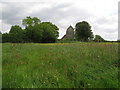
Caerau Hillfort is the third largest Iron Age hillfort in Glamorgan, enclosing 51,000 m², and is surrounded by housing and the A4232. It was once a stronghold of the powerful Silurian tribe who inhabited this part of Wales before the arrival of the Romans. The steep north and south slopes of the ridge are both fortified by three massive ramparts with accompanying ditches, although these are hidden beneath trees and scrub. On the east side the hillfort defences appear to have been reduced to two ramparts in the north and one in south. There seem to have been two entrances to the hillfort, one in the middle of the east side and one west of the south corner. At the east entrance the ramparts curve round to command the approach, but there is no corresponding in turn at the south entrance. An apex in the north-west of the hillfort may be a third entrance, but it has been heavily eroded by water flowing from a spring. The interior, now pasture, was cultivated in the past, and the characteristic traces of rig and furrow agriculture can be seen on aerial photographs. It is traversed by two earthworks which may be old field boundaries, or even the remains of a smaller, earlier hillfort or even a Neolithic causewayed enclosure.
Iron Age and Romano-British pottery as well as a single fragment of a mortarium (1st century AD Roman pouring vessel) have been found from an area north-west of the southern entrance.
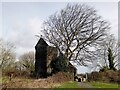
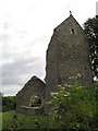
St Mary’s probably dates to the 13th century, and is set within an oval churchyard. Today, it is ruinous and consists of stone walls, mostly stone rubble, nave with south porch and north vestry, chancel and a tower. St Mary’s was restored c. 1885 by John Prichard, the Llandaff diocesan architect, who rebuilt the chancel, while the vestry was added in c. 1920. The church was closed in 1957 and allowed to fall into ruin, but was again restored in 1961 by Father Victor Jones. However, after Father Jones left the diocese, the church was again allowed to fall into disrepair.
To the north-east of St Mary’s church is an oval medieval ringwork measuring 35 m by 20 m. The oval enclosure is defined by a rampart and ditch with an entrance facing southwest towards St Mary's church. It is possible that it is an unrecorded castle belonging to the Bishops of Llandaff, probably contemporary with the church.
Source: Wikipedia and see also the RCAHMW site entry
Note: Do you live near this hillfort? People living near this Cardiff Iron Age hillfort are being asked to dig up a small section of their garden to contribute to an archaeological project. Cardiff people living near hillfort asked to dig up garden.
You may be viewing yesterday's version of this page. To see the most up to date information please register for a free account.
 (PID:24935)")
 (PID:24934)")
 (PID:24920)")
Do not use the above information on other web sites or publications without permission of the contributor.
Nearby Images from Geograph Britain and Ireland:
©2011(licence)
©2016(licence)
©2015(licence)
©2024(licence)
©2011(licence)
The above images may not be of the site on this page, they are loaded from Geograph.
Please Submit an Image of this site or go out and take one for us!
Click here to see more info for this site
Nearby sites
Key: Red: member's photo, Blue: 3rd party photo, Yellow: other image, Green: no photo - please go there and take one, Grey: site destroyed
Download sites to:
KML (Google Earth)
GPX (GPS waypoints)
CSV (Garmin/Navman)
CSV (Excel)
To unlock full downloads you need to sign up as a Contributory Member. Otherwise downloads are limited to 50 sites.
Turn off the page maps and other distractions
Nearby sites listing. In the following links * = Image available
1.0km S 184° Coed-y Cymdda Hillfort (ST13297398)
1.8km SSE 162° Cwrt-yr-ala Hillfort (ST139733)
2.1km ESE 102° Leckwith Round Barrow(s) (ST154745)
2.3km SW 233° Quarrymen Stone* Modern Stone Circle etc (ST115736)
2.6km NW 325° St Fagan's Well Holy Well or Sacred Spring (ST11917712)
2.6km SW 235° Marsyd Round Barrow(s) (ST11217352)
2.8km NW 322° Museum of Welsh Life, St Fagans* Museum (ST117772)
2.8km WSW 249° Vianshill Round Barrow(s) (ST10717401)
3.0km WSW 243° St Lythans Down Round Barrow* Round Barrow(s) (ST10717367)
3.8km NE 34° St Teilo's Well, Llandaff* Holy Well or Sacred Spring (ST15567805)
3.9km SW 218° Goldsland Wood Cave Cave or Rock Shelter (ST109719)
4.2km SW 230° St Lythans* Chambered Tomb (ST10097230)
4.3km WSW 247° Tinkinswood outliers* Rock Outcrop (ST09337334)
4.4km WSW 247° Tinkinswood quarry* Ancient Mine, Quarry or other Industry (ST09337331)
4.4km WSW 246° Tinkinswood 2* Burial Chamber or Dolmen (ST09337327)
4.4km W 267° St Nicholas' Well (Glamorgan)* Holy Well or Sacred Spring (ST08937484)
4.5km WSW 246° Tinkinswood avenue* Stone Row / Alignment (ST09267323)
4.5km WSW 246° Tinkinswood standing stones* Standing Stones (ST09247327)
4.5km WSW 247° Tinkinswood* Chambered Cairn (ST09217330)
4.7km N 4° Pistyll Golau Holy Well or Sacred Spring (ST13787962)
4.7km NW 314° Sant-Y-Nyll Round Barrow(s) (ST10077829)
4.7km ENE 70° Gorsedd Circle (Bute Park)* Modern Stone Circle etc (ST178765)
5.0km S 189° Pencoetre Wood Barrow Round Barrow(s) (ST125701)
5.0km N 360° Radyr Woods Burnt Mound* Artificial Mound (ST13438003)
5.3km ENE 67° National Museum Cardiff* Museum (ST18357696)
View more nearby sites and additional images


 We would like to know more about this location. Please feel free to add a brief description and any relevant information in your own language.
 Wir möchten mehr über diese Stätte erfahren. Bitte zögern Sie nicht, eine kurze Beschreibung und relevante Informationen in Deutsch hinzuzufügen.
 Nous aimerions en savoir encore un peu sur les lieux. S'il vous plaît n'hesitez pas à ajouter une courte description et tous les renseignements pertinents dans votre propre langue.
 Quisieramos informarnos un poco más de las lugares. No dude en añadir una breve descripción y otros datos relevantes en su propio idioma.