

<< Text Pages >> Goldsland Wood Cave - Cave or Rock Shelter in Wales in South Glamorgan
Submitted by Andy B on Thursday, 01 September 2005 Page Views: 12948
Natural PlacesSite Name: Goldsland Wood CaveCountry: Wales County: South Glamorgan Type: Cave or Rock Shelter
Nearest Town: Cardiff Nearest Village: Wenvo
Map Ref: ST109719
Latitude: 51.439062N Longitude: 3.283293W
Condition:
| 5 | Perfect |
| 4 | Almost Perfect |
| 3 | Reasonable but with some damage |
| 2 | Ruined but still recognisable as an ancient site |
| 1 | Pretty much destroyed, possibly visible as crop marks |
| 0 | No data. |
| -1 | Completely destroyed |
| 5 | Superb |
| 4 | Good |
| 3 | Ordinary |
| 2 | Not Good |
| 1 | Awful |
| 0 | No data. |
| 5 | Can be driven to, probably with disabled access |
| 4 | Short walk on a footpath |
| 3 | Requiring a bit more of a walk |
| 2 | A long walk |
| 1 | In the middle of nowhere, a nightmare to find |
| 0 | No data. |
| 5 | co-ordinates taken by GPS or official recorded co-ordinates |
| 4 | co-ordinates scaled from a detailed map |
| 3 | co-ordinates scaled from a bad map |
| 2 | co-ordinates of the nearest village |
| 1 | co-ordinates of the nearest town |
| 0 | no data |
Be the first person to rate this site - see the 'Contribute!' box in the right hand menu.
Internal Links:
External Links:
I have visited· I would like to visit
GenineNeale would like to visit
The remains were found by students studying on the BSc (Hons) Archaeology course working on the Goldsland Wood site, near Wenveo, as one of their four week placements on archaeological research projects.
The students excavated remains of seven humans in a large pit in the mouth of a cave. The remains were found with a flint saw-blade and other stone tools, pieces of pottery, a bone pin, part of a jet bead and belt fastening.
Dr Rick Peterson, Subject Leader for Archaeology at UCLan, said: “The style of pottery and the flint saw-blade suggested that the remains date to around 3000 BC, which means they are over 5000 years old. We also discovered a smaller pit containing the ash from a cremation pyre, but little sign of the cremated body or any evidence where the cremation took place.
“Other human remains have been discovered in caves roughly around this period, from the Nolithic or New Stone Age, but almost all of them were identified years after excavation.
“The Goldsland caves have never been excavated before. We went there hoping to find undisturbed evidence for whatever ritual took place 5000 years ago that led to peoples’ bones being put in caves and we seem to have found it.”
He explained: “At the moment our understanding of these rituals is that first the large pit was dug, probably to make the small cave mouth look much bigger and more impressive. Then the dead were placed in the pit with some of their possessions such as pottery and stone tools. Then once the bodies had become skeletons it seems that most of the bones were then moved to other ritual sites, like the nearby chambered tomb of St Lythans. The pit containing the ash from a cremation is evidence for a different sort of rite - although it probably took place around the same time.”
Rick and his team are carrying out a detailed study of the bones and teeth from the site to try and understand as much as possible about both how these people lived their lives and what precisely happened to their bodies after they died.
Rick added: “Now that we know how well preserved the evidence is at Goldsland we will be going back next year to investigate a much bigger area of the pit and cave mouth. This should give us more human remains to investigate and, even more importantly, much more evidence about how they ended up in the caves.”
The grid reference given is actually of the Goldsland Wood Roman Lead mine, with continued use in the medieval and post-medieval periods.
More: University of Central Lancashire
You may be viewing yesterday's version of this page. To see the most up to date information please register for a free account.
Do not use the above information on other web sites or publications without permission of the contributor.
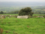
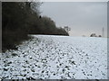
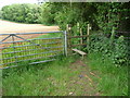
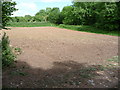
Nearby Images from Geograph Britain and Ireland:
©2010(licence)
©2011(licence)
©2011(licence)
©2011(licence)
©2008(licence)
The above images may not be of the site on this page, they are loaded from Geograph.
Please Submit an Image of this site or go out and take one for us!
Click here to see more info for this site
Nearby sites
Key: Red: member's photo, Blue: 3rd party photo, Yellow: other image, Green: no photo - please go there and take one, Grey: site destroyed
Download sites to:
KML (Google Earth)
GPX (GPS waypoints)
CSV (Garmin/Navman)
CSV (Excel)
To unlock full downloads you need to sign up as a Contributory Member. Otherwise downloads are limited to 50 sites.
Turn off the page maps and other distractions
Nearby sites listing. In the following links * = Image available
901m WNW 295° St Lythans* Chambered Tomb (ST10097230)
1.6km N 10° Marsyd Round Barrow(s) (ST11217352)
1.8km N 353° St Lythans Down Round Barrow* Round Barrow(s) (ST10717367)
1.8km NNE 18° Quarrymen Stone* Modern Stone Circle etc (ST115736)
2.1km NW 310° Tinkinswood 2* Burial Chamber or Dolmen (ST09337327)
2.1km NW 311° Tinkinswood quarry* Ancient Mine, Quarry or other Industry (ST09337331)
2.1km NW 308° Tinkinswood avenue* Stone Row / Alignment (ST09267323)
2.1km N 354° Vianshill Round Barrow(s) (ST10717401)
2.1km NW 312° Tinkinswood outliers* Rock Outcrop (ST09337334)
2.1km NW 309° Tinkinswood standing stones* Standing Stones (ST09247327)
2.2km NW 309° Tinkinswood* Chambered Cairn (ST09217330)
2.4km SE 137° Pencoetre Wood Barrow Round Barrow(s) (ST125701)
3.2km NE 48° Coed-y Cymdda Hillfort (ST13297398)
3.3km ENE 64° Cwrt-yr-ala Hillfort (ST139733)
3.4km WNW 303° Coed-Y-Cwm* Chambered Cairn (ST08117378)
3.5km NW 325° St Nicholas' Well (Glamorgan)* Holy Well or Sacred Spring (ST08937484)
3.6km NW 307° Cottrell Park Standing Stone* Standing Stone (Menhir) (ST0804574124)
3.6km WNW 301° Redland Farm Standing Stone (Menhir) (ST07817382)
3.9km NE 38° Caerau (Cardiff)* Hillfort (ST13377498)
4.8km S 187° Barry Gorsedd Circle* Modern Stone Circle etc (ST1018967130)
5.2km ENE 59° Leckwith Round Barrow(s) (ST154745)
5.3km SSW 198° Westward Corner Round Barrow* Round Barrow(s) (ST0916266901)
5.3km N 10° St Fagan's Well Holy Well or Sacred Spring (ST11917712)
5.4km N 8° Museum of Welsh Life, St Fagans* Museum (ST117772)
5.4km SSW 208° Lower Porthkerry House Platform Ancient Village or Settlement (ST083672)
View more nearby sites and additional images


 We would like to know more about this location. Please feel free to add a brief description and any relevant information in your own language.
 Wir möchten mehr über diese Stätte erfahren. Bitte zögern Sie nicht, eine kurze Beschreibung und relevante Informationen in Deutsch hinzuzufügen.
 Nous aimerions en savoir encore un peu sur les lieux. S'il vous plaît n'hesitez pas à ajouter une courte description et tous les renseignements pertinents dans votre propre langue.
 Quisieramos informarnos un poco más de las lugares. No dude en añadir una breve descripción y otros datos relevantes en su propio idioma.