


<< Our Photo Pages >> St Anno's Church (Llannano) - Misc. Earthwork in Wales in Powys
Submitted by Anne T on Wednesday, 30 January 2019 Page Views: 846
Multi-periodSite Name: St Anno's Church (Llannano)Country: Wales County: Powys Type: Misc. Earthwork
Nearest Town: Rhayader Nearest Village: Llanbister
Map Ref: SO0956874345
Latitude: 52.359675N Longitude: 3.329364W
Condition:
| 5 | Perfect |
| 4 | Almost Perfect |
| 3 | Reasonable but with some damage |
| 2 | Ruined but still recognisable as an ancient site |
| 1 | Pretty much destroyed, possibly visible as crop marks |
| 0 | No data. |
| -1 | Completely destroyed |
| 5 | Superb |
| 4 | Good |
| 3 | Ordinary |
| 2 | Not Good |
| 1 | Awful |
| 0 | No data. |
| 5 | Can be driven to, probably with disabled access |
| 4 | Short walk on a footpath |
| 3 | Requiring a bit more of a walk |
| 2 | A long walk |
| 1 | In the middle of nowhere, a nightmare to find |
| 0 | No data. |
| 5 | co-ordinates taken by GPS or official recorded co-ordinates |
| 4 | co-ordinates scaled from a detailed map |
| 3 | co-ordinates scaled from a bad map |
| 2 | co-ordinates of the nearest village |
| 1 | co-ordinates of the nearest town |
| 0 | no data |
Be the first person to rate this site - see the 'Contribute!' box in the right hand menu.
Internal Links:
External Links:
I have visited· I would like to visit
geoffstickland has visited here
 (PID:199194)")
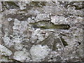
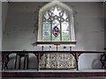
The Journal of Antiquities includes a page for this church, just off the busy A483 Newtown to Llandriodod Wells road - see their entry for St Anno’s Church, Llananno, Powys, Wales. The Journal tells us that whilst: "the churchyard is rectilinear in shape but appears to be built over and on an earlier curved enclosure, which still shows at the north and south sides, suggesting that the site is an ancient one dating back to before the Norman Conquest".
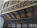
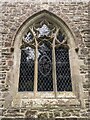
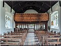
The Journal adds the church is dedicated to an 8th century saint, Anno or Annu, who died in 629AD, and whilst the church was largely rebuilt in the 19th century, it still retains its medieval rood screen, described by Coflein NPRN 153570 as the "most richly decorated and one of the most complete medieval rood screen in Wales". The church is still a small, single-cell church with a "box pew adapted as a vestry"!
Note: Have you visited this site? Do you have any photographs or information to add?
You may be viewing yesterday's version of this page. To see the most up to date information please register for a free account.
 (PID:199193)")
Do not use the above information on other web sites or publications without permission of the contributor.
Nearby Images from Geograph Britain and Ireland:
©2015(licence)
©2023(licence)
©2023(licence)
©2023(licence)
©2023(licence)
The above images may not be of the site on this page, they are loaded from Geograph.
Please Submit an Image of this site or go out and take one for us!
Click here to see more info for this site
Nearby sites
Key: Red: member's photo, Blue: 3rd party photo, Yellow: other image, Green: no photo - please go there and take one, Grey: site destroyed
Download sites to:
KML (Google Earth)
GPX (GPS waypoints)
CSV (Garmin/Navman)
CSV (Excel)
To unlock full downloads you need to sign up as a Contributory Member. Otherwise downloads are limited to 50 sites.
Turn off the page maps and other distractions
Nearby sites listing. In the following links * = Image available
6.7km SW 224° Camlo Hill Stone* Standing Stone (Menhir) (SO048696)
6.8km SW 225° Llyn Dwr Cairn* Cairn (SO04676962)
7.1km E 89° Rhos-Crug Barrows I and II* Round Barrow(s) (SO167743)
7.2km NW 311° Banc Du (Powys)* Stone Circle (SO042792)
7.9km N 10° Rhiw Porthnant* Barrow Cemetery (SO111821)
10.3km N 6° Kerry Ridgeway* Ancient Trackway (SO108846)
10.7km SE 145° Shepherd's Tump* Round Barrow(s) (SO155654)
10.9km N 10° Two Tumps* Round Barrow(s) (SO11688505)
11.3km WSW 240° Ty Lettice Barrows* Round Barrow(s) (SN99606889)
11.9km SW 218° Dolmaengwyn* Standing Stone (Menhir) (SO02056506)
12.0km WSW 241° Ty Lettice* Round Cairn (SN99026866)
12.1km WSW 252° Creggin* Round Barrow(s) (SN980708)
12.3km SE 139° Cwm Bwch Barrows* Round Barrow(s) (SO175649)
12.5km NNE 13° Gwernescob Round Barrow(s) (SO12578647)
12.5km NNE 13° Caebetin Hill Timber Circle (SO126865)
12.5km WSW 241° Cefn Ceidio* Cairn (SN98496842)
12.7km NE 43° Grey Stones* Stone Circle (SO185834)
12.8km S 183° Cefnllys Burnt Mound* Misc. Earthwork (SO086616)
12.8km SSW 209° Wern Stone* Standing Stone (Menhir) (SO03076328)
12.9km S 182° Cefnllys Castle* Hillfort (SO08936146)
12.9km SSW 212° Gwynfan Ring Cairn* Cairn (SO02566344)
13.2km S 187° Bongam Bank* Cairn (SO0779761255)
13.2km NNE 27° Kerry Hill* Stone Circle (SO15768607)
13.4km NNE 27° Shenton's Tump Barrow* Round Barrow(s) (SO15848622)
13.5km WNW 283° Cwm Saesan Stone Circle (SN964776)
View more nearby sites and additional images


 We would like to know more about this location. Please feel free to add a brief description and any relevant information in your own language.
 Wir möchten mehr über diese Stätte erfahren. Bitte zögern Sie nicht, eine kurze Beschreibung und relevante Informationen in Deutsch hinzuzufügen.
 Nous aimerions en savoir encore un peu sur les lieux. S'il vous plaît n'hesitez pas à ajouter une courte description et tous les renseignements pertinents dans votre propre langue.
 Quisieramos informarnos un poco más de las lugares. No dude en añadir una breve descripción y otros datos relevantes en su propio idioma.