<< Our Photo Pages >> Pitcorthie. - Standing Stone (Menhir) in Scotland in Fife
Submitted by Nick on Sunday, 14 December 2003 Page Views: 11131
Neolithic and Bronze AgeSite Name: Pitcorthie. Alternative Name: Aberdour Road, Easter PitcorthieCountry: Scotland County: Fife Type: Standing Stone (Menhir)
Nearest Town: Dunfermline Nearest Village: Pitcorthie
Map Ref: NT11398633 Landranger Map Number: 65
Latitude: 56.061577N Longitude: 3.424623W
Condition:
| 5 | Perfect |
| 4 | Almost Perfect |
| 3 | Reasonable but with some damage |
| 2 | Ruined but still recognisable as an ancient site |
| 1 | Pretty much destroyed, possibly visible as crop marks |
| 0 | No data. |
| -1 | Completely destroyed |
| 5 | Superb |
| 4 | Good |
| 3 | Ordinary |
| 2 | Not Good |
| 1 | Awful |
| 0 | No data. |
| 5 | Can be driven to, probably with disabled access |
| 4 | Short walk on a footpath |
| 3 | Requiring a bit more of a walk |
| 2 | A long walk |
| 1 | In the middle of nowhere, a nightmare to find |
| 0 | No data. |
| 5 | co-ordinates taken by GPS or official recorded co-ordinates |
| 4 | co-ordinates scaled from a detailed map |
| 3 | co-ordinates scaled from a bad map |
| 2 | co-ordinates of the nearest village |
| 1 | co-ordinates of the nearest town |
| 0 | no data |
Internal Links:
External Links:
I have visited· I would like to visit
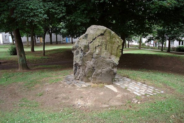
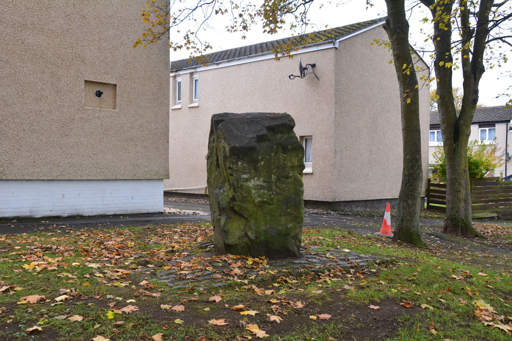
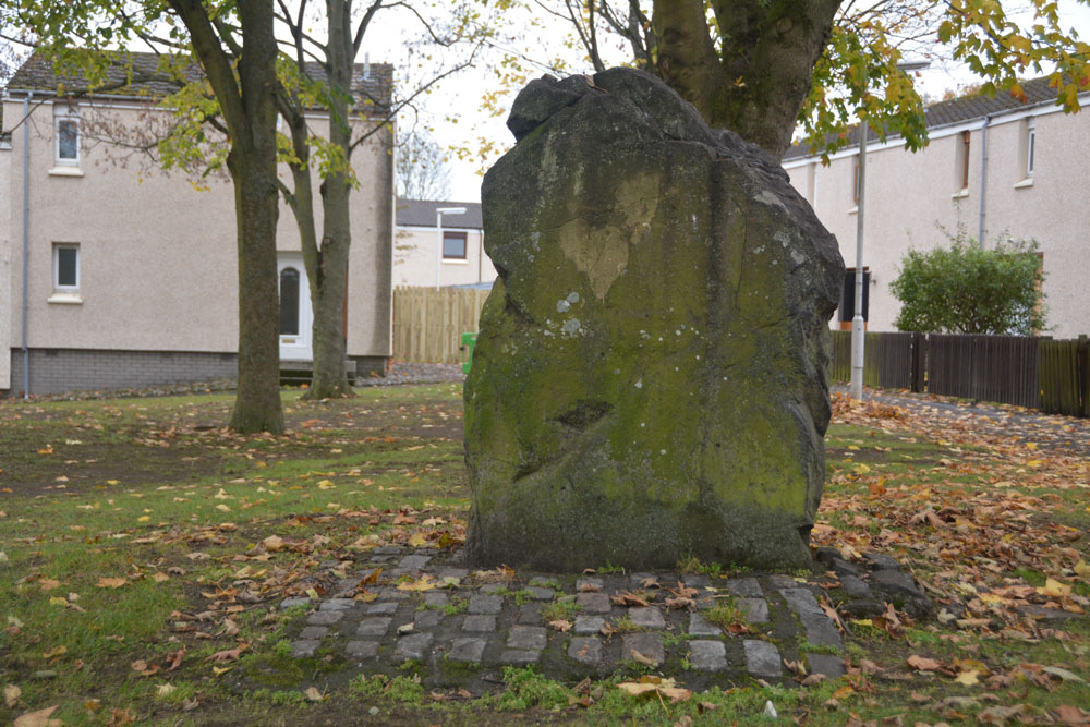
Anne T visited on 2nd Nov 2018 - their rating: Cond: 3 Amb: 2 Access: 4 Pitcorthie Standing Stone, Dunfermline: Our last site visit of our short holiday, and I wish we'd picked a better spot to end on. After the Balfarg Henge, I shouldn't have been surprised that this stone is surprisingly right in the middle of a housing estate, on Standing Stone Walk.
It is a poor, sadly neglected stone; it could just have been a garden feature, especially as it is set in a rectangular pavement of black stones. Like a previous visitor to the stone, being surrounded by rows and rows of houses, we very much felt watched as I was taking photographs and looking around.
hamish have visited here

Although it is a pretty cool stone the presence of 100 living and bedroom windows does not induce a lengthy stay.
NMRS state that the stone appears to have been subjected to fire or heat. It has been subjected to graffiti. This unsculptured standing stone, on the crest of slightly rising ground, is 5'10" high; 3' from the ground, its girth is 11'10". It is of sandstone, main axis N-S, and appears to have been subjected to fire or heat.
When seen in 1959, this stone was as described but by 1972 it had been set in a pavement of granite setts as a "feature" in a green space in a housing estate. Rather a soul-less setting, this stone has little or no 'feel' to it these days, and it is hard to visulaise what it may have looked like in its original setting.
You may be viewing yesterday's version of this page. To see the most up to date information please register for a free account.


Do not use the above information on other web sites or publications without permission of the contributor.
Click here to see more info for this site
Nearby sites
Key: Red: member's photo, Blue: 3rd party photo, Yellow: other image, Green: no photo - please go there and take one, Grey: site destroyed
Download sites to:
KML (Google Earth)
GPX (GPS waypoints)
CSV (Garmin/Navman)
CSV (Excel)
To unlock full downloads you need to sign up as a Contributory Member. Otherwise downloads are limited to 50 sites.
Turn off the page maps and other distractions
Nearby sites listing. In the following links * = Image available
783m SSE 149° North Wood (Dunfermline)* Cairn (NT11788565)
3.5km ESE 106° St Theriot's Well* Holy Well or Sacred Spring (NT147853)
4.9km ESE 111° Fordell Standing Stone* Standing Stone (Menhir) (NT15938446)
5.8km NNE 14° St Ninians Fife Earth Project* Modern Stone Circle etc (NT129919)
6.7km ESE 107° Barns Farm Dalgety Fife* Barrow Cemetery (NT178842)
7.7km E 99° Aberdour Cairn Cairn (NT1985)
7.9km SSW 203° Abercorn Sculptured Stone (NT08147910)
8.0km E 95° St Fillan's Well (Aberdour)* Holy Well or Sacred Spring (NT194854)
8.0km SSE 169° Bell Stane (Queensferry) Standing Stone (Menhir) (NT12827840)
8.3km ESE 115° Inchcolm Sculptured Stone (NT18888260)
8.5km W 271° Tuilyies* Standing Stones (NT02918658)
9.1km SSE 156° Crossall Hill (South Queensferry)* Ancient Cross (NT14907791)
9.3km SSW 200° Justice Stone Standing Stone (Menhir) (NT08087759)
9.6km NW 304° Bandrum* Standing Stones (NT03489187)
10.0km NW 314° Saline hillfort* Hillfort (NT04289335)
10.1km ENE 66° Auchertool Holy Well* Holy Well or Sacred Spring (NT208902)
11.4km NNE 32° Kirkhall, Lochore Stone Circle (NT177958)
11.4km E 86° Binn (Burntisland)* Rock Art (NT2278886891)
11.9km SE 140° Cramond Ancient Village or Settlement (NT18957706)
12.0km SSE 167° Carlowrie (Kirkliston) Rock Art (NT138746)
12.2km NE 36° Hare Law (Fife)* Cairn (NT187961)
12.3km E 90° Craigkennockie (Burntisland) Cairn (NT237861)
12.4km N 3° Fairy Knowe (Gairneybank) Cairn (NT12309874)
12.4km SSE 163° Cat Stane (Kirkliston)* Standing Stone (Menhir) (NT1489374373)
13.1km SSE 151° Cammo Stone* Standing Stone (Menhir) (NT1747774681)
View more nearby sites and additional images


 We would like to know more about this location. Please feel free to add a brief description and any relevant information in your own language.
 Wir möchten mehr über diese Stätte erfahren. Bitte zögern Sie nicht, eine kurze Beschreibung und relevante Informationen in Deutsch hinzuzufügen.
 Nous aimerions en savoir encore un peu sur les lieux. S'il vous plaît n'hesitez pas à ajouter une courte description et tous les renseignements pertinents dans votre propre langue.
 Quisieramos informarnos un poco más de las lugares. No dude en añadir una breve descripción y otros datos relevantes en su propio idioma.