<< Our Photo Pages >> Garn Fawr (Brecon) - Cairn in Wales in Powys
Submitted by TheCaptain on Wednesday, 28 August 2019 Page Views: 706
Neolithic and Bronze AgeSite Name: Garn Fawr (Brecon)Country: Wales
NOTE: This site is 0.7 km away from the location you searched for.
County: Powys Type: Cairn
Nearest Town: Brecon Nearest Village: Llanfrynach
Map Ref: SO04691893
Latitude: 51.860785N Longitude: 3.385443W
Condition:
| 5 | Perfect |
| 4 | Almost Perfect |
| 3 | Reasonable but with some damage |
| 2 | Ruined but still recognisable as an ancient site |
| 1 | Pretty much destroyed, possibly visible as crop marks |
| 0 | No data. |
| -1 | Completely destroyed |
| 5 | Superb |
| 4 | Good |
| 3 | Ordinary |
| 2 | Not Good |
| 1 | Awful |
| 0 | No data. |
| 5 | Can be driven to, probably with disabled access |
| 4 | Short walk on a footpath |
| 3 | Requiring a bit more of a walk |
| 2 | A long walk |
| 1 | In the middle of nowhere, a nightmare to find |
| 0 | No data. |
| 5 | co-ordinates taken by GPS or official recorded co-ordinates |
| 4 | co-ordinates scaled from a detailed map |
| 3 | co-ordinates scaled from a bad map |
| 2 | co-ordinates of the nearest village |
| 1 | co-ordinates of the nearest town |
| 0 | no data |
Internal Links:
External Links:
I have visited· I would like to visit
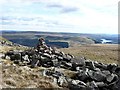
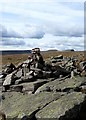
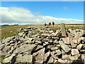
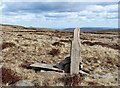
TheCaptain visited on 20th Aug 2019 Marked as Cairn and "Pile of Stones" on the various OS maps, this is a stone cairn on a rock outcrop, part of a low craggy outcrop at the southern end of the flat plateau of Gwaun Cerrig Llwydion. The cairn is 3m in diameter and 0.75m high. The area of the rock outcrop is called Garn Fawr but this appears to be a large marker cairn rather than a burial monument.
 (PID:201891)")
Coflein Record NPRN 246524.
The cairn is 3m in diameter and 0.75m high. The area of the rock outcrop is called Garn Fawr but this appears to be a large marker cairn rather than a burial monument.
You may be viewing yesterday's version of this page. To see the most up to date information please register for a free account.
 (PID:201893)")
 (PID:201892)")
Do not use the above information on other web sites or publications without permission of the contributor.
Nearby Images from Geograph Britain and Ireland:
©2008(licence)
©2013(licence)
©2008(licence)
©2016(licence)
©2008(licence)
The above images may not be of the site on this page, they are loaded from Geograph.
Please Submit an Image of this site or go out and take one for us!
Click here to see more info for this site
Nearby sites
Key: Red: member's photo, Blue: 3rd party photo, Yellow: other image, Green: no photo - please go there and take one, Grey: site destroyed
Download sites to:
KML (Google Earth)
GPX (GPS waypoints)
CSV (Garmin/Navman)
CSV (Excel)
To unlock full downloads you need to sign up as a Contributory Member. Otherwise downloads are limited to 50 sites.
Turn off the page maps and other distractions
Nearby sites listing. In the following links * = Image available
1.3km SE 132° Craig-Y-Fan Ddu* Multiple Stone Rows / Avenue (SO05631806)
1.9km SW 234° Lower Neuadd Reservoir Stone* Standing Stone (Menhir) (SO03091783)
2.0km NNW 328° Fan y Big* Cairn (SO03652066)
2.6km ENE 61° Carn Pica* Cairn (SO06982015)
3.2km SSW 207° Bwlch Gwyn 2 Standing Stone (Menhir) (SO03151611)
3.2km SSW 208° Bwlch Gwyn 1 Standing Stone (Menhir) (SO03121612)
4.3km SSE 163° Y Gaer (Mid Glamorgan)* Hillfort (SO059148)
4.3km SSE 162° Y Gaer Enclosure Hillfort (SO05931478)
4.4km NW 306° Pen y Fan Cairn* Cairn (SO01202159)
4.4km SE 140° Nany Y Ychen Cairn Cairn (SO0745215486)
4.4km E 81° Nant Tarthwyni Hillfort (SO09111951)
4.6km WNW 300° Corn Ddu Cairn* Cairn (SO00752133)
4.8km SE 135° Nany Y Ychen Misc. Earthwork (SO0804015447)
5.2km SE 135° Gwaun Nant Ddu Stone Standing Stone (Menhir) (SO0834815158)
5.3km N 9° Rhiwiau Well* Holy Well or Sacred Spring (SO0565224123)
5.3km SE 133° Gwaun Nant Ddu Ancient Village or Settlement (SO0847615214)
5.4km NNE 20° Coed y Brenhin Hillfort* Ancient Village or Settlement (SO06592396)
5.4km W 280° Pont-ar-daf Timber Circle (SN994200)
5.5km NNE 22° Coed y Caerau* Hillfort (SO069240)
5.5km SSW 204° Nant Gwinau* Stone Row / Alignment (SO02361390)
5.8km ENE 60° Tyle Clydach Hillfort (SO09742175)
5.8km SSE 156° Buarth Y Caerau Hut Circles Ancient Village or Settlement (SO0695213557)
5.8km SSE 163° Waun Rydd Cairn 1 Cairn (SO0625513310)
5.9km SSE 153° Buarth Y Caerau 2 Cairn (SO0729613638)
5.9km NNW 345° Plas-y-Gaer* Hillfort (SO033247)
View more nearby sites and additional images


 We would like to know more about this location. Please feel free to add a brief description and any relevant information in your own language.
 Wir möchten mehr über diese Stätte erfahren. Bitte zögern Sie nicht, eine kurze Beschreibung und relevante Informationen in Deutsch hinzuzufügen.
 Nous aimerions en savoir encore un peu sur les lieux. S'il vous plaît n'hesitez pas à ajouter une courte description et tous les renseignements pertinents dans votre propre langue.
 Quisieramos informarnos un poco más de las lugares. No dude en añadir una breve descripción y otros datos relevantes en su propio idioma.