<< Our Photo Pages >> Stiddrig - Cairn in Scotland in Dumfries and Galloway
Submitted by markj99 on Friday, 26 October 2018 Page Views: 4833
Neolithic and Bronze AgeSite Name: Stiddrig Alternative Name: Broadside Rig; Stidriggs; Stiddrig Long CairnCountry: Scotland County: Dumfries and Galloway Type: Cairn
Nearest Town: Moffat Nearest Village: Kinnelhead
Map Ref: NY04139877 Landranger Map Number: 78
Latitude: 55.273714N Longitude: 3.510557W
Condition:
| 5 | Perfect |
| 4 | Almost Perfect |
| 3 | Reasonable but with some damage |
| 2 | Ruined but still recognisable as an ancient site |
| 1 | Pretty much destroyed, possibly visible as crop marks |
| 0 | No data. |
| -1 | Completely destroyed |
| 5 | Superb |
| 4 | Good |
| 3 | Ordinary |
| 2 | Not Good |
| 1 | Awful |
| 0 | No data. |
| 5 | Can be driven to, probably with disabled access |
| 4 | Short walk on a footpath |
| 3 | Requiring a bit more of a walk |
| 2 | A long walk |
| 1 | In the middle of nowhere, a nightmare to find |
| 0 | No data. |
| 5 | co-ordinates taken by GPS or official recorded co-ordinates |
| 4 | co-ordinates scaled from a detailed map |
| 3 | co-ordinates scaled from a bad map |
| 2 | co-ordinates of the nearest village |
| 1 | co-ordinates of the nearest town |
| 0 | no data |
Internal Links:
External Links:
I have visited· I would like to visit
SumDoood would like to visit
")
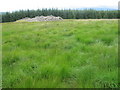
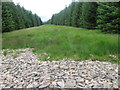
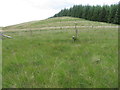
For more information see Canmore ID 66380 which tell us: "This long cairn is situated within a forestry clearing on a terrace on the N shoulder of Broadshaw Rig. Aligned with its long axis from NNW to SSE, it measures 25m in length by up to 2m in height, increasing in width from 10.7m at the NNW to 19m at the SSE end, where there is a shallow facade. The crest and flanks of the cairn have been much disturbed by stone robbing and the construction of sheep shelters, and a stone wall crosses the façade."
Page originally by Vicky
You may be viewing yesterday's version of this page. To see the most up to date information please register for a free account.
")
")
")
")
Do not use the above information on other web sites or publications without permission of the contributor.
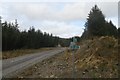
Nearby Images from Geograph Britain and Ireland:
©2007(licence)
©2020(licence)
©2020(licence)
©2020(licence)
©2015(licence)
The above images may not be of the site on this page, they are loaded from Geograph.
Please Submit an Image of this site or go out and take one for us!
Click here to see more info for this site
Nearby sites
Key: Red: member's photo, Blue: 3rd party photo, Yellow: other image, Green: no photo - please go there and take one, Grey: site destroyed
Download sites to:
KML (Google Earth)
GPX (GPS waypoints)
CSV (Garmin/Navman)
CSV (Excel)
To unlock full downloads you need to sign up as a Contributory Member. Otherwise downloads are limited to 50 sites.
Turn off the page maps and other distractions
Nearby sites listing. In the following links * = Image available
1.9km WNW 292° Lonnachie Rig Cairn (NY024995)
5.4km SSE 156° Crunzierton Wood Scooped Settlement* Ancient Village or Settlement (NY0625093750)
6.4km ENE 77° Poldean menhir* Standing Stone (Menhir) (NT1037900011)
6.6km NE 39° Dyke Row* Stone Row / Alignment (NT0837503820)
6.6km E 87° Chapman's Stone* Standing Stone (Menhir) (NY1078398986)
8.0km ESE 106° Pumplaburn* Cairn (NY11869644)
8.3km ESE 120° Skip Knowe* Standing Stone (Menhir) (NY1118094430)
9.0km ESE 104° Wamphray Place* Misc. Earthwork (NY12829648)
9.2km ESE 103° St Cuthbert's Church (Wamphray)* Ancient Cross (NY1307096462)
9.5km SW 234° Gulfhill Rig Cairn (NX963933)
9.8km NNE 30° Moffat Well* Holy Well or Sacred Spring (NT0924007200)
10.2km ESE 105° Kirkhill* Stone Circle (NY1397895929)
10.8km SSE 149° Lochbrow Cursus* Cursus (NY0951489350)
11.0km SSE 150° Lochbrow Prehistoric Landscape* Ancient Village or Settlement (NY0942389153)
11.5km SSE 153° Archwood Hill* Hillfort (NY0911488380)
14.9km SSW 212° Clonfeckle Cairn (NX960863)
15.4km W 278° Mary's Well (East Morton) Holy Well or Sacred Spring (NS88870123)
15.8km WSW 239° My Lady's Well (Brownhill) Holy Well or Sacred Spring (NX90279100)
16.3km NE 46° Peatshiel Sike* Standing Stone (Menhir) (NT16190972)
16.6km WSW 239° Kirkpatrick Hill (Closeburn) Holy Well or Sacred Spring (NX896906)
16.7km NNW 328° Daer valley Ancient Village or Settlement (NS956132)
17.1km WSW 252° Templand Mains* Standing Stone (Menhir) (NX87719396)
17.5km WSW 258° Nith Bridge Cross* Ancient Cross (NX8689095471)
17.6km SSW 204° Kirkmahoe Cursus Cursus (NX96508286)
17.8km W 262° Penpont Cursus Cursus (NX86409658)
View more nearby sites and additional images


 We would like to know more about this location. Please feel free to add a brief description and any relevant information in your own language.
 Wir möchten mehr über diese Stätte erfahren. Bitte zögern Sie nicht, eine kurze Beschreibung und relevante Informationen in Deutsch hinzuzufügen.
 Nous aimerions en savoir encore un peu sur les lieux. S'il vous plaît n'hesitez pas à ajouter une courte description et tous les renseignements pertinents dans votre propre langue.
 Quisieramos informarnos un poco más de las lugares. No dude en añadir una breve descripción y otros datos relevantes en su propio idioma.