


<< Our Photo Pages >> Twr-yr-Hill - Round Barrow(s) in Wales in Denbighshire
Submitted by Postman on Sunday, 21 October 2012 Page Views: 2874
Neolithic and Bronze AgeSite Name: Twr-yr-HillCountry: Wales County: Denbighshire Type: Round Barrow(s)
Nearest Town: Denbigh Nearest Village: Cyffilliog
Map Ref: SJ010581
Latitude: 53.110867N Longitude: 3.480429W
Condition:
| 5 | Perfect |
| 4 | Almost Perfect |
| 3 | Reasonable but with some damage |
| 2 | Ruined but still recognisable as an ancient site |
| 1 | Pretty much destroyed, possibly visible as crop marks |
| 0 | No data. |
| -1 | Completely destroyed |
| 5 | Superb |
| 4 | Good |
| 3 | Ordinary |
| 2 | Not Good |
| 1 | Awful |
| 0 | No data. |
| 5 | Can be driven to, probably with disabled access |
| 4 | Short walk on a footpath |
| 3 | Requiring a bit more of a walk |
| 2 | A long walk |
| 1 | In the middle of nowhere, a nightmare to find |
| 0 | No data. |
| 5 | co-ordinates taken by GPS or official recorded co-ordinates |
| 4 | co-ordinates scaled from a detailed map |
| 3 | co-ordinates scaled from a bad map |
| 2 | co-ordinates of the nearest village |
| 1 | co-ordinates of the nearest town |
| 0 | no data |
Internal Links:
External Links:
")
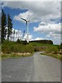
Found to the east of and above Llyn Brenig at the northern part of Clocaenog forest. Park next to a monster wind turbine and walk 250m down a seldom used muddy track and the barrow is just visible through the trees on the left.
Despite the almost overwhelming forest the barrow is still about 8ft tall and in relatively good condition, an inevitable scoop has been taken out of the top, and the entire site is covered in several inches of wet spongy moss. The trees even sheltered me from the rain somewhat letting me take some photos and sit for a while. Because of the trees I can't tell whether it ever had a good view, but it sits on the edge of an eastward sloping hill so would presumably have been visible on the horizon from far off.
You may be viewing yesterday's version of this page. To see the most up to date information please register for a free account.
")
Do not use the above information on other web sites or publications without permission of the contributor.
Nearby Images from Geograph Britain and Ireland:
©2021(licence)

©2006(licence)

©2009(licence)

©2007(licence)

©2009(licence)
The above images may not be of the site on this page, they are loaded from Geograph.
Please Submit an Image of this site or go out and take one for us!
Click here to see more info for this site
Nearby sites
Key: Red: member's photo, Blue: 3rd party photo, Yellow: other image, Green: no photo - please go there and take one, Grey: site destroyed
Download sites to:
KML (Google Earth)
GPX (GPS waypoints)
CSV (Garmin/Navman)
CSV (Excel)
To unlock full downloads you need to sign up as a Contributory Member. Otherwise downloads are limited to 50 sites.
Turn off the page maps and other distractions
Nearby sites listing. In the following links * = Image available
1.8km WNW 289° Tir Mostyn Kerb Cairns Cairn (SH99345870)
2.1km W 267° Brenig 47* Round Cairn (SH98925804)
2.3km SW 220° Brenig 5. Ring Cairn (SH995564)
2.3km SW 218° Brenig 6* Cairn (SH99525631)
2.3km SW 218° Maen Cleddau* Natural Stone / Erratic / Other Natural Feature (SH99515630)
2.5km WSW 252° Nant y Griafolen Hut Circle* Ancient Village or Settlement (SH98605739)
2.5km SW 231° Brenig 51* Cairn (SH98985656)
2.5km WSW 257° Brenig Mesolithic Camp Site Ancient Village or Settlement (SH985576)
2.7km WSW 243° Brenig 46* Cairn (SH98585691)
2.7km W 275° Maen Llwyd (Denbigh) Standing Stone (Menhir) (SH9828058371)
2.8km SW 230° Brenig 8* Round Barrow(s) (SH98805636)
2.8km WSW 250° Brenig 44* Timber Circle (SH98345720)
2.8km WSW 251° Boncyn Arian* Round Barrow(s) (SH98305726)
3.3km WSW 250° Brenig 41* Round Barrow(s) (SH97905702)
3.4km SW 232° Brenig 14 Cairn (SH983561)
3.4km WSW 252° Brenig 40* Round Barrow(s) (SH97785711)
3.8km WSW 247° Brenig 42* Round Barrow(s) (SH975567)
4.2km S 176° Y Foel Frech Stone Circle (SJ012539)
4.2km SSE 147° Capel Hiraethog III* Stone Circle (SJ032545)
4.4km SE 143° Capel Hiraethog ring cairn* Ring Cairn (SJ036545)
4.5km WNW 290° Gorsedd Bran* Barrow Cemetery (SH968597)
6.4km SE 140° Bryn Beddau North* Ring Cairn (SJ0508053130)
6.4km SE 138° Bedd Emlyn* Cairn (SJ0525053240)
6.5km SE 141° Bryn Beddau South* Cairn (SJ0505052970)
6.6km SSW 201° Caer Ddunod* Hillfort (SH985520)
View more nearby sites and additional images


 We would like to know more about this location. Please feel free to add a brief description and any relevant information in your own language.
 Wir möchten mehr über diese Stätte erfahren. Bitte zögern Sie nicht, eine kurze Beschreibung und relevante Informationen in Deutsch hinzuzufügen.
 Nous aimerions en savoir encore un peu sur les lieux. S'il vous plaît n'hesitez pas à ajouter une courte description et tous les renseignements pertinents dans votre propre langue.
 Quisieramos informarnos un poco más de las lugares. No dude en añadir una breve descripción y otros datos relevantes en su propio idioma.