

<< Our Photo Pages >> Bryn Beddau South - Cairn in Wales in Denbighshire
Submitted by Postman on Monday, 01 October 2012 Page Views: 8145
Neolithic and Bronze AgeSite Name: Bryn Beddau SouthCountry: Wales County: Denbighshire Type: Cairn
Nearest Town: Ruthin Nearest Village: Clawdd-Newydd
Map Ref: SJ0505052970
Latitude: 53.065504N Longitude: 3.418429W
Condition:
| 5 | Perfect |
| 4 | Almost Perfect |
| 3 | Reasonable but with some damage |
| 2 | Ruined but still recognisable as an ancient site |
| 1 | Pretty much destroyed, possibly visible as crop marks |
| 0 | No data. |
| -1 | Completely destroyed |
| 5 | Superb |
| 4 | Good |
| 3 | Ordinary |
| 2 | Not Good |
| 1 | Awful |
| 0 | No data. |
| 5 | Can be driven to, probably with disabled access |
| 4 | Short walk on a footpath |
| 3 | Requiring a bit more of a walk |
| 2 | A long walk |
| 1 | In the middle of nowhere, a nightmare to find |
| 0 | No data. |
| 5 | co-ordinates taken by GPS or official recorded co-ordinates |
| 4 | co-ordinates scaled from a detailed map |
| 3 | co-ordinates scaled from a bad map |
| 2 | co-ordinates of the nearest village |
| 1 | co-ordinates of the nearest town |
| 0 | no data |
Internal Links:
External Links:
I have visited· I would like to visit
Bladup has visited here
")
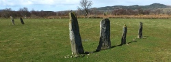
Bryn Beddau South (cairn) is a flat ring of stones, just to the north of a linear break in the trees, which may be mistakenly interpreted as a track on some maps. The stones are in a clearing with bilberry covering most of it. Observations as of August 2022. Best approached by going through two wooden fences, slightly separated, which act as an entrance. Edited by Tim Prevett 25/08/22
You may be viewing yesterday's version of this page. To see the most up to date information please register for a free account.
")
")
")
")
Do not use the above information on other web sites or publications without permission of the contributor.
Nearby Images from Geograph Britain and Ireland:

©2015(licence)

©2016(licence)
©2007(licence)
©2007(licence)
©2015(licence)
The above images may not be of the site on this page, they are loaded from Geograph.
Please Submit an Image of this site or go out and take one for us!
Click here to see more info for this site
Nearby sites
Key: Red: member's photo, Blue: 3rd party photo, Yellow: other image, Green: no photo - please go there and take one, Grey: site destroyed
Download sites to:
KML (Google Earth)
GPX (GPS waypoints)
CSV (Garmin/Navman)
CSV (Excel)
To unlock full downloads you need to sign up as a Contributory Member. Otherwise downloads are limited to 50 sites.
Turn off the page maps and other distractions
Nearby sites listing. In the following links * = Image available
163m N 9° Bryn Beddau North* Ring Cairn (SJ0508053130)
336m NE 35° Bedd Emlyn* Cairn (SJ0525053240)
499m SW 219° Bryn Beddau Stone Circle* Stone Circle (SJ0472952587)
644m SSW 203° Maen Llwyd (Denbighshire)* Standing Stone (Menhir) (SJ04795238)
944m SW 217° Caerau Two (Denbighshire)* Ancient Village or Settlement (SJ0446552227)
1.1km SW 221° Caerau One (Denbighshire) Ancient Village or Settlement (SJ0432252169)
2.0km SE 136° Ffynnon Sarah* Holy Well or Sacred Spring (SJ064515)
2.1km NW 315° Capel Hiraethog ring cairn* Ring Cairn (SJ036545)
2.4km NW 309° Capel Hiraethog III* Stone Circle (SJ032545)
3.4km SW 232° Preseb y Fawch Frech* Stone Circle (SJ023509)
3.8km S 181° Dinas Melin-y-Wig* Hillfort (SJ049492)
3.9km WNW 282° Y Foel Frech Stone Circle (SJ012539)
5.5km ENE 60° Carreg Clocaenog* Standing Stone (Menhir) (SJ0991755605)
5.8km ENE 70° Pen-Y-Gaer (Efenechtyd) Hillfort (SJ10585484)
6.4km WNW 300° Brenig 6* Cairn (SH99525631)
6.4km WNW 300° Maen Cleddau* Natural Stone / Erratic / Other Natural Feature (SH99515630)
6.5km WNW 301° Brenig 5. Ring Cairn (SH995564)
6.5km NW 321° Twr-yr-Hill* Round Barrow(s) (SJ010581)
6.6km SSE 156° Ffynnon Beuno (Gwyddelwern)* Holy Well or Sacred Spring (SJ07584692)
6.6km W 260° Caer Ddunod* Hillfort (SH985520)
7.0km WNW 300° Brenig 51* Cairn (SH98985656)
7.1km WNW 297° Brenig 8* Round Barrow(s) (SH98805636)
7.4km ESE 121° Tom Dongen Round Barrow* Round Barrow(s) (SJ1137049060)
7.4km WNW 294° Brenig 14 Cairn (SH983561)
7.6km WNW 300° Brenig 46* Cairn (SH98585691)
View more nearby sites and additional images


 We would like to know more about this location. Please feel free to add a brief description and any relevant information in your own language.
 Wir möchten mehr über diese Stätte erfahren. Bitte zögern Sie nicht, eine kurze Beschreibung und relevante Informationen in Deutsch hinzuzufügen.
 Nous aimerions en savoir encore un peu sur les lieux. S'il vous plaît n'hesitez pas à ajouter une courte description et tous les renseignements pertinents dans votre propre langue.
 Quisieramos informarnos un poco más de las lugares. No dude en añadir una breve descripción y otros datos relevantes en su propio idioma.