<< Our Photo Pages >> Creggin - Round Barrow(s) in Wales in Powys
Submitted by postman on Tuesday, 13 November 2012 Page Views: 4497
Neolithic and Bronze AgeSite Name: CregginCountry: Wales
NOTE: This site is 3.3 km away from the location you searched for.
County: Powys Type: Round Barrow(s)
Nearest Town: Rhayader Nearest Village: St Harmon
Map Ref: SN980708
Latitude: 52.325783N Longitude: 3.498096W
Condition:
| 5 | Perfect |
| 4 | Almost Perfect |
| 3 | Reasonable but with some damage |
| 2 | Ruined but still recognisable as an ancient site |
| 1 | Pretty much destroyed, possibly visible as crop marks |
| 0 | No data. |
| -1 | Completely destroyed |
| 5 | Superb |
| 4 | Good |
| 3 | Ordinary |
| 2 | Not Good |
| 1 | Awful |
| 0 | No data. |
| 5 | Can be driven to, probably with disabled access |
| 4 | Short walk on a footpath |
| 3 | Requiring a bit more of a walk |
| 2 | A long walk |
| 1 | In the middle of nowhere, a nightmare to find |
| 0 | No data. |
| 5 | co-ordinates taken by GPS or official recorded co-ordinates |
| 4 | co-ordinates scaled from a detailed map |
| 3 | co-ordinates scaled from a bad map |
| 2 | co-ordinates of the nearest village |
| 1 | co-ordinates of the nearest town |
| 0 | no data |
Internal Links:
External Links:
")
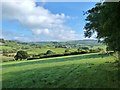
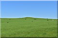
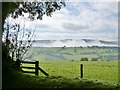
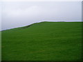
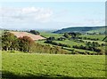
From Rhayader take the B4518 to St Harmon but turn almost immediately left, towards Nantserth and Tynshimley farms, turn right when you get to a crossroads, a road crossing a rough dirt track, follow the track as far as you want, there are plenty of opportunistic parking places. Then walk for about ten minutes the barrow is in the corner of the field past the last house.
About two meters tall and a good twenty odd across, and fair covered in thistles. Moel Hywel at over five hundred meters high dominates the near surroundings. Standing on top of the barrow the south west view opens up as far as Esgair Penygarreg, itself cairn topped, but then all the hills round there are.
You may be viewing yesterday's version of this page. To see the most up to date information please register for a free account.
")
")
Do not use the above information on other web sites or publications without permission of the contributor.
Nearby Images from Geograph Britain and Ireland:
©2016(licence)
©2017(licence)
©2016(licence)
©2006(licence)
©2016(licence)
The above images may not be of the site on this page, they are loaded from Geograph.
Please Submit an Image of this site or go out and take one for us!
Click here to see more info for this site
Nearby sites
Key: Red: member's photo, Blue: 3rd party photo, Yellow: other image, Green: no photo - please go there and take one, Grey: site destroyed
Download sites to:
KML (Google Earth)
GPX (GPS waypoints)
CSV (Garmin/Navman)
CSV (Excel)
To unlock full downloads you need to sign up as a Contributory Member. Otherwise downloads are limited to 50 sites.
Turn off the page maps and other distractions
Nearby sites listing. In the following links * = Image available
2.1km WNW 289° Marteg Valley* Cairn (SN95997155)
2.4km SSE 153° Ty Lettice* Round Cairn (SN99026866)
2.4km SSE 167° Cefn Ceidio* Cairn (SN98496842)
2.5km SE 139° Ty Lettice Barrows* Round Barrow(s) (SN99606889)
3.7km WSW 253° Maen Serth* Standing Stone (Menhir) (SN944698)
4.4km WSW 257° Clap yr Arian* Cairn (SN937699)
4.7km WSW 247° Banc Trehesglog Cairn* Cist (SN93636909)
4.7km S 171° Carn Wen - The Druid's circle* Ring Cairn (SN98686614)
4.9km WSW 254° Briddell Felen B* Chambered Tomb (SN93256957)
4.9km WSW 255° Briddell Felen A* Standing Stone (Menhir) (SN93226964)
5.2km WSW 248° Tre Heslog Stone Row* Stone Row / Alignment (SN9310668922)
5.2km WSW 248° Tre Heslog Cist* Cist (SN931689)
5.4km W 267° Maengwyngweddew* Standing Stone (Menhir) (SN926706)
5.7km NW 310° Gwastad Stone Row Stone Row / Alignment (SN9368974584)
6.3km WSW 250° Crugyn Gwyddel Cairn* Cairn (SN91976877)
6.6km W 270° Blaen Fign Cairn 2* Cairn (SN914709)
6.8km E 99° Llyn Dwr Cairn* Cairn (SO04676962)
6.8km NNW 334° Cwm y Saeson Standing Stone* Standing Stones (SN9507776977)
6.9km E 99° Camlo Hill Stone* Standing Stone (Menhir) (SO048696)
7.0km NNW 346° Cwm Saesan Stone Circle (SN964776)
7.0km SE 144° Dolmaengwyn* Standing Stone (Menhir) (SO02056506)
7.0km NNW 345° Henriw* Standing Stone (Menhir) (SN9637577642)
7.1km WSW 246° Esgair Pen-y-Garreg* Stone Row / Alignment (SN9145468091)
7.1km S 182° Llanwrthwl* Standing Stone (Menhir) (SN9757263720)
7.1km NNW 345° Cae Garreg Stone Row / Alignment (SN963777)
View more nearby sites and additional images


 We would like to know more about this location. Please feel free to add a brief description and any relevant information in your own language.
 Wir möchten mehr über diese Stätte erfahren. Bitte zögern Sie nicht, eine kurze Beschreibung und relevante Informationen in Deutsch hinzuzufügen.
 Nous aimerions en savoir encore un peu sur les lieux. S'il vous plaît n'hesitez pas à ajouter une courte description et tous les renseignements pertinents dans votre propre langue.
 Quisieramos informarnos un poco más de las lugares. No dude en añadir una breve descripción y otros datos relevantes en su propio idioma.