<< Our Photo Pages >> Learable Hill S - Stone Circle in Scotland in Highlands
Submitted by Anonymous on Tuesday, 09 July 2002 Page Views: 7270
Neolithic and Bronze AgeSite Name: Learable Hill SCountry: Scotland County: Highlands Type: Stone Circle
Nearest Village: Kildonan Lodge / Borrobol Lodge
Map Ref: NC89162351 Landranger Map Number: 17
Latitude: 58.186449N Longitude: 3.886767W
Condition:
| 5 | Perfect |
| 4 | Almost Perfect |
| 3 | Reasonable but with some damage |
| 2 | Ruined but still recognisable as an ancient site |
| 1 | Pretty much destroyed, possibly visible as crop marks |
| 0 | No data. |
| -1 | Completely destroyed |
| 5 | Superb |
| 4 | Good |
| 3 | Ordinary |
| 2 | Not Good |
| 1 | Awful |
| 0 | No data. |
| 5 | Can be driven to, probably with disabled access |
| 4 | Short walk on a footpath |
| 3 | Requiring a bit more of a walk |
| 2 | A long walk |
| 1 | In the middle of nowhere, a nightmare to find |
| 0 | No data. |
| 5 | co-ordinates taken by GPS or official recorded co-ordinates |
| 4 | co-ordinates scaled from a detailed map |
| 3 | co-ordinates scaled from a bad map |
| 2 | co-ordinates of the nearest village |
| 1 | co-ordinates of the nearest town |
| 0 | no data |
Be the first person to rate this site - see the 'Contribute!' box in the right hand menu.
Internal Links:
External Links:
I have visited· I would like to visit
SumDoood would like to visit
SandyG visited on 1st Sep 2016 - their rating: Cond: 2 Amb: 4 Access: 3
tom_bullock have visited here
")
Update November 2019: This stone circle is recorded as Canmore ID 6716 (Learable Hill) and as MHG9517 (Stone Circle, Learable Hill) on the Highland HER.
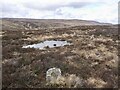
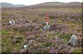
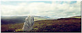
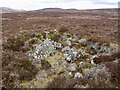
Canmore tells us: "This elliptical stone circle lies on level ground some 90m WNW of the standing stone, which occupies the brow of the SE spur of Learable Hill, in an area much encumbered by small cairns; it measures 20m from NE to SW by 17.5m transversely. Seven upright stones were located, none above 0.5m in height, and there was at least one recumbent stone, which may have been part of the circle. A small cairn occupies the centre of the circle".
For more information about this complex of stone rows, stone circle, standing stone and a cairn, see 'nearby sites' below, and The Stone Rows of Great Britain's entries for Learable Hill Stone Rows, all of which include photographs and a plan of the monuments in the immediate area:
Learable Hill, Row 1;
Learable Hill, Row 2;
Learable Hill, Row 3; and
Learable Hill, Row 4.
You may be viewing yesterday's version of this page. To see the most up to date information please register for a free account.
")
")
Do not use the above information on other web sites or publications without permission of the contributor.
Nearby Images from Geograph Britain and Ireland:
©2023(licence)
©2015(licence)
©2018(licence)
©2011(licence)
©2023(licence)
The above images may not be of the site on this page, they are loaded from Geograph.
Please Submit an Image of this site or go out and take one for us!
Click here to see more info for this site
Nearby sites
Key: Red: member's photo, Blue: 3rd party photo, Yellow: other image, Green: no photo - please go there and take one, Grey: site destroyed
Download sites to:
KML (Google Earth)
GPX (GPS waypoints)
CSV (Garmin/Navman)
CSV (Excel)
To unlock full downloads you need to sign up as a Contributory Member. Otherwise downloads are limited to 50 sites.
![]()
Turn off the page maps and other distractions
Nearby sites listing. In the following links * = Image available
49m ENE 64° Learable Hill Row 2* Stone Row / Alignment (NC8920523530)
61m NE 52° Learable Hill Row 1* Stone Row / Alignment (NC8920923546)
98m E 98° Learable Hill Cross Incised Stone* Early Christian Sculptured Stone (NC8925723493)
99m ENE 65° Learable Hill* Multiple Stone Rows / Avenue (NC8925123550)
121m E 95° Learable Hill Row 3* Stone Row / Alignment (NC8928123496)
122m ESE 110° Learable Hill Row 4* Stone Row / Alignment (NC8927423466)
680m NNE 28° Learable Hill N* Stone Circle (NC895241)
1.6km N 359° Suisgill Souterrian* Souterrain (Fogou, Earth House) (NC89172511)
1.6km NNE 25° Carn Nam Buth* Broch or Nuraghe (NC89892498)
1.8km NNW 346° Suisgill Broch* Broch or Nuraghe (NC88752530)
5.0km NNW 340° Kinbrace Burn* Chambered Cairn (NC87572830)
5.5km SE 146° Kilearnan Broch* Broch or Nuraghe (NC92161887)
6.0km NNW 339° Kinbrace Hill 1* Cairn (NC87172915)
6.0km SE 140° Kilearnan Hill* Broch or Nuraghe (NC92931882)
6.1km NW 307° Feranach* Broch or Nuraghe (NC84412730)
6.3km NNW 337° Kinbrace Hill 2* Chambered Cairn (NC86882935)
7.0km SE 129° Balvalaich* Broch or Nuraghe (NC94521898)
7.7km NNW 342° Creag Nan Caorach Chambered Cairn* Chambered Cairn (NC870309)
7.8km SE 131° Gailiable Broch or Nuraghe (NC94871823)
7.8km NNW 341° Creag Nan Caorach Cairn Cairn (NC868310)
7.9km NNW 339° Creag Nan Caorach Hut Circles* Ancient Village or Settlement (NC865310)
8.0km SE 126° Kildonan SW* Multiple Stone Rows / Avenue (NC9550918564)
8.5km WNW 286° Altanduin Broch or Nuraghe (NC80972605)
8.6km NNW 342° Creag Nan Caorach Hut Circles* Ancient Village or Settlement (NC867318)
8.6km ESE 120° Kildonan NE* Multiple Stone Rows / Avenue (NC96541898)
View more nearby sites and additional images

")
 We would like to know more about this location. Please feel free to add a brief description and any relevant information in your own language.
 Wir möchten mehr über diese Stätte erfahren. Bitte zögern Sie nicht, eine kurze Beschreibung und relevante Informationen in Deutsch hinzuzufügen.
 Nous aimerions en savoir encore un peu sur les lieux. S'il vous plaît n'hesitez pas à ajouter une courte description et tous les renseignements pertinents dans votre propre langue.
 Quisieramos informarnos un poco más de las lugares. No dude en añadir una breve descripción y otros datos relevantes en su propio idioma.