Featured: Ark of Secrets - Neolithic spirit alive in the Middle Ages

Ark of Secrets - Neolithic spirit alive in the Middle Ages

Random Image


Clach na h'Annait

Avebury Archaeology Map

Avebury Archaeology Map

Who's Online

There are currently, 252 guests and 2 members online.

You are a guest. To join in, please register for free by clicking here

Sponsors

<< Our Photo Pages >> Learable Hill - Multiple Stone Rows / Avenue in Scotland in Highlands

Submitted by Tom_Bullock on Tuesday, 01 October 2002  Page Views: 12552

Neolithic and Bronze AgeSite Name: Learable Hill
Country: Scotland County: Highlands Type: Multiple Stone Rows / Avenue
Nearest Town: Helmsdale  Nearest Village: Torrish
Map Ref: NC8925123550  Landranger Map Number: 17
Latitude: 58.186831N  Longitude: 3.885239W
Condition:
5Perfect
4Almost Perfect
3Reasonable but with some damage
2Ruined but still recognisable as an ancient site
1Pretty much destroyed, possibly visible as crop marks
0No data.
-1Completely destroyed
4 Ambience:
5Superb
4Good
3Ordinary
2Not Good
1Awful
0No data.
no data Access:
5Can be driven to, probably with disabled access
4Short walk on a footpath
3Requiring a bit more of a walk
2A long walk
1In the middle of nowhere, a nightmare to find
0No data.
no data Accuracy:
5co-ordinates taken by GPS or official recorded co-ordinates
4co-ordinates scaled from a detailed map
3co-ordinates scaled from a bad map
2co-ordinates of the nearest village
1co-ordinates of the nearest town
0no data
5

Internal Links:
External Links:

I have visited· I would like to visit

SumDoood would like to visit

SandyG visited on 1st Sep 2016 - their rating: Cond: 3 Amb: 4 Access: 3 Car parking is available at NC 90042 23237. From here carefully cross the suspension bridge across the River Helmsdale. Follow the path to the railway crossing. Ensure there are no trains coming before crossing and make sure the gates are carefully closed. Follow the path up the hill to NC 89373 23682 and then walk south west for about 200m.

tom_bullock have visited here

Learable Hill
Learable Hill submitted by Tom_Bullock : Photo used by kind permission of Tom Bullock. More details of this location are to be found on his Stone Circles and Rows CD-ROM (Vote or comment on this photo)
A complex of Multiple Stone Rows in Highlands including a Northern Triple Row, Central Quadruple Row and Southern 10 Rows.

Each of the four stone rows and the standing stone has its own individual site page - see 'nearby sites' below.

This page is intended to act as the 'summary' page for all the Learable Hill sites, and will capture all the photographs of the monuments with the name 'Learable Hill' in their name. For more details of each site, see the individual site page, listed in the 'nearby sites' list below..

With thanks to SandyG of Stone Rows of Great Britain for the information to complete these site pages.
You may be viewing yesterday's version of this page. To see the most up to date information please register for a free account.


Learable Hill N
Learable Hill N submitted by AdamCircle : A faint ring mark on a fallen stone. From the late Bruce Adams' Inverness photo album, more: Flickr or PDF here. (Vote or comment on this photo)

Learable Hill N
Learable Hill N submitted by AdamCircle : From the late Bruce Adams' Inverness photo album, more: Flickr or PDF here. (Vote or comment on this photo)

Learable Hill N
Learable Hill N submitted by AdamCircle (Vote or comment on this photo)

Learable Hill S
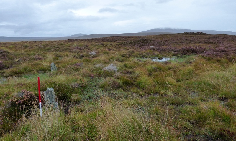
Learable Hill S submitted by SandyG : View from west (Scale 1m). 1 September 2016. (Vote or comment on this photo)

Learable Hill S
Learable Hill S submitted by SandyG : View from west. Excavated cairn visible on the hill beyond the circle (Scale 1m). 1 September 2016. (Vote or comment on this photo)

Learable Hill
Learable Hill submitted by SandyG : Standing stone in the middle of the stone row complex. View from south. 1 September 2016.

Learable Hill
Learable Hill submitted by SandyG : Standing stone in the centre of the stone row complex. View from the south. 1 September 2016.

Learable Hill Row 4
Learable Hill Row 4 submitted by SandyG : Learable Hill Row 4. View from above and the south east of the alignment (Scale 1m). 1 September 2016.

Learable Hill Row 4
Learable Hill Row 4 submitted by SandyG : Learable Hill Row 4. View from above and the south of the western part of the alignment (Scale 1m). 1 September 2016.

Learable Hill Row 4
Learable Hill Row 4 submitted by SandyG : Learable Hill Row 4. View from above and the south east of the western part of the alignment (Scale 1m). 1 September 2016.

Learable Hill Row 4
Learable Hill Row 4 submitted by SandyG : Learable Hill Row 4. Stone row approaching the summit of Learable Hill. Standing stone and cairns on the skyline. View from south (Scale 1m). 1 September 2016.

Learable Hill Row 4
Learable Hill Row 4 submitted by SandyG : Learable Hill Row 4. The western row of stones is the most complete and photogenic. View from south (Scale 1m). 1 September 2016.

Learable Hill Row 4
Learable Hill Row 4 submitted by SandyG : Learable Hill Row 4. Three stones forming part of the western side of the alignment. View from south east (Scale 1m). 1 September 2016.

Learable Hill Row 4
Learable Hill Row 4 submitted by SandyG : Learable Hill Row 4. Row of stones leading up the southern slope of Learable Hill. View from south (Scale 1m). 1 September 2016.

Learable Hill Row 4
Learable Hill Row 4 submitted by SandyG : Learable Hill Row 4. Row of stones leading up the hill towards the central standing stone. View from south. 1 September 2016.

Learable Hill Row 3
Learable Hill Row 3 submitted by SandyG : Stones in the foreground may form part of stone row 3 identified by the Royal Commission. View from east (Scale 1m). The large stone on the skyline is the standing stone in the centre of the complex. 1 September 2016.

Learable Hill Row 2
Learable Hill Row 2 submitted by SandyG : Learable Hill Row 2. The most impressive part of the alignment. View from the west (Scale 1m).

Learable Hill Row 2
Learable Hill Row 2 submitted by SandyG : Row 2 in the foreground with Row 1 in the background. View from the east (Scale 1m). 1 September 2016.

Learable Hill Row 2
Learable Hill Row 2 submitted by SandyG : Looking east along Learable Hill row 2 (Scale 1m). The triangular peaks on the skyline may have been of particular interest to the stone row builders. 1 September 2016.

Learable Hill Row 2
Learable Hill Row 2 submitted by SandyG : Western part of the Learable Hill rows 1 and 2. View from above and the east (Scale 1m). 1 September 2016.

Learable Hill Row 2
Learable Hill Row 2 submitted by SandyG : Learable Hill Row 2. A pair of rows forming part of this alignment. View from above and west (Scale 1m). 1 September 2016.

Learable Hill Row 2
Learable Hill Row 2 submitted by SandyG : View from above and the west of Learable Hill Row 2 (Scale 1m). 1 September 2016.

Learable Hill Row 2
Learable Hill Row 2 submitted by SandyG : View from above and east of Learable Hill Row 2 (Scale 1m). 1 September 2016.

Learable Hill Row 2
Learable Hill Row 2 submitted by SandyG : Looking west along the Learable Hill 2 row (Scale 1m). 1 September 2016.

Learable Hill Row 1
Learable Hill Row 1 submitted by SandyG : View from above and south west of Learable Hill Row 1 (Scale 1m). 1 September 2016.

These are just the first 25 photos of Learable Hill. If you log in with a free user account you will be able to see our entire collection.

Do not use the above information on other web sites or publications without permission of the contributor.
Click here to see more info for this site

Nearby sites

Click here to view sites on an interactive OS map

Key: Red: member's photo, Blue: 3rd party photo, Yellow: other image, Green: no photo - please go there and take one, Grey: site destroyed

Download sites to:
KML (Google Earth)
GPX (GPS waypoints)
CSV (Garmin/Navman)
CSV (Excel)

To unlock full downloads you need to sign up as a Contributory Member. Otherwise downloads are limited to 50 sites.

Stone Rows of Great Britain by Sandy Gerrard


Turn off the page maps and other distractions

Nearby sites listing. In the following links * = Image available
 42m W 263° Learable Hill Row 1* Stone Row / Alignment (NC8920923546)
 50m WSW 245° Learable Hill Row 2* Stone Row / Alignment (NC8920523530)
 57m S 172° Learable Hill Cross Incised Stone* Early Christian Sculptured Stone (NC8925723493)
 62m SSE 149° Learable Hill Row 3* Stone Row / Alignment (NC8928123496)
 87m SSE 163° Learable Hill Row 4* Stone Row / Alignment (NC8927423466)
 99m WSW 245° Learable Hill S* Stone Circle (NC89162351)
 603m NNE 23° Learable Hill N* Stone Circle (NC895241)
 1.6km N 355° Suisgill Souterrian* Souterrain (Fogou, Earth House) (NC89172511)
 1.6km NNE 22° Carn Nam Buth* Broch or Nuraghe (NC89892498)
 1.8km NNW 342° Suisgill Broch* Broch or Nuraghe (NC88752530)
 5.0km NNW 339° Kinbrace Burn* Chambered Cairn (NC87572830)
 5.5km SSE 147° Kilearnan Broch* Broch or Nuraghe (NC92161887)
 6.0km NNW 338° Kinbrace Hill 1* Cairn (NC87172915)
 6.0km SE 141° Kilearnan Hill* Broch or Nuraghe (NC92931882)
 6.1km NW 306° Feranach* Broch or Nuraghe (NC84412730)
 6.3km NNW 336° Kinbrace Hill 2* Chambered Cairn (NC86882935)
 7.0km SE 129° Balvalaich* Broch or Nuraghe (NC94521898)
 7.7km NNW 341° Creag Nan Caorach Chambered Cairn* Chambered Cairn (NC870309)
 7.7km SE 132° Gailiable Broch or Nuraghe (NC94871823)
 7.8km NNW 340° Creag Nan Caorach Cairn Cairn (NC868310)
 7.9km NNW 338° Creag Nan Caorach Hut Circles* Ancient Village or Settlement (NC865310)
 8.0km SE 127° Kildonan SW* Multiple Stone Rows / Avenue (NC9550918564)
 8.6km ESE 121° Kildonan NE* Multiple Stone Rows / Avenue (NC96541898)
 8.6km NNW 341° Creag Nan Caorach Hut Circles* Ancient Village or Settlement (NC867318)
 8.6km WNW 285° Altanduin Broch or Nuraghe (NC80972605)
View more nearby sites and additional images

<< Lumbister, N Yell

Loch Rimsdale >>

Please add your thoughts on this site

Caithness Archaeology: Aspects of Prehistory

Caithness Archaeology: Aspects of Prehistory

Web Links for Learable Hill

Stone Rows of Great Britain by Sandy Gerrard

Sponsors

Auto-Translation (Google)

Translate from English into:

"Learable Hill" | Login/Create an Account | 2 News and Comments
  
Go back to top of page    Comments are owned by the poster. We aren't responsible for their content.
Learable Hill: an archaeological tour, Sat 21 July by Andy B on Saturday, 14 July 2012
(User Info | Send a Message)
County: Highlands and Western Isles

Sat 21 July; 10.00-15.00

Join us for a fascinating tour of some of the most intriguing prehistoric sites in Scotland, including stone rows, incised stones and stone circles. The later Pre-clearance Township on the hillside has longhouses, kilns and well preserved old cultivation remains. Requirements: walking boots, waterproof jacket and packed lunch. Please book in advance and donations will be gratefully received.

Location: Timespan, Dunrobin Street, Helmsdale, Sutherland KW8 6JX. Helmsdale is approximately 75 miles north of Inverness on the east coast of Sutherland.

Org: Timespan
Name: Jacquie Aitken
Tel: 01431 821327
Email: archive@timespan.org.uk
Web: http://www.timespan.org.uk/

Part of the Festival of British Archaeology 2012
[ Reply to This ]

Re: Learable Hill by katybee on Sunday, 27 February 2011
(User Info | Send a Message)
This site requires a little bit of a hike across the Helmsdale River and up a steep hillside to access, but it has a beautiful open view of the surrounding landscape--the river valley to the south, and the heathered highland hills to the north. We enjoyed this detour up the 897 from the A9, and took a gravel road cross country to get back to Brora, passing Borrobol Lodge along the way. Beautiful, remote region to explore.
[ Reply to This ]

Your Name: Anonymous [ Register Now ]
Subject:


Add your comment or contribution to this page. Spam or offensive posts are deleted immediately, don't even bother

<<< What is five plus one as a number? (Please type the answer to this question in the little box on the left)
You can also embed videos and other things. For Youtube please copy and paste the 'embed code'.
For Google Street View please include Street View in the text.
Create a web link like this: <a href="https://www.megalithic.co.uk">This is a link</a>  

Allowed HTML is:
<p> <b> <i> <a> <img> <em> <br> <strong> <blockquote> <tt> <li> <ol> <ul> <object> <param> <embed> <iframe>

We would like to know more about this location. Please feel free to add a brief description and any relevant information in your own language.
Wir möchten mehr über diese Stätte erfahren. Bitte zögern Sie nicht, eine kurze Beschreibung und relevante Informationen in Deutsch hinzuzufügen.
Nous aimerions en savoir encore un peu sur les lieux. S'il vous plaît n'hesitez pas à ajouter une courte description et tous les renseignements pertinents dans votre propre langue.
Quisieramos informarnos un poco más de las lugares. No dude en añadir una breve descripción y otros datos relevantes en su propio idioma.