 with our Megalithic Portal iPhone app")


<< Text Pages >> Upper Bighouse - Broch or Nuraghe in Scotland in Sutherland
Submitted by SolarMegalith on Saturday, 12 March 2011 Page Views: 4593
Iron Age and Later PrehistorySite Name: Upper BighouseCountry: Scotland County: Sutherland Type: Broch or Nuraghe
Map Ref: NC88965752
Latitude: 58.491685N Longitude: 3.906547W
Condition:
| 5 | Perfect |
| 4 | Almost Perfect |
| 3 | Reasonable but with some damage |
| 2 | Ruined but still recognisable as an ancient site |
| 1 | Pretty much destroyed, possibly visible as crop marks |
| 0 | No data. |
| -1 | Completely destroyed |
| 5 | Superb |
| 4 | Good |
| 3 | Ordinary |
| 2 | Not Good |
| 1 | Awful |
| 0 | No data. |
| 5 | Can be driven to, probably with disabled access |
| 4 | Short walk on a footpath |
| 3 | Requiring a bit more of a walk |
| 2 | A long walk |
| 1 | In the middle of nowhere, a nightmare to find |
| 0 | No data. |
| 5 | co-ordinates taken by GPS or official recorded co-ordinates |
| 4 | co-ordinates scaled from a detailed map |
| 3 | co-ordinates scaled from a bad map |
| 2 | co-ordinates of the nearest village |
| 1 | co-ordinates of the nearest town |
| 0 | no data |
Internal Links:
External Links:
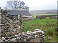
Broch in Sutherland
Ruins of a broch with walls preserved up to 1,5 m of height and 4,5 m thick. Entrance of the broch was located in it's NW sector.
You may be viewing yesterday's version of this page. To see the most up to date information please register for a free account.
Do not use the above information on other web sites or publications without permission of the contributor.
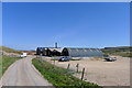
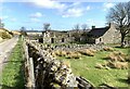
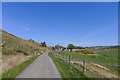
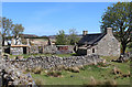
Nearby Images from Geograph Britain and Ireland:
©2019(licence)
©2024(licence)
©2019(licence)
©2019(licence)
©2009(licence)
The above images may not be of the site on this page, they are loaded from Geograph.
Please Submit an Image of this site or go out and take one for us!
Click here to see more info for this site
Nearby sites
Key: Red: member's photo, Blue: 3rd party photo, Yellow: other image, Green: no photo - please go there and take one, Grey: site destroyed
Download sites to:
KML (Google Earth)
GPX (GPS waypoints)
CSV (Garmin/Navman)
CSV (Excel)
To unlock full downloads you need to sign up as a Contributory Member. Otherwise downloads are limited to 50 sites.
Turn off the page maps and other distractions
Nearby sites listing. In the following links * = Image available
2.0km S 173° Leathad Carnaich (Dalhalvaig) Cairn (NC89135554)
4.1km S 175° Trantlemore* Broch or Nuraghe (NC89185338)
6.6km S 170° The Borg* Broch or Nuraghe (NC89935095)
7.9km N 353° Tobar Malaig* Holy Well or Sacred Spring (NC882654)
9.8km NE 37° Sandside House 2 Early Christian Sculptured Stone (NC95196517)
9.9km NE 38° Sandside House 1 Class I Pictish Symbol Stone (NC95226518)
10.4km WNW 298° Broch near Armadale* Broch or Nuraghe (NC799626)
10.5km NE 54° Borlum Stone Row / Alignment (NC97706340)
10.8km NE 46° Reay Cross Slab* Class III Pictish Cross Slab (NC96916483)
11.6km ENE 59° Achvarasdal Burn* Standing Stone (Menhir) (NC99156316)
11.8km NE 51° Achvarasdal Broch Broch or Nuraghe (NC98346469)
12.1km S 176° Dail Dhonuill Enclosures and hut circle Ancient Village or Settlement (NC895454)
12.4km S 172° Dail Dhonuill Hut Circles, Field Systems and Burnt Mounds Ancient Village or Settlement (NC903452)
12.6km NE 54° Achunabust* Broch or Nuraghe (NC99436463)
12.8km NE 45° Cnoc Urray Broch or Nuraghe (NC98386630)
12.9km NE 49° Achbuiligan Tulloch Broch or Nuraghe (NC98946570)
14.1km NE 51° Druim Na Ceud Stone Row / Alignment (ND00206610)
14.4km NE 52° Upper Dounreay* Standing Stone (Menhir) (ND00626607)
14.4km NE 52° Upper Dounreay II Multiple Stone Rows / Avenue (ND007660)
14.5km NE 56° Na Tri Sithean* Chambered Cairn (ND01246532)
14.5km NE 53° Upper Dounreay Cairn* Chambered Cairn (ND00796604)
14.6km NE 56° Cnoc Freiceadain* Chambered Cairn (ND0132065415)
14.7km W 269° Achamore Chambered Cairn (NC74175779)
14.8km NE 45° Cnoc Na H-uiseig Chambered Cairn (NC99696772)
14.8km NE 54° Upper Dounreay I* Multiple Stone Rows / Avenue (ND01176596)
View more nearby sites and additional images


 We would like to know more about this location. Please feel free to add a brief description and any relevant information in your own language.
 Wir möchten mehr über diese Stätte erfahren. Bitte zögern Sie nicht, eine kurze Beschreibung und relevante Informationen in Deutsch hinzuzufügen.
 Nous aimerions en savoir encore un peu sur les lieux. S'il vous plaît n'hesitez pas à ajouter une courte description et tous les renseignements pertinents dans votre propre langue.
 Quisieramos informarnos un poco más de las lugares. No dude en añadir una breve descripción y otros datos relevantes en su propio idioma.