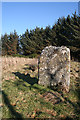
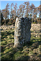
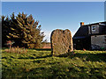
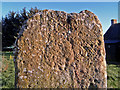
<< Our Photo Pages >> Kebbuck Stone - Class I / Class II Hybrid Pictish Symbol Stone in Scotland in Highlands
Submitted by Cosmic on Tuesday, 05 October 2004 Page Views: 10219
Early Medieval (Dark Age)Site Name: Kebbuck Stone Alternative Name: Kebach Stone, Kebbock Stone Cross-SlabCountry: Scotland
NOTE: This site is 1.6 km away from the location you searched for.
County: Highlands Type: Class I / Class II Hybrid Pictish Symbol Stone
Nearest Town: Nairn Nearest Village: Blackcastle
Map Ref: NH826555 Landranger Map Number: 27
Latitude: 57.574254N Longitude: 3.964674W
Condition:
| 5 | Perfect |
| 4 | Almost Perfect |
| 3 | Reasonable but with some damage |
| 2 | Ruined but still recognisable as an ancient site |
| 1 | Pretty much destroyed, possibly visible as crop marks |
| 0 | No data. |
| -1 | Completely destroyed |
| 5 | Superb |
| 4 | Good |
| 3 | Ordinary |
| 2 | Not Good |
| 1 | Awful |
| 0 | No data. |
| 5 | Can be driven to, probably with disabled access |
| 4 | Short walk on a footpath |
| 3 | Requiring a bit more of a walk |
| 2 | A long walk |
| 1 | In the middle of nowhere, a nightmare to find |
| 0 | No data. |
| 5 | co-ordinates taken by GPS or official recorded co-ordinates |
| 4 | co-ordinates scaled from a detailed map |
| 3 | co-ordinates scaled from a bad map |
| 2 | co-ordinates of the nearest village |
| 1 | co-ordinates of the nearest town |
| 0 | no data |
Internal Links:
External Links:
")
It is thought to be the burial ground of an ancient chief ,who died fighting over a cheese! Another use for the stone was to divide the bounderies of Ardersier and Nairn
You may be viewing yesterday's version of this page. To see the most up to date information please register for a free account.
")
Do not use the above information on other web sites or publications without permission of the contributor.
Nearby Images from Geograph Britain and Ireland:
©2013(licence)
©2013(licence)
©2006(licence)

©2006(licence)
©2006(licence)
The above images may not be of the site on this page, they are loaded from Geograph.
Please Submit an Image of this site or go out and take one for us!
Click here to see more info for this site
Nearby sites
Key: Red: member's photo, Blue: 3rd party photo, Yellow: other image, Green: no photo - please go there and take one, Grey: site destroyed
Download sites to:
KML (Google Earth)
GPX (GPS waypoints)
CSV (Garmin/Navman)
CSV (Excel)
To unlock full downloads you need to sign up as a Contributory Member. Otherwise downloads are limited to 50 sites.
Turn off the page maps and other distractions
Nearby sites listing. In the following links * = Image available
2.5km S 179° Loch of the Clans Crannog* Crannog (NH82575297)
5.6km SE 145° Cawdor* Standing Stone (Menhir) (NH857508)
8.0km SSE 148° Little Urchany* Clava Cairn (NH8665648566)
8.5km SSW 212° Dalcross Mains* Stone Circle (NH779484)
9.0km SSW 201° Dalgrambich Farm* Standing Stones (NH79104715)
9.1km WNW 282° Groam House Museum* Museum (NH737577)
9.8km E 89° Auldearn Stone Circle* Stone Circle (NH9246755309)
10.4km W 274° St Boniface's Well (Fortrose)* Holy Well or Sacred Spring (NH722565)
10.5km E 92° Auldearn Stone Row* Stone Row / Alignment (NH93125486)
11.4km SW 231° Newton Of Petty Ring Cairn (NH73484858)
11.5km NW 305° Glenurquhart Grey Cairn* Cairn (NH73386247)
11.9km NNW 348° St Mary's Well (Cromarty)* Holy Well or Sacred Spring (NH805672)
11.9km N 349° Fiddler's Well Holy Well or Sacred Spring (NH807673)
12.0km ESE 117° Achnatone* Stone Circle (NH932498)
12.7km SSW 209° Mains of Clava SE* Cairn (NH76054457)
12.7km SW 231° Cullearnie* Stone Circle (NH72504768)
12.7km SW 215° Cumberland's Stone* Natural Stone / Erratic / Other Natural Feature (NH74974526)
12.8km E 97° Moyness* Stone Circle (NH95275364)
12.8km SSW 210° Balnuaran of Clava (Stone)* Standing Stone (Menhir) (NH758446)
12.9km SSW 210° Balnuaran Of Clava NE* Clava Cairn (NH7576744478)
13.0km SSW 210° Balnuaran of Clava Centre* Ring Cairn (NH7572044438)
13.0km SSW 210° Balnuaran of Clava E* Clava Cairn (NH75804435)
13.0km SSW 210° Balnuaran of Clava Kerb Cairn* Cairn (NH7567444422)
13.1km SSW 210° Balnuaran of Clava SW* Clava Cairn (NH7568944380)
13.3km E 83° Macbeth's Hillock Natural Stone / Erratic / Other Natural Feature (NH95905675)
View more nearby sites and additional images


 We would like to know more about this location. Please feel free to add a brief description and any relevant information in your own language.
 Wir möchten mehr über diese Stätte erfahren. Bitte zögern Sie nicht, eine kurze Beschreibung und relevante Informationen in Deutsch hinzuzufügen.
 Nous aimerions en savoir encore un peu sur les lieux. S'il vous plaît n'hesitez pas à ajouter une courte description et tous les renseignements pertinents dans votre propre langue.
 Quisieramos informarnos un poco más de las lugares. No dude en añadir una breve descripción y otros datos relevantes en su propio idioma.