<< Our Photo Pages >> Milton Loch Central - Crannog in Scotland in Dumfries and Galloway
Submitted by markj99 on Tuesday, 27 June 2023 Page Views: 574
Iron Age and Later PrehistorySite Name: Milton Loch Central Alternative Name: Milton Loch 3Country: Scotland County: Dumfries and Galloway Type: Crannog
Nearest Town: Dumfries Nearest Village: Crocketford
Map Ref: NX83947149
Latitude: 55.024358N Longitude: 3.817014W
Condition:
| 5 | Perfect |
| 4 | Almost Perfect |
| 3 | Reasonable but with some damage |
| 2 | Ruined but still recognisable as an ancient site |
| 1 | Pretty much destroyed, possibly visible as crop marks |
| 0 | No data. |
| -1 | Completely destroyed |
| 5 | Superb |
| 4 | Good |
| 3 | Ordinary |
| 2 | Not Good |
| 1 | Awful |
| 0 | No data. |
| 5 | Can be driven to, probably with disabled access |
| 4 | Short walk on a footpath |
| 3 | Requiring a bit more of a walk |
| 2 | A long walk |
| 1 | In the middle of nowhere, a nightmare to find |
| 0 | No data. |
| 5 | co-ordinates taken by GPS or official recorded co-ordinates |
| 4 | co-ordinates scaled from a detailed map |
| 3 | co-ordinates scaled from a bad map |
| 2 | co-ordinates of the nearest village |
| 1 | co-ordinates of the nearest town |
| 0 | no data |
Internal Links:
External Links:
I have visited· I would like to visit
markj99 visited on 22nd Jun 2023 - their rating: Cond: 2 Amb: 3 Access: 3 Directions to Green Island, Milton Loch: Take the Park of Brandedleys turn off the A75 on the SW edge of Crocketford. Follow the road for c. 0.8 mile to Auchengibbert Farm. Bear left to Kirkgunzeon for c. 0.2 mile to a passing place on the left. Park up and follow a vague path along the margin of the field to the W bank of Milton Loch. My route is viewable on Milton Loch Crannogs.
")
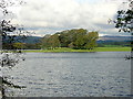
Milton Loch Central Crannog is located centrally in Milton Loch c. 1 mile SE of Crocketford in Dumfries and Galloway. According to Canmore ID 72519 the island was identified as a crannog by an underwater examination in 1989. It was constructed using wooden piles and transverse timbers laid on a bed of boulders set on a natural outcrop. The crannog measures c. 20 metres across above the water level, sloping away to c. 30 metres in diameter at a depth of c. 3 metres. Wooden samples taken from the crannog have been dated to c. 480 AD.
The crannog is prominent in the middle of Milton Loch, a low circular island covered by mature trees. According to Canmore ID 72521 an island lying c. 110 metres W of the crannog was examined in 2002. The island was found to be a natural outcrop.
You may be viewing yesterday's version of this page. To see the most up to date information please register for a free account.
")
")
")
Do not use the above information on other web sites or publications without permission of the contributor.
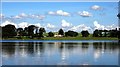
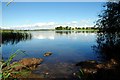
Nearby Images from Geograph Britain and Ireland:

©2024(licence)
©2006(licence)
©2007(licence)
©2007(licence)

©2024(licence)
The above images may not be of the site on this page, they are loaded from Geograph.
Please Submit an Image of this site or go out and take one for us!
Click here to see more info for this site
Nearby sites
Key: Red: member's photo, Blue: 3rd party photo, Yellow: other image, Green: no photo - please go there and take one, Grey: site destroyed
Download sites to:
KML (Google Earth)
GPX (GPS waypoints)
CSV (Garmin/Navman)
CSV (Excel)
To unlock full downloads you need to sign up as a Contributory Member. Otherwise downloads are limited to 50 sites.
Turn off the page maps and other distractions
Nearby sites listing. In the following links * = Image available
175m NNW 328° Green Island (Milton Loch)* Misc. Earthwork (NX83857164)
394m N 350° Milton Loch NW* Crannog (NX83887188)
446m SE 129° Milton Loch SE* Crannog (NX84287120)
5.2km SSE 149° St Winning's Well (Kirkgunzeon)* Holy Well or Sacred Spring (NX86526699)
5.5km SSE 150° Kirkgunzeon Stone Circle (NX86576668)
6.1km ENE 74° Lochrutton Loch* Crannog (NX89837299)
6.3km NNE 27° The Doons* Hillfort (NX86987699)
7.1km NNE 27° Angel Well (Barnsoul) Holy Well or Sacred Spring (NX87337770)
8.3km ENE 72° Easthill* Stone Circle (NX91937388)
8.5km SW 224° St Michael's Well (Crossmichael) Holy Well or Sacred Spring (NX7783865566)
8.9km NE 55° Beacon Hill (Dumfries and Galloway)* Hillfort (NX91397643)
10.2km SSW 193° Slot Well (Buittle) Holy Well or Sacred Spring (NX8134861618)
10.4km NE 38° Hall Hill* Hillfort (NX90597949)
10.5km SW 216° Ernespie* Stone Circle (NX77476321)
10.5km SSW 198° Rumbling Well (Buittle) Holy Well or Sacred Spring (NX8050061547)
10.6km NE 54° Ladye Well (Terregles) Holy Well or Sacred Spring (NX92767744)
11.4km E 85° Picts Knowe* Henge (NX95387213)
11.4km NE 40° Holywood Cursus Cursus (NX91558004)
11.5km SW 228° Greenlaw Cairn (NX75186404)
11.6km E 85° St Queran's Well* Holy Well or Sacred Spring (NX95597222)
12.4km ENE 71° Troqueer Cursus Cursus (NX95837512)
12.7km ENE 72° Troqueer Cursus Cursus (NX96137517)
12.8km N 356° Glenesslin Schoolhouse* Cairn (NX83488433)
12.9km SW 215° Carlingwark Loch* Crannog (NX76296107)
13.1km SE 138° Slewcairn* Cairn (NX924615)
View more nearby sites and additional images


 We would like to know more about this location. Please feel free to add a brief description and any relevant information in your own language.
 Wir möchten mehr über diese Stätte erfahren. Bitte zögern Sie nicht, eine kurze Beschreibung und relevante Informationen in Deutsch hinzuzufügen.
 Nous aimerions en savoir encore un peu sur les lieux. S'il vous plaît n'hesitez pas à ajouter une courte description et tous les renseignements pertinents dans votre propre langue.
 Quisieramos informarnos un poco más de las lugares. No dude en añadir una breve descripción y otros datos relevantes en su propio idioma.