<< Text Pages >> Saith Maen Cairn - Ring Cairn in Wales in Powys
Submitted by vicky on Wednesday, 03 March 2004 Page Views: 6500
Neolithic and Bronze AgeSite Name: Saith Maen CairnCountry: Wales County: Powys Type: Ring Cairn
Nearest Town: Brecon Nearest Village: Craig-y-nos
Map Ref: SN833154 Landranger Map Number: 160
Latitude: 51.824994N Longitude: 3.694731W
Condition:
| 5 | Perfect |
| 4 | Almost Perfect |
| 3 | Reasonable but with some damage |
| 2 | Ruined but still recognisable as an ancient site |
| 1 | Pretty much destroyed, possibly visible as crop marks |
| 0 | No data. |
| -1 | Completely destroyed |
| 5 | Superb |
| 4 | Good |
| 3 | Ordinary |
| 2 | Not Good |
| 1 | Awful |
| 0 | No data. |
| 5 | Can be driven to, probably with disabled access |
| 4 | Short walk on a footpath |
| 3 | Requiring a bit more of a walk |
| 2 | A long walk |
| 1 | In the middle of nowhere, a nightmare to find |
| 0 | No data. |
| 5 | co-ordinates taken by GPS or official recorded co-ordinates |
| 4 | co-ordinates scaled from a detailed map |
| 3 | co-ordinates scaled from a bad map |
| 2 | co-ordinates of the nearest village |
| 1 | co-ordinates of the nearest town |
| 0 | no data |
Internal Links:
External Links:
Ring Cairn in Powys
Have you visited this site? Please add a comment below.
Note: This site is located on private land - permission should be sought before visiting.
You may be viewing yesterday's version of this page. To see the most up to date information please register for a free account.
Do not use the above information on other web sites or publications without permission of the contributor.
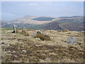
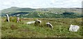
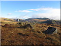
Nearby Images from Geograph Britain and Ireland:
©2005(licence)
©2018(licence)

©2024(licence)

©2024(licence)
©2012(licence)
The above images may not be of the site on this page, they are loaded from Geograph.
Please Submit an Image of this site or go out and take one for us!
Click here to see more info for this site
Nearby sites
Key: Red: member's photo, Blue: 3rd party photo, Yellow: other image, Green: no photo - please go there and take one, Grey: site destroyed
Download sites to:
KML (Google Earth)
GPX (GPS waypoints)
CSV (Garmin/Navman)
CSV (Excel)
To unlock full downloads you need to sign up as a Contributory Member. Otherwise downloads are limited to 50 sites.
Turn off the page maps and other distractions
Nearby sites listing. In the following links * = Image available
6m E 98° Saith Maen NW* Stone Row / Alignment (SN8330615399)
510m SW 234° Pwll-y-Wythen Fach* Ancient Village or Settlement (SN8288115107)
859m NE 34° Dan-yr-Ogof* Cave or Rock Shelter (SN838161)
948m SSW 197° The Sleeping Giant* Natural Stone / Erratic / Other Natural Feature (SN830145)
1.3km SSW 200° Cribarth Cairns* Cairn (SN8283514203)
1.5km N 359° Twyn Ddu* Cairn (SN833169)
1.7km E 90° Powell's Cave Cave or Rock Shelter (SN84991535)
2.8km E 89° Penwyllt Cairn* Cairn (SN8606715391)
2.9km NNW 337° Waun Fignen Felen Ancient Village or Settlement (SN82201810)
3.0km E 93° Careg Lywd 2* Stone Row / Alignment (SN8629315186)
3.0km ESE 104° Saith Maen SE* Stone Row / Alignment (SN862146)
3.1km ESE 101° The Gnomen Standing Stone (Menhir) (SN8635214716)
3.2km E 99° Saith Maen East Cairn* Cairn (SN8642414831)
3.4km ESE 113° Pump Maen (Five Stones)* Stone Row / Alignment (SN86361400)
3.8km NW 322° Pwll-y-Cig Cairn* Cairn (SN8105818446)
4.2km ENE 76° The Nipple* Cairn (SN87441635)
4.4km E 85° Carreg Cadno* Stone Row / Alignment (SN87671569)
4.5km ENE 66° Pwll Byfre Hut Circle 2 Ancient Village or Settlement (SN87471711)
4.5km ENE 66° Pwll Byfre Hut Circle 1 Ancient Village or Settlement (SN87501711)
4.5km NW 308° Banwen Gwys 2* Cairn (SN7977318259)
4.6km NW 310° Banwen Gwys 1* Cairn (SN7984818471)
4.7km W 264° Llorfa* Stone Circle (SN7861915010)
5.4km NNE 19° Nant-y-Llyn (Powys)* Cairn (SN85142043)
5.4km W 265° Llwyncwmstabl* Cairn (SN77851509)
5.5km NNE 18° Cerrig Duon stone circle* Stone Circle (SN85122061)
View more nearby sites and additional images


 We would like to know more about this location. Please feel free to add a brief description and any relevant information in your own language.
 Wir möchten mehr über diese Stätte erfahren. Bitte zögern Sie nicht, eine kurze Beschreibung und relevante Informationen in Deutsch hinzuzufügen.
 Nous aimerions en savoir encore un peu sur les lieux. S'il vous plaît n'hesitez pas à ajouter une courte description et tous les renseignements pertinents dans votre propre langue.
 Quisieramos informarnos un poco más de las lugares. No dude en añadir una breve descripción y otros datos relevantes en su propio idioma.