 with our Megalithic Portal iPhone app")

<< Text Pages >> Dalchirla East (Muthill) - Standing Stones in Scotland in Perth and Kinross
Submitted by Anne T on Wednesday, 02 August 2017 Page Views: 1618
Neolithic and Bronze AgeSite Name: Dalchirla East (Muthill) Alternative Name: Muthill; Dalchirla FarmCountry: Scotland County: Perth and Kinross Type: Standing Stones
Nearest Town: Crieff Nearest Village: Ochtermuthill
Map Ref: NN8244615893
Latitude: 56.320798N Longitude: 3.902296W
Condition:
| 5 | Perfect |
| 4 | Almost Perfect |
| 3 | Reasonable but with some damage |
| 2 | Ruined but still recognisable as an ancient site |
| 1 | Pretty much destroyed, possibly visible as crop marks |
| 0 | No data. |
| -1 | Completely destroyed |
| 5 | Superb |
| 4 | Good |
| 3 | Ordinary |
| 2 | Not Good |
| 1 | Awful |
| 0 | No data. |
| 5 | Can be driven to, probably with disabled access |
| 4 | Short walk on a footpath |
| 3 | Requiring a bit more of a walk |
| 2 | A long walk |
| 1 | In the middle of nowhere, a nightmare to find |
| 0 | No data. |
| 5 | co-ordinates taken by GPS or official recorded co-ordinates |
| 4 | co-ordinates scaled from a detailed map |
| 3 | co-ordinates scaled from a bad map |
| 2 | co-ordinates of the nearest village |
| 1 | co-ordinates of the nearest town |
| 0 | no data |
Be the first person to rate this site - see the 'Contribute!' box in the right hand menu.
Internal Links:
External Links:
Standing Stones in Perth and Kinross
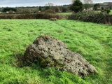
These two prehistoric standing stones are recorded as Canmore ID 25355. Their entry from a 1911 report says: "Two upright stones which are traditionally said to be the remains of a Druidicidal Temple (Name Book 1860). They are 7' 8" and 4' 4" high and 8' apart. There is no indication of the former position of other stones." An entry from 1967 adds: "Between them, and in line, is an earthfast stone, 1.0m long by 0.5m wide by 0.3m high, the significance of which could not be ascertained. There is no indication of these stones having formed part of a stone circle."
The Northern Antiquarian (TNA) also has a page for this site - see their entry for Dalchirla (east), Muthill, Perthshire which contains photographs, directions for finding these stones and a brief archaeology and history. They also show a diagram of "Thom's geometry of Dlachirla' and add that the stone laid between the two standing stones has cup marks. They add: "the measurements and angles of Dalchira East were examined by the late great Alexander Thom (1967; 1990) who thought they had been positioned specifically to observe and predict lunar movements across the sky, saying that the alignment of these stones “shows the declination of the Moon rising at the minor standstill.” He may have been right."
Note: Have you visited this site? Do you have any comments or photographs to add?
You may be viewing yesterday's version of this page. To see the most up to date information please register for a free account.
Do not use the above information on other web sites or publications without permission of the contributor.
Nearby Images from Geograph Britain and Ireland:

©2008(licence)

©2008(licence)
©2006(licence)
©2019(licence)
©2013(licence)
The above images may not be of the site on this page, they are loaded from Geograph.
Please Submit an Image of this site or go out and take one for us!
Click here to see more info for this site
Nearby sites
Key: Red: member's photo, Blue: 3rd party photo, Yellow: other image, Green: no photo - please go there and take one, Grey: site destroyed
Download sites to:
KML (Google Earth)
GPX (GPS waypoints)
CSV (Garmin/Navman)
CSV (Excel)
To unlock full downloads you need to sign up as a Contributory Member. Otherwise downloads are limited to 50 sites.
Turn off the page maps and other distractions
Nearby sites listing. In the following links * = Image available
288m NW 322° Dalchirla North (Muthill) Standing Stone (Menhir) (NN8227416125)
3.2km SSE 168° Cairn Wochel Long Barrow (NN83011276)
3.5km WNW 285° Dunruchan D (Muthill)* Standing Stone (Menhir) (NN7904416881)
3.6km WNW 289° Dunruchan C (Muthill)* Standing Stone (Menhir) (NN7910817137)
3.6km WNW 283° Dunruchan E (Muthill)* Standing Stone (Menhir) (NN7899716819)
3.6km WNW 282° Craigneich Stones* Standing Stones (NN7894816756)
3.8km WNW 300° Craigneich Farm* Standing Stone (Menhir) (NN7922617871)
4.3km WNW 292° Giant's Knowe (Culloch) Cairn (NN78481762)
4.7km NE 38° Concraig* Standing Stone (Menhir) (NN8548419503)
4.9km N 352° Strowan (Crieff)* Cairn (NN819208)
5.0km NNE 19° Rottenreoch Chambered Cairn (NN842206)
5.1km NE 51° Crieff Cursus Cursus (NN86531897)
5.2km NE 50° Crieff Cursus Cursus (NN86561910)
5.2km NW 313° Auchingarrich Farm Standing Stone (Menhir) (NN78731958)
5.4km NE 38° Dargill* Standing Stone (Menhir) (NN85922004)
6.1km N 359° Samson's Stone Standing Stone (Menhir) (NN82512202)
6.2km NE 42° Crieff Cursus Cursus (NN86702040)
6.4km NE 38° Duchlage, Crieff Standing Stone (Menhir) (NN86552079)
6.8km NW 311° Comrie Cursus Cursus (NN77422047)
6.9km NW 312° West Cowden* Stone Row / Alignment (NN7744520645)
6.9km NE 34° Crieff Cross Slab* Class III Pictish Cross Slab (NN865215)
6.9km NW 310° Comrie Cursus Cursus (NN77252048)
6.9km NW 319° Dalginross* Stone Circle (NN7802521264)
7.2km NNW 339° Lawers* Standing Stone (Menhir) (NN80102267)
7.4km N 349° Clathick House Standing Stone (Menhir) (NN81212315)
View more nearby sites and additional images


 We would like to know more about this location. Please feel free to add a brief description and any relevant information in your own language.
 Wir möchten mehr über diese Stätte erfahren. Bitte zögern Sie nicht, eine kurze Beschreibung und relevante Informationen in Deutsch hinzuzufügen.
 Nous aimerions en savoir encore un peu sur les lieux. S'il vous plaît n'hesitez pas à ajouter une courte description et tous les renseignements pertinents dans votre propre langue.
 Quisieramos informarnos un poco más de las lugares. No dude en añadir una breve descripción y otros datos relevantes en su propio idioma.