<< Text Pages >> Auchingarrich Farm - Standing Stone (Menhir) in Scotland in Perth and Kinross
Submitted by BigSweetie on Friday, 26 March 2004 Page Views: 9491
Neolithic and Bronze AgeSite Name: Auchingarrich Farm Alternative Name: Roman StoneCountry: Scotland County: Perth and Kinross Type: Standing Stone (Menhir)
Nearest Town: Comrie
Map Ref: NN78731958 Landranger Map Number: 57
Latitude: 56.352966N Longitude: 3.964041W
Condition:
| 5 | Perfect |
| 4 | Almost Perfect |
| 3 | Reasonable but with some damage |
| 2 | Ruined but still recognisable as an ancient site |
| 1 | Pretty much destroyed, possibly visible as crop marks |
| 0 | No data. |
| -1 | Completely destroyed |
| 5 | Superb |
| 4 | Good |
| 3 | Ordinary |
| 2 | Not Good |
| 1 | Awful |
| 0 | No data. |
| 5 | Can be driven to, probably with disabled access |
| 4 | Short walk on a footpath |
| 3 | Requiring a bit more of a walk |
| 2 | A long walk |
| 1 | In the middle of nowhere, a nightmare to find |
| 0 | No data. |
| 5 | co-ordinates taken by GPS or official recorded co-ordinates |
| 4 | co-ordinates scaled from a detailed map |
| 3 | co-ordinates scaled from a bad map |
| 2 | co-ordinates of the nearest village |
| 1 | co-ordinates of the nearest town |
| 0 | no data |
Internal Links:
External Links:
I have visited· I would like to visit
Uralsdaughter visited on 22nd Aug 2018 - their rating: Cond: 5 Amb: 3 Access: 5
For more information see Canmore site no. 24795 and The Northern Antiquarian's page for Auchingarroch, Muthill, Perthshire.
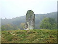
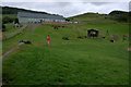
Canmore tell us that this stone is supposed to mark the grave on one of the heroes who fell at the battle of Mons Grampus and the stone: "stands on a small grassy knoll which shows no signs of any other stones. A square-edged, massive block of conglomerate schist with a basal girth of 12ft 8ins and a height of 8ft 7ins. Locally known as "the Roman Stone" but no different from the majority of standing stones .... has three small cup marks on its eastern side and one large cup mark on its western side."
The Northern Antiquarian record contains directions for finding the stone, a brief archaeology & history, local folklore, photographs and a 1911 sketch.
Note: Have you visited this site? Do you have any photographs or comments to add?
You may be viewing yesterday's version of this page. To see the most up to date information please register for a free account.
Do not use the above information on other web sites or publications without permission of the contributor.
Nearby Images from Geograph Britain and Ireland:
©2008(licence)
©2009(licence)
©2011(licence)
©2009(licence)
©2011(licence)
The above images may not be of the site on this page, they are loaded from Geograph.
Please Submit an Image of this site or go out and take one for us!
Click here to see more info for this site
Nearby sites
Key: Red: member's photo, Blue: 3rd party photo, Yellow: other image, Green: no photo - please go there and take one, Grey: site destroyed
Download sites to:
KML (Google Earth)
GPX (GPS waypoints)
CSV (Garmin/Navman)
CSV (Excel)
To unlock full downloads you need to sign up as a Contributory Member. Otherwise downloads are limited to 50 sites.
Turn off the page maps and other distractions
Nearby sites listing. In the following links * = Image available
1.6km WNW 303° Comrie Cursus Cursus (NN77422047)
1.7km NW 308° West Cowden* Stone Row / Alignment (NN7744520645)
1.7km WNW 300° Comrie Cursus Cursus (NN77252048)
1.8km SSE 162° Craigneich Farm* Standing Stone (Menhir) (NN7922617871)
1.8km NNW 336° Dalginross* Stone Circle (NN7802521264)
2.0km S 186° Giant's Knowe (Culloch) Cairn (NN78481762)
2.5km S 170° Dunruchan C (Muthill)* Standing Stone (Menhir) (NN7910817137)
2.7km WNW 293° Craggish Stone Row / Alignment (NN763207)
2.7km S 172° Dunruchan D (Muthill)* Standing Stone (Menhir) (NN7904416881)
2.8km WNW 302° Comrie Cursus Cursus (NN76422112)
2.8km S 173° Dunruchan E (Muthill)* Standing Stone (Menhir) (NN7899716819)
2.8km S 174° Craigneich Stones* Standing Stones (NN7894816756)
3.0km NW 323° Tom na Chessaig Stone Circle (NN770220)
3.0km NW 305° Craggish (Comrie) Standing Stones (NN763214)
3.0km NNW 336° Coney Hill (Comrie)* Misc. Earthwork (NN77552238)
3.4km NNE 22° Lawers* Standing Stone (Menhir) (NN80102267)
3.4km ENE 67° Strowan (Crieff)* Cairn (NN819208)
4.3km NW 310° Tullybannocher* Stone Circle (NN75482247)
4.3km NNE 33° Clathick House Standing Stone (Menhir) (NN81212315)
4.5km NE 55° Samson's Stone Standing Stone (Menhir) (NN82512202)
4.9km SE 133° Dalchirla North (Muthill) Standing Stone (Menhir) (NN8227416125)
5.2km SE 133° Dalchirla East (Muthill) Standing Stones (NN8244615893)
5.5km ENE 78° Rottenreoch Chambered Cairn (NN842206)
5.6km N 355° Balmuick* Stone Circle (NN78362513)
5.8km NW 304° Cluan-Glasdale Stone Circle (NN7423)
View more nearby sites and additional images


 We would like to know more about this location. Please feel free to add a brief description and any relevant information in your own language.
 Wir möchten mehr über diese Stätte erfahren. Bitte zögern Sie nicht, eine kurze Beschreibung und relevante Informationen in Deutsch hinzuzufügen.
 Nous aimerions en savoir encore un peu sur les lieux. S'il vous plaît n'hesitez pas à ajouter une courte description et tous les renseignements pertinents dans votre propre langue.
 Quisieramos informarnos un poco más de las lugares. No dude en añadir una breve descripción y otros datos relevantes en su propio idioma.