


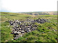
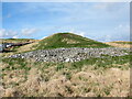
<< Our Photo Pages >> Carn Saith-Wraig, Round Cairn - Round Cairn in Wales in Ceredigion
Submitted by geoffstickland on Thursday, 13 August 2020 Page Views: 1121
Neolithic and Bronze AgeSite Name: Carn Saith-Wraig, Round Cairn Alternative Name: English Translation Cairn of the Seven BridesCountry: Wales
NOTE: This site is 1.6 km away from the location you searched for.
County: Ceredigion Type: Round Cairn
Nearest Town: Tregaron Nearest Village: Llanddewi Brefi
Map Ref: SN77185288
Latitude: 52.160488N Longitude: 3.796925W
Condition:
| 5 | Perfect |
| 4 | Almost Perfect |
| 3 | Reasonable but with some damage |
| 2 | Ruined but still recognisable as an ancient site |
| 1 | Pretty much destroyed, possibly visible as crop marks |
| 0 | No data. |
| -1 | Completely destroyed |
| 5 | Superb |
| 4 | Good |
| 3 | Ordinary |
| 2 | Not Good |
| 1 | Awful |
| 0 | No data. |
| 5 | Can be driven to, probably with disabled access |
| 4 | Short walk on a footpath |
| 3 | Requiring a bit more of a walk |
| 2 | A long walk |
| 1 | In the middle of nowhere, a nightmare to find |
| 0 | No data. |
| 5 | co-ordinates taken by GPS or official recorded co-ordinates |
| 4 | co-ordinates scaled from a detailed map |
| 3 | co-ordinates scaled from a bad map |
| 2 | co-ordinates of the nearest village |
| 1 | co-ordinates of the nearest town |
| 0 | no data |
Internal Links:
External Links:
I have visited· I would like to visit
Penbron geoffstickland have visited here
")
You may be viewing yesterday's version of this page. To see the most up to date information please register for a free account.
")
")
Do not use the above information on other web sites or publications without permission of the contributor.
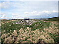
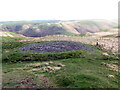
Nearby Images from Geograph Britain and Ireland:
©2023(licence)
©2023(licence)
©2023(licence)
©2023(licence)

©2007(licence)
The above images may not be of the site on this page, they are loaded from Geograph.
Please Submit an Image of this site or go out and take one for us!
Click here to see more info for this site
Nearby sites
Key: Red: member's photo, Blue: 3rd party photo, Yellow: other image, Green: no photo - please go there and take one, Grey: site destroyed
Download sites to:
KML (Google Earth)
GPX (GPS waypoints)
CSV (Garmin/Navman)
CSV (Excel)
To unlock full downloads you need to sign up as a Contributory Member. Otherwise downloads are limited to 50 sites.
Turn off the page maps and other distractions
Nearby sites listing. In the following links * = Image available
120m NW 317° Carn Saith-Wraig, Ring Cairn* Ring Cairn (SN77105297)
723m NW 323° Blaen nant y Rhiw Round Cairn* Cairn (SN76765347)
1.1km ENE 71° Nant Llwyd Standing Stones* Standing Stones (SN782532)
2.9km NW 308° Bryn y Gorlan* Stone Circle (SN74945473)
3.6km SSW 203° Cefn Cnwcheithinog* Standing Stone (Menhir) (SN757496)
5.0km SW 223° Cefn Gwernffrwd Row* Stone Row / Alignment (SN7370049328)
5.0km SW 223° Cefn Gwernffrwd stone circle* Stone Circle (SN7370049328)
5.2km N 351° Cefn Cerrig* Cairn (SN76465801)
5.4km NNE 33° Eagair Gerwyn Cairn Cemetary* Cairn (SN80265736)
5.5km N 354° Cefn Cerrig Cairn/Round Barrow* Round Barrow(s) (SN7673258333)
5.5km NNW 348° Nant-Y-Maen Stone* Standing Stone (Menhir) (SN76175830)
5.7km NE 44° Castell Llygoden Platform Cairn* Cairn (SN81205689)
5.9km SSW 195° Cefn Gwenffrwd Maenhir* Standing Stone (Menhir) (SN75514725)
6.0km N 360° Cefn y Cnuc Cairn* Cairn (SN7731658859)
6.0km SSW 192° Randirmwyn Standing Stone* Standing Stone (Menhir) (SN758470)
6.3km SE 131° Mynydd Trawsnant Cairn* Cairn (SN81834863)
6.3km NNW 340° Blaen Camddwr Cairn* Cairn (SN7516558906)
6.5km SE 140° Cefn Ystrad Ffin Cairn* Cairn (SN81234776)
6.6km ESE 116° Esgair Garn* Cairn (SN83084983)
6.7km SW 222° Esgair Nant-y-Maen cairn* Ring Cairn (SN72544798)
6.9km S 175° Ty Newydd Standing Stone* Standing Stone (Menhir) (SN776460)
7.0km SSE 154° Cerrig Cedny* Cairn (SN80144651)
7.0km S 180° Gelli Burial Chamber* Chambered Cairn (SN7703845843)
7.1km SE 131° Croes Llywd Fach Cairn* Cairn (SN82374808)
7.1km ESE 117° Cefn Blaencwmhenog Cairn* Cairn (SN8349449500)
View more nearby sites and additional images


 We would like to know more about this location. Please feel free to add a brief description and any relevant information in your own language.
 Wir möchten mehr über diese Stätte erfahren. Bitte zögern Sie nicht, eine kurze Beschreibung und relevante Informationen in Deutsch hinzuzufügen.
 Nous aimerions en savoir encore un peu sur les lieux. S'il vous plaît n'hesitez pas à ajouter une courte description et tous les renseignements pertinents dans votre propre langue.
 Quisieramos informarnos un poco más de las lugares. No dude en añadir una breve descripción y otros datos relevantes en su propio idioma.